Noble Township, Wabash County, Indiana
| Noble Township | |
|---|---|
| Township | |
|
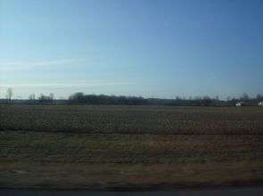
Countryside in Noble Township, northeast of Wabash | |
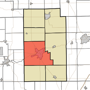 Location in Wabash County | |
| Coordinates: 40°47′54″N 85°51′08″W / 40.79833°N 85.85222°WCoordinates: 40°47′54″N 85°51′08″W / 40.79833°N 85.85222°W | |
| Country | United States |
| State | Indiana |
| County | Wabash |
| Government | |
| • Type | Indiana township |
| Area | |
| • Total | 82.39 sq mi (213.4 km2) |
| • Land | 81.9 sq mi (212 km2) |
| • Water | 0.49 sq mi (1.3 km2) 0.59% |
| Elevation | 705 ft (215 m) |
| Population (2010) | |
| • Total | 14,230 |
| • Density | 173.8/sq mi (67.1/km2) |
| ZIP codes | 46970, 46992 |
| GNIS feature ID | 453675 |
Noble Township is one of seven townships in Wabash County, Indiana, United States. As of the 2010 census, its population was 14,230 and it contained 6,476 housing units.[1]
History
The Teague Barn Wabash Importing Company Farm Stable was listed on the National Register of Historic Places in 2002.[2]
Geography
According to the 2010 census, the township has a total area of 82.39 square miles (213.4 km2), of which 81.9 square miles (212 km2) (or 99.41%) is land and 0.49 square miles (1.3 km2) (or 0.59%) is water.[1]
Cities, towns, villages
Unincorporated towns
- Pioneer at 40°44′16″N 85°53′44″W / 40.737820°N 85.895543°W
- Richvalley at 40°47′06″N 85°55′13″W / 40.785043°N 85.920266°W
- South Haven at 40°47′01″N 85°49′45″W / 40.783654°N 85.829152°W
- Sunnymede at 40°48′29″N 85°50′30″W / 40.808099°N 85.841653°W
- Valley Brook at 40°48′20″N 85°50′40″W / 40.805599°N 85.844431°W
(This list is based on USGS data and may include former settlements.)
Adjacent townships
- Paw Paw Township (north)
- Lagro Township (east)
- Liberty Township (southeast)
- Waltz Township (south)
- Butler Township, Miami County (southwest)
- Erie Township, Miami County (west)
- Richland Township, Miami County (northwest)
Cemeteries
The township contains these eight cemeteries: Friends, Hebrew, Huff, Martin Luther, Matlock, Memorial Lawns, Richvalley and Wallace.
Airports and landing strips
- Wabash Municipal Airport
Landmarks
- Field Of Dreams
School districts
- Metropolitan School District of Wabash County Schools
- Wabash City Schools
Political districts
- Indiana's 5th congressional district
- State House District 22
- State Senate District 17
References
- United States Census Bureau 2007 TIGER/Line Shapefiles
- United States Board on Geographic Names (GNIS)
- IndianaMap
- 1 2 "Population, Housing Units, Area, and Density: 2010 - County -- County Subdivision and Place -- 2010 Census Summary File 1". United States Census. Retrieved 2013-05-10.
- ↑ National Park Service (2010-07-09). "National Register Information System". National Register of Historic Places. National Park Service.
External links
Municipalities and communities of Wabash County, Indiana, United States | ||
|---|---|---|
| City | ||
| Towns | ||
| Townships | ||
| CDPs | ||
| Other unincorporated communities | ||
| Footnotes | ‡This populated place also has portions in an adjacent county or counties | |
This article is issued from Wikipedia - version of the 9/10/2016. The text is available under the Creative Commons Attribution/Share Alike but additional terms may apply for the media files.