Niagara River
| Niagara River | |
|---|---|
 Satellite image of the Niagara River. Flowing from Lake Erie in the south (bottom of image) to Lake Ontario in the north, the river passes around Grand Island before going over Niagara Falls, after which it narrows in the Niagara Gorge. Two hydropower reservoirs are visible just before the river widens after exiting the gorge. The Welland Canal is visible on the far left side of this image. (Source: NASA Visible Earth) | |
| Country | United States & Canada |
| Basin | |
| Main source | Lake Erie |
| River mouth | Lake Ontario |
| Basin size | 684,000 km2 (264,000 sq mi)[1] |
| Physical characteristics | |
| Length | 58 km (36 mi)[1] |
| Discharge |
|
The Niagara River (/naɪˈæɡrə/ ny-AG-ra) is a river that flows north from Lake Erie to Lake Ontario. It forms part of the border between the province of Ontario in Canada (on the west) and the state of New York in the United States (on the east). There are differing theories as to the origin of the river's name. According to Iroquoian scholar Bruce Trigger, "Niagara" is derived from the name given to a branch of the locally residing native Neutral Confederacy, who are described as being called the "Niagagarega" people on several late-17th-century French maps of the area.[3] According to George R. Stewart, it comes from the name of an Iroquois town called "Ongniaahra", meaning "point of land cut in two".[4]
The river, which is occasionally described as a strait,[5] is about 58 kilometres (36 mi) long and includes Niagara Falls in its course. The falls have moved approximately 11 kilometres (6.8 mi) upstream from the Niagara Escarpment in the last 12,000 years, resulting in a gorge below the falls. Today, the diversion of the river for electrical generation has significantly reduced the rate of erosion.
Power plants on the river include the Sir Adam Beck Hydroelectric Power Stations on the Canadian side, and the Robert Moses Niagara Power Plant (built in 1961) on the American side. Together, they generate 4.4 gigawatts of electricity. The International Control Works, built in 1954, regulates the river flow. Ships on the Great Lakes use the Welland Canal, part of the Saint Lawrence Seaway, on the Canadian side of the river, to bypass Niagara Falls.
The total drop in elevation along the river is 99 metres (325 ft). The Niagara Gorge extends downstream from the Falls and includes the Niagara Whirlpool and another section of rapids.
The Niagara River also features two large islands and numerous smaller islands. Grand Island and Navy Island, the two largest islands, are on the American and Canadian sides of the river, respectively. Goat Island and the tiny Luna Island split Niagara Falls into its three sections, the Horseshoe Falls, Bridal Veil Falls, and American Falls. Unity Island lies further upstream, alongside the city of Buffalo.
The Niagara River and its tributaries, Tonawanda Creek and the Welland River, formed part of the last section of the Erie Canal and Welland Canal. After leaving Lockport, New York, the Erie Canal proceeds southwest until it enters Tonawanda Creek. After entering the Niagara River, watercraft then proceed southward to the final lock, where a short section of the canal allows boats to avoid the turbulent shoal water at the river intake and enter Lake Erie.
The Welland Canals used the Welland River as a connection to the Niagara River south of the falls, allowing water traffic to safely re-enter the Niagara River and proceed to Lake Erie.

History
.jpg)
The Niagara River and Falls have been known outside of North America since the late 17th century, when Father Louis Hennepin, a French explorer, first witnessed them. He wrote about his travels in A New Discovery of a Vast Country in America (1698).[6]
The Niagara River was the site of the earliest recorded railway in America. It was an inclined wooden tramway built by John Montresor (1736–1799), a British military engineer, in 1764. Called "The Cradles" and "The Old Lewiston Incline," it featured loaded carts pulled up wooden rails by rope. It facilitated the movement of goods over the Niagara Escarpment in present-day Lewiston, New York.[7]
Several battles occurred along the Niagara River, which was historically defended by Fort George (Canadian side) and Fort Niagara (American side) at the mouth of the river and Fort Erie (Canadian side) at the head of the river. These forts were important during the French and Indian War and the American Revolutionary War. The Battle of Queenston Heights took place near the river in the War of 1812.
The river was an important route to liberation before the American Civil War, when many African-Americans escaping slavery on the Underground Railroad crossed it to find freedom in Canada. The Freedom Crossing Monument stands on the bank of the river in Lewiston to commemorate the courage of the escaping slaves and the local volunteers who helped them secretly cross the river.
In the 1880s, the Niagara River became the first waterway in North America harnessed for large-scale generation of hydroelectricity.[8]
On the Canadian side of the river the provincial agency Niagara Parks Commission maintains all of the shoreline property, except the sites of Fort George and Fort Erie (both National Historic Sites are maintained federally by Parks Canada), as a public greenspace and environmental heritage.
On the American side, the New York State Office of Parks, Recreation and Historic Preservation maintains several state parks that are adjacent to Niagara Falls and the Niagara River.
Today, the river is the namesake of Niagara Herald Extraordinary at the Canadian Heraldic Authority.
Cities and settlements


Cities and towns along the Niagara River include:
Pollution
The Niagara River is listed as a Great Lakes Areas of Concern in The Great Lakes Water Quality Agreement between the United States and Canada.
Crossings
The Niagara River has a long history of both road and rail bridges spanning the river, both upstream and downstream of the Falls. This history includes numerous bridges that have fallen victim to the harsh conditions of the Niagara Gorge, such as landslides and icepacks.
Parks
The following parks are located along the Niagara River:
A Niagara River Greenway Plan is in progress in the United States.
Hydrologic Features
| Feature | Location | Country | Notes | Photo |
|---|---|---|---|---|
| Source of Niagara River | 42°54′16″N 78°54′21″W / 42.904325°N 78.905869°W | |
The Niagara River originates at the north-east end of Lake Erie, and flows north to its mouth at Lake Ontario. |  |
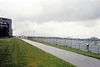
| Black Rock Canal | 42°54′25″N 78°54′07″W / 42.90706°N 78.902053°W | |
Black Rock Canal flows within and parallel to the east shore of the Niagara river near Buffalo, New York, and was built to extend the navigation period in the Niagara River through a greater part of the winter.[9] The canal begins at Buffalo Harbor, on the north-east shore of Lake Erie, then flows north, ending at the Black Rock Lock near the north tip of Unity Island. The canal is buffered from the Niagara River by Bird Island Pier at its south end, and Unity Island at its north end. |  |
| Gould Ditch | 42°55′14″N 78°54′42″W / 42.920689°N 78.911785°W | |
Historic tributary. Once served as a drainage ditch for Gould National Battery plant.[10] | |
| Scajaquada Creek | 42°55′45″N 78°53′57″W / 42.929091°N 78.899056°W | |
Tributary. | 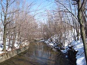 |
| Frenchman's Creek | 42°56′34″N 78°55′39″W / 42.942648°N 78.927391°W | |
Tributary. | |
| Chippawa Channel | 42°57′12″N 78°56′15″W / 42.953344°N 78.937626°W | |
The north-flowing Niagara River bifurcates at the south tip of Grand Island (both sections rejoin at the north tip). "Chippawa Channel" is the river passage on the west side of Grand Island. | |
| Miller Creek | 42°57′19″N 78°58′31″W / 42.955315°N 78.97537°W | |
Tributary. | |
| Tonawanda Channel | 42°57′39″N 78°55′46″W / 42.960757°N 78.929386°W | |
When the Niagara River bifurcates at Grand Island, the east passage—from the south tip of Grand Island, to a point just north of Tonawanda, New York—is the "Tonawanda Channel". | |
| Baker Creek | 42°58′22″N 79°00′29″W / 42.972761°N 79.008039°W | |
Tributary. | |
| Black Creek | 42°58′52″N 79°01′25″W / 42.980999°N 79.023499°W | |
Tributary. | |
| Boyer's Creek | 43°00′07″N 79°01′46″W / 43.00194°N 79.029508°W | |
Tributary. | |
| Two Mile Creek | 43°00′39″N 78°54′24″W / 43.010845°N 78.906555°W | |
Tributary. | |
| Little River (at Tonawanda Island) | 43°01′23″N 78°53′06″W / 43.022926°N 78.884969°W | |
Flows between Tonawanda Island and the New York mainland, within the Tonawanda Channel. | |
| Tonawanda Creek | 43°01′24″N 78°52′54″W / 43.02338°N 78.881707°W | |
Tributary. |  |
| Spicer Creek | 43°01′31″N 78°53′39″W / 43.025279°N 78.894153°W | |
Tributary on Grand Island, New York. | |
| Big Sixmile Creek | 43°01′35″N 79°00′42″W / 43.026494°N 79.011773°W | |
Tributary on Grand Island, New York. | |
| Little Sixmile Creek | 43°01′43″N 79°00′37″W / 43.028502°N 79.010217°W | |
Tributary on Grand Island, New York. | |
| Niagara River Channel | 43°02′09″N 78°53′38″W / 43.035772°N 78.893809°W | |
When the Niagara River bifurcates at Grand Island, the east passage—from a point just north of Tonawanda, New York, to the north tip of Grand Island—is the "Niagara River Channel". |  |
| Gun Creek | 43°02′58″N 78°54′57″W / 43.049455°N 78.915728°W | |
Tributary on Grand Island, New York. | |
| Usshers Creek | 43°03′05″N 79°01′21″W / 43.051282°N 79.022577°W | |
Tributary. | |
| Burnt Ship Creek | 43°03′40″N 78°59′51″W / 43.060987°N 78.997493°W | |
Tributary on Grand Island, New York. | |
| Woods Creek | 43°03′44″N 78°58′37″W / 43.062335°N 78.976958°W | |
Tributary on Grand Island, New York. | 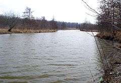 |
| Welland River | 43°03′46″N 79°02′53″W / 43.062711°N 79.047961°W | |
Historic tributary. Became a man-made distributary—from the Niagara River to a point 5 km west—in order to supply water to an intake channel for Sir Adam Beck Hydroelectric Power Stations. | |
| Underwater intake tunnel to Sir Adam Beck Hydroelectric Power Stations | 43°04′02″N 79°03′14″W / 43.067124°N 79.053959°W | |
 | |
| Little River (at Cayuga Island) | 43°04′23″N 78°57′06″W / 43.073167°N 78.951724°W | |
Flows between Cayuga Island and the New York mainland, within the Niagara River Channel. | |
| Cayuga Creek | 43°04′33″N 78°57′46″W / 43.075894°N 78.962753°W | |
Tributary. | |
| Underwater intake for tunnel to Niagara Power Project | 43°04′38″N 79°00′57″W / 43.07725°N 79.015796°W | |
 | |
| Horseshoe Falls | 43°04′38″N 79°04′30″W / 43.077289°N 79.075127°W | |
Located between the Canadian mainland and Goat Island, New York, the Horseshoe Falls is the largest, and most south-western of three parallel waterfalls over-which the Niagara River flows. There is dispute as to whether the Horseshoe Falls lies entirely within Canada (see Niagara Falls#History). | 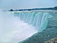 |
| Gill Creek | 43°04′42″N 79°01′33″W / 43.078292°N 79.025838°W | |
Tributary. | |
| Goat Island Channel | 43°04′50″N 79°03′38″W / 43.080612°N 79.060535°W | |
The Niagara River bifurcates at the south-east tip of Goat Island. "Goat Island Channel" is the north-east passage around the island. | 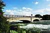 |
| Bridal Veil Falls | 43°05′02″N 79°04′15″W / 43.083781°N 79.070776°W | |
Located between Goat Island and Luna Island, Bridal Veil Falls is the smallest (and middle) of the three parallel waterfalls over-which the Niagara River flows. It is entirely within the US. | 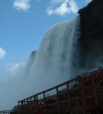 |
| American Falls | 43°05′06″N 79°04′10″W / 43.084866°N 79.069462°W | |
Located between Luna Island and the New York mainland, the American Falls is the most northern and second largest of three parallel waterfalls over-which the Niagara River flows. It is located entirely within the US. |  |
| Muddy Run Falls | 43°06′54″N 79°03′45″W / 43.114972°N 79.06252°W | |
Historic tributary which entered the Niagara River as a waterfall from the top of the Niagara Gorge. Development above Muddy Run Falls destroyed its water supply. | |
| Whirlpool Rapids | 43°06′58″N 79°03′45″W / 43.116006°N 79.062488°W | |
 | |
| Colt's Creek Falls | 43°07′11″N 79°04′19″W / 43.119757°N 79.071929°W | |
Tributary which enters the Niagara River as a waterfall from the top of the Niagara Gorge. The volume was greatly diminished following construction of the canal to Sir Adam Beck Hydroelectric Power Stations. | |
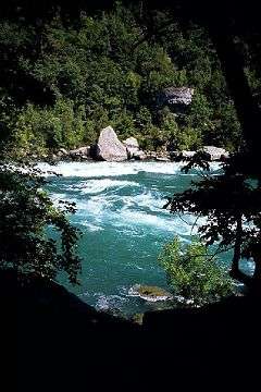
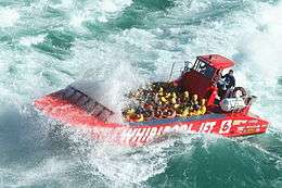
| Niagara Whirlpool | 43°07′13″N 79°04′10″W / 43.120219°N 79.069526°W | |
The Niagara Whirlpool is a natural whirlpool along the Niagara River located along the Canada–US border between New York and Ontario. The whirlpool is located in the Niagara Gorge, downstream from Niagara Falls. The whirlpool's greatest depth is 125 feet (38 m).[11] | |
| Harvie Falls | 43°07′19″N 79°04′28″W / 43.12206°N 79.074311°W | |
Tributary which enters the Niagara River as a waterfall from the top of the Niagara Gorge. The volume was greatly diminished following construction of the canal to Sir Adam Beck Hydroelectric Power Stations. | |
| Devil's Hole Rapids | 43°08′01″N 79°03′03″W / 43.133547°N 79.050901°W | |
 | |
| Bloody Run Falls | 43°08′06″N 79°02′50″W / 43.134987°N 79.047275°W | |
Tributary which enters the Niagara River as a waterfall from the top of the Niagara Gorge. The volume was greatly diminished following construction of Robert Moses State Parkway and other streets above the falls. |  |
| Niagara Power Project | 43°08′35″N 79°02′23″W / 43.142957°N 79.039807°W | |
 | |
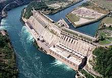
| Sir Adam Beck Hydroelectric Power Stations | 43°08′51″N 79°02′39″W / 43.147419°N 79.04406°W | |
 | |
| Smeaton Falls | 43°09′23″N 79°02′46″W / 43.156275°N 79.045998°W | |
Tributary which enters the Niagara River as a waterfall from the top of the Niagara Gorge. The volume was greatly diminished following the construction of Sir Adam Beck Hydroelectric Power Stations. | 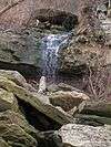 |
| Spring Cave Cascade | 43°09′26″N 79°02′40″W / 43.157348°N 79.044372°W | |
Historic tributary which entered the Niagara River as a cascade from caves in the wall of the Niagara Gorge. Its source was destroyed following construction of the Niagara Power Project. | |
| Fish Creek Falls | 43°09′32″N 79°02′41″W / 43.159018°N 79.04459°W | |
Tributary which enters the Niagara River as a waterfall from the top of the Niagara Gorge. The volume was greatly diminished following the construction of the Niagara Power Project. | |
| Locust Grove Falls | 43°09′33″N 79°02′51″W / 43.159183°N 79.047532°W | |
Tributary which enters the Niagara River as a waterfall from the top of the Niagara Gorge. The volume was greatly diminished following the construction of Sir Adam Beck Hydroelectric Power Stations. | 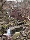 |
| Mouth of Niagara River | 43°15′46″N 79°04′14″W / 43.262722°N 79.070646°W | |
 | |
Islands
Several islands are located on the upper river upriver from the falls:
| Name | Location | Country | Status | Notes |
|---|---|---|---|---|
| Bird Island | Buffalo | |
Filled in | Connected to Unity Island in 1822 as part of improvements to Black Rock harbor.[12] |
| Brother Island | Niagara Falls | |
Located near Niagara Falls and the Three Sisters Islands. | |
| Buckhorn Island | Grand Island | |
Park | Located on the north end of Grand Island. A state park. |
| Cayuga Island | Niagara Falls | |
Residential | Located at the mouth of Cayuga Creek; a residential neighborhood of the city. |
| Cedar Island | |
Filled in | Filled in by the creation of the William Birch Rankine Power Station by Canadian Niagara Power Company in 1905. | |
| Deer Island | Niagara Falls | |
||
| Dufferin Islands | Niagara Falls | |
Park | Man-made islands. Parkland. |
| Frog Island | |
Submerged/reconstructed | Was located in the Upper Niagara River between Motor Island and Strawberry Island. Disappeared due to erosion sometime between 1951 and 1985.[13] Re-created beginning in 2007 as a habitat for fish, waterfowl, and aquatic plants.[14][15] | |
| Goat Island | Niagara Falls | |
Park located at the brink of the American Falls, named by John Stedman in the 1770s; briefly renamed to Iris Island by General Augustus Porter, a United States Commissioner (after the Greek Goddess of the Rainbow). | |
| Goose Island | City of Tonawanda | |
Man-made/filled in | Was located at the confluence of Tonawanda Creek and the Tonawanda Channel of the Niagara River. Existed from 1825, when the Erie Canal was constructed (thereby cutting Goose Island off from the mainland) until the 1940s, when this portion of the canal was filled in. |
| Grand Island | |
Developed | The largest island on the river; includes several parks, but is mostly residential and industrial; originally called Ga-We-Not (Great Island) by the Seneca. | |
| Grass Island | |
Filled in | Filled in during the 1960s to create the Robert Moses Parkway at Point Day. | |
| Green Island | Niagara Falls | |
Originally called Bath Island, it was renamed in the early 1900s for Niagara Reservation Commissioner Andrew H. Green. | |
| Gull Island | Niagara Falls | |
||
| Hogg Island | |
Filled in | Filled in by the creation of the Chippawa Queenston Power Canal in 1917 and finally by the Sir Adam Beck Dam #2 in 1950 by the Hydro Electric Power Commission of Ontario. | |
| Little Beaver Island | Grand Island | |
Park | Located off the south end of Grand Island; part of Beaver Island State Park. |
| Luna Island | Niagara Falls | |
Park | Park located next to Goat Island; originally called Prospect Island |
| Motor Island | Grand Island | |
Park | Also known as Pirates' Island (the name of a private club once located there) and Frog Island (not to be confused with the Frog Island listed above).[16] A New York State Wildlife Management Area. |
| Navy Island | Niagara Falls | |
Park | Designated as a National Historic Park. |
| Rattlesnake Island | Town of Tonawanda | |
Filled in | Was located just south of what is today the South Grand Island Bridge. Was filled in sometime between 1915 [17] and 1927,[18] concurrent with the heavy industrial development of the area. |
| Robinson Island | Niagara Falls | |
Named for daredevil Joel Robinson in 1860. | |
| Ship Island & Brig Island | |
|||
| Strawberry Island | Town of Tonawanda | |
Park | A small island, formerly much larger but diminished by gravel mining and erosion.[19] An undeveloped state park and wildlife preserve.[20] |
| Three Sisters Islands | Niagara Falls | |
Park | Park located next to Goat Island; was originally called Moss Islands and later renamed for the three daughters of War of 1812 United States Army General Parkhurst Whitney (Asenath, Angeline and Celinda Eliza) in 1843. |
| Tonawanda Island | North Tonawanda | |
Developed | Occupied by a marina and several industries. |
| Tower Island | |
Man-made | Man-made island created in 1942 by the US Army Corps of Engineers. | |
| Unity Island | Buffalo | |
Developed | Home to Broderick Park, Unity Island Park, and a waste-water treatment facility. |
| Willow Island | |
Man-made/filled in | Man-made island created in 1759 by Daniel Joncairs and filled in during the 1960s to create the Robert Moses Parkway. | |
Military posts
United States Coast Guard Fort Niagara Station was once a United States Army post. There are no Canadian Coast Guard posts along the river. Fort Mississauga, Fort George and Fort Erie are former British and Canadian military forts (last used 1953, 1965 and 1923 respectively) and are now parks.
Roads
On the Canadian side the Niagara Parkway travels along the River from Lake Ontario to Lake Erie.
![]() NY 18F lines the river on the state side from Fort Niagara to Lewiston.
NY 18F lines the river on the state side from Fort Niagara to Lewiston. ![]() Niagara Scenic Parkway on the state side only travels along the River from the Falls to Lewiston. The remaining river sections (with some interruptions) are covered by the
Niagara Scenic Parkway on the state side only travels along the River from the Falls to Lewiston. The remaining river sections (with some interruptions) are covered by the ![]() LaSalle Expressway,
LaSalle Expressway, ![]() NY 384,
NY 384, ![]() NY 266 and
NY 266 and ![]()
![]() I-190 (Niagara Thruway) / New York Thruway.
I-190 (Niagara Thruway) / New York Thruway.
See also
- List of international border rivers
- List of New York rivers
- List of Ontario rivers
- Whirlpool Aero Car
References
- 1 2 "Facts & Figures - Niagara Parks, Niagara Falls, Ontario, Canada" (online). Retrieved May 30, 2007.
- ↑ Water Resources Data New York Water Year 2003, Volume 3: Western New York, USGS
- ↑ Bruce Trigger, The Children of Aataentsic (McGill-Queen's University Press, Kingston and Montreal,1987, ISBN 0-7735-0626-8), p. 95.
- ↑ Stewart, George R. (1967) Names on the Land. Boston: Houghton Mifflin Company; p. 83.
- ↑ Mobot.org
- ↑ Hennepin, Louis. A New Discovery of a Vast Country in America. Chicago: A.C. McClurg & Co., 1903. Accessed December 8, 2008.
- ↑ Porter, Peter (1914). Landmarks of the Niagara Frontier. The Author.
- ↑ Electricity and its Development at Niagara Falls. University at Buffalo, June 2004. Accessed December 8, 2008.
- ↑ "Black Rock Canal". Encyclopædia Britannica. Encyclopædia Britannica Online. Retrieved Jan. 3, 2013.
- ↑ "Chemicals of Concern in the Niagara River Tributaries - 1988-89". Ontario Ministry of Environment and Energy, Queen's Printer for Ontario, 1993.
- ↑ "Whirlpool State Park - Niagara Falls, New York". Nyfalls.com. 1935-09-13. Retrieved 2011-08-20.
- ↑ http://www.buffalonian.com/history/industry/waterways/WATERWAYS3.html
- ↑ http://niagara.nypa.gov/EcologicalStandingCommittee
- ↑ Pignataro, T.J. (August 22, 2015). "Restoration of Frog Island hailed as Buffalo comeback story". The Buffalo News. Retrieved April 10, 2016.
- ↑ http://buffalorising.com/2013/10/frog-island-habitat-restoration/
- ↑ Island Dispatch, 16th June 1989
- ↑ http://www.historicmapworks.com/Map/US/38766/Tonawanda+Town+8++Riverside+Land+Company/Buffalo+1915+Vol+3+Suburban/New+York/
- ↑ http://www.erie.gov/aerials/1920s/atlases/book8/html/b8_e26.html
- ↑ "Strawberry Island - Motor Island Shallows Coastal Fish & Wildlife Habitat Assessment Form" (PDF). NYS Department of State. October 15, 1987. Retrieved April 10, 2016.
- ↑ "Grand Island: NYPA approves contract for Strawberry Island wetland restoration, habitat improvement". Niagara Frontier Publications. March 30, 2015. Retrieved April 11, 2016.
- Tiplin, Albert H.; Seibel, George A. and Seibel, Olive M. (1988) Our romantic Niagara: a geological history of the river and the falls Niagara Falls Heritage Foundation, Niagara Falls, Ontario, Canada, ISBN 0-9690457-2-7
Further reading
- Hulbert, A. B. (1908). The Niagara River. New York: G.P. Putnam's Sons.
External links
| Wikimedia Commons has media related to Niagara River. |
| Wikisource has the text of the 1911 Encyclopædia Britannica article Niagara. |
- Views of the Niagara River Niagara Falls Public Library (Ont.)
- Digital Images of the Islands of the Niagara River Niagara Falls Public Library (Ont.)
- Buffalo Niagara Riverkeeper
- Niagara Falls The Islands A History of the Niagara River Islands
- Niagara River from The Canadian Encyclopedia
Coordinates: 43°04′41″N 79°04′37″W / 43.078°N 79.077°W
Great Lakes of North America | ||
|---|---|---|
| Main lakes | 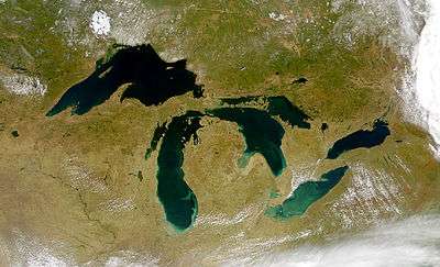 | |
| Secondary lakes | ||
| Bays and Waterways |
| |
| Islands | ||
| Historic geology | ||
| Government | ||
| Related topics |
| |