Newark, Delaware
| Newark, Delaware | |
|---|---|
| city | |
| City of Newark | |
|
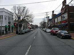
Main Street is the commercial heart of Newark. It is adjacent to the University of Delaware. | |
 Location in New Castle County and the state of Delaware. | |
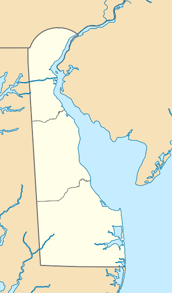 Newark  Newark Location within the state of Delaware | |
| Coordinates: 39°40′45″N 75°45′29″W / 39.67917°N 75.75806°WCoordinates: 39°40′45″N 75°45′29″W / 39.67917°N 75.75806°W | |
| Country |
|
| State |
|
| County | New Castle |
| Founded | 1694 |
| Incorporated | 1758 |
| Government | |
| • Mayor | Polly Sierer |
| Area | |
| • Total | 3.6 ha (8.9 acres) |
| • Land | 3.6 ha (8.9 acres) |
| • Water | 0.0 ha (0.0 acres) |
| Population (2010) | |
| • Total | 31,454 |
| • Density | 1,235.0/km2 (3,198.6/sq mi) |
| Time zone | EST (UTC-5) |
| • Summer (DST) | EDT (UTC-4) |
| ZIP codes | 19702, 19711-19718, 19725 |
| Area code | 302 |
| Website | City of Newark |
Newark (/ˈnuːɑːrk/ NEW-ark)[note 1] is a small city in New Castle County, Delaware, 12 miles (19 km) west-southwest of Wilmington. According to the 2010 Census, the population of the city is 31,454.[1] Newark is the home of the University of Delaware.
History
Newark was founded by Scots-Irish and Welsh settlers in 1694. The town was officially established when it received a charter from George II of Great Britain in 1758.
Schools have played a significant role in the history of Newark. A grammar school, founded by Francis Alison in 1743, moved from New London, Pennsylvania to Newark in 1765, becoming the Newark Academy. Among the first graduates of the school were three signers of the Declaration of Independence: George Read, Thomas McKean, and James Smith. Two of which, Read and McKean, went on to have schools named after them in the state of Delaware: George Read Middle School[2] and Thomas McKean High School.
During the American Revolutionary War, British and American forces clashed outside Newark at the Battle of Cooch’s Bridge. Tradition holds that the Battle of Cooch's Bridge was the first instance of the Stars and Stripes being flown in battle.[3]
The state granted a charter to a new school in 1833, which was called Newark College. Newark Academy and Newark College joined together in the following year, becoming Delaware College. The school was forced to close in 1859, but was resuscitated eleven years later under the Morrill Act when it became a joint venture between the State of Delaware and the school's Board of Trustees. In 1913, pursuant to legislative Act, Delaware College came into sole ownership of the State of Delaware. The school would be renamed the University of Delaware in 1921.
Newark received a license from King George II to hold semi-annual fairs and weekly markets for agricultural exchange in 1758. A paper mill, the first sizable industrial venture in Newark, was created around 1798.[4] This mill, eventually known as the Curtis Paper Mill, was the oldest paper mill in the United States until its closing in 1997. Methodists built the first church in 1812 and the railroad arrived in 1837.
One of Newark's major sources of employment and revenue was the Chrysler Newark Assembly plant which was built in 1951. Jamaican reggae star, Bob Marley worked as an assembly-line worker at the plant during his short stint in Delaware in the 1960s.[5] Originally constructed to build tanks for the US Army, the plant was 3.4 million square feet in size. It employed 1,100 employees in 2008 which was down from 2,115 in 2005. This turn was due largely to the decline of sales of the Durango and Aspen vehicle models that were being produced. The plant stood for more than 50 years, providing jobs and revenue to the state of Delaware. The factory produced a wide variety of automobile models during its run. The plant was closed in late 2008 due to the recession and limited demand for larger cars.[6][7]
Geography
Newark is located at 39°40′45″N 75°45′29″W / 39.67917°N 75.75806°W (39.679111, −75.758040).[8] It is located directly east of the Maryland state line, adjacent to the unincorporated community of Fair Hill, and is less than a mile south of the tripoint where Delaware, Maryland, and Pennsylvania meet, known as the Twelve-Mile Circle.
According to the United States Census Bureau, the city has a total area of 8.9 square miles (23 km2), all of it land. Originally surrounded by farmland, Newark is now surrounded by housing developments in some directions, although farmland remains just over the state lines in Maryland and Pennsylvania. To the north and west are small hills, but south and east of the city, the land is flat (part of Newark falls in the Piedmont geological region and part of the city is in the Coastal Plain geological region, as is the majority of the land in the State of Delaware).
Parks and natural areas
Despite the fact that Newark is located roughly halfway between Philadelphia (approximately 45 miles (72 km) away) and Baltimore (approximately 55 miles (89 km) away) and is part of densely populated New Castle County, there is a large amount of public parkland—over 12,000 acres (49 km2) – surrounding the city. To the south is Iron Hill Park (part of the New Castle County Park System), to the west (in Cecil County, Maryland) is Fair Hill Natural Resources Management Area, and to the North is White Clay Creek State Park and White Clay Creek Preserve (in Chester County, Pennsylvania). Also nearby is Middle Run Valley Natural Area, which is part of the New Castle County Park System. These parks provide ample hiking, mountain biking, and horse back riding opportunities. Fair Hill Natural Resources Management Area and much of White Clay Creek State Park consist of land formerly owned by the Du Pont family that was later ceded to the states of Maryland and Delaware, respectively.
 The old Bank of Newark Building, 102 E. Main
 Rhodes Pharmacy, 36 E. Main
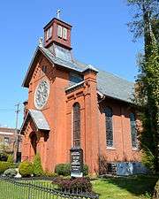 St. John the Baptist Church, 200E. Main
Demographics
| Historical population | |||
|---|---|---|---|
| Census | Pop. | %± | |
| 1860 | 787 | — | |
| 1870 | 915 | 16.3% | |
| 1880 | 1,148 | 25.5% | |
| 1890 | 1,191 | 3.7% | |
| 1900 | 1,213 | 1.8% | |
| 1910 | 1,913 | 57.7% | |
| 1920 | 2,183 | 14.1% | |
| 1930 | 3,899 | 78.6% | |
| 1940 | 4,502 | 15.5% | |
| 1950 | 6,731 | 49.5% | |
| 1960 | 11,404 | 69.4% | |
| 1970 | 21,298 | 86.8% | |
| 1980 | 25,247 | 18.5% | |
| 1990 | 25,098 | −0.6% | |
| 2000 | 28,547 | 13.7% | |
| 2010 | 31,454 | 10.2% | |
| Est. 2015 | 33,817 | [9] | 7.5% |
As of the census[11] of 2000, there were 28,547 people, 8,989 households, and 4,494 families residing in the city. The population density was 3,198.6 people per square mile (1,235.7/km²). There were 9,294 housing units at an average density of 1,041.4 per square mile (402.3/km²). The racial makeup of the city was 87.29% White, 6.00% Black, 0.16% Native American, 4.07% Asian, 0.05% Pacific Islander, 0.86% from other races, and 1.57% from two or more races. Hispanic or Latino of any race were 2.53% of the population. 16.8% were of Irish, 13.5% Italian, 13.4% German, 10.2% English and 5.1% Polish ancestry according to Census 2000.
Of the 8,989 households, 20.7% have children under the age of 18 living with them, 40.5% were married couples living together, 7.2% had a female householder with no husband present, and 50.0% were non-families. 27.2% of all households were made up of individuals and 9.3% had someone living alone who was 65 years of age or older. The average household size was 2.43 and the average family size was 2.91.
In the city, the population was spread out with 12.5% under the age of 18, 43.6% from 18 to 24, 19.8% from 25 to 44, 14.9% from 45 to 64, and 9.1% who were 65 years of age or older. The median age was 23 years. For every 100 females, there were 85.2 males. For every 100 females age 18 and over, there were 82.3 males.
The median household income was $48,758, and the median family income was $75,188. Males had a median income of $45,813 versus $33,165 for females. The per capita income for the city was $20,376. About 4.1% of families and 20.1% of the population were below the poverty line, including 7.0% of those under age 18 and 7.1% of those age 65 or over.
Education
Public schools
Public education in Newark is managed by the Christina School District and the New Castle County Vocational-Technical School District. The Christina School District manages public education for Newark and environs and parts of Wilmington, Delaware.
Christina School District schools located within or near the city limits are:
- Downes Elementary School (grades K-5)
- Gallaher Elementary School (grades K-5)
- McVey Elementary School (grades K-5)
- Jennie E. Smith Elementary School (grades K-5)
- West Park Place Elementary School (grades K-5)
- Shue-Medill Middle School (grades 6-8)
- Christiana High School (grades 9-12)
- Glasgow High School (grades 9-12)
- Newark High School (grades 9-12)
- Delaware School for the Deaf (grades K-12)
Charter schools
Newark Charter School is a state-chartered school offering grades K-12.
University of Delaware
Newark is home to the University of Delaware (UD). The school has programs in a broad range of subjects, but is probably best known for its business, chemical engineering, chemistry and biochemistry programs, drawing from the historically strong presence of the nation's chemical and pharmaceutical industries in the state of Delaware. In 2006, UD's graduate engineering program was ranked number 11 in the nation by The Princeton Review.[12] Newark's Mainstreet is popular among both the University of Delaware students as well as the residents of Newark, offering many restaurant and boutique options.
Sports
Newark is a recognized center of US and international figure skating, mostly due to the many national, world, and Olympic champions (including many foreign nationals) that have trained at the University of Delaware Figure Skating Club (an independent club operating within UD facilities) and at The Pond Ice Rink. In 2009, Sporting News ranked Newark 192 in its list of the 400 Best Sports Cities.[13]
The University of Delaware offers 21 varsity sports, which compete in the NCAA Division I. The athletic teams at Delaware are known as the Fightin' Blue Hens, named after the Blue Hen of Delaware, the state bird of Delaware.[14] The official mascot of the University of Delaware is YouDee.
The Delaware 87ers are a professional basketball team that plays in the NBA Development League, or "D-League". The team is the affiliate of the Philadelphia 76ers and play their home games at the Bob Carpenter Center in Newark on the University of Delaware campus.
Transportation
Several highways pass through the Newark area. Interstate 95, the main interstate highway through the northeast urban seaboard corridor, passes to the south of Newark on the tolled Delaware Turnpike. Delaware Route 896 serves as the main north-south route through the Newark area, interchanging with I-95 to the south and continuing north through the city, bypassing the University of Delaware campus to the west. Delaware Route 72 runs north-south, bypassing Newark to the east. Major east–west highways through the Newark area include Delaware Route 273, which passes through the heart of Newark, Delaware Route 2 (Kirkwood Highway), which heads east to Wilmington, Delaware Route 4, which bypasses Newark to the south on the Christiana Parkway, and Delaware Route 279, which heads southwest towards Elkton, Maryland.
The closest airport to Newark is the Wilmington Airport in New Castle. The largest airport from Newark that provides full domestic and international service is Philadelphia International Airport.
Newark has a Rail Station (Map, via Google Maps) located to the south of downtown near the University of Delaware campus that is serviced by both SEPTA and Amtrak on the Northeast Corridor. Newark is the last stop on the SEPTA Wilmington/Newark Line, one of the farthest points out on the system. SEPTA service to Newark involves 4 trains in both directions during the morning and evening rush hours, weekdays only. There is limited Amtrak service in Newark with one to two trains per day toward New York, and one train per day toward Washington. Newark is also served by two freight railroads: Norfolk Southern, which provides freight service on the Northeast Corridor line and has a branch that splits to the south to run along the Delmarva Peninsula, and CSX, which passes through the northern part of Newark.
Newark is served by DART First State buses, routes No. 6, 16, 31, 33, 34, 39, 59, 65, and 302, providing service to Wilmington, the Christiana Mall, Elkton, MD, and Dover. Most routes travel through the university campus and also stop at the rail station. There is also a Unicity bus, run jointly through the city and the University, free for everyone to ride, which acts as a community circulator. The University of Delaware also operates a bus system, available and free to all students and those associated with the university.
Notable people
- Ann Althouse, law professor and blogger, University of Wisconsin Law School
- Joe Biden, former Delaware Senator; 47th Vice President of the United States
- Tarzan Cooper, professional basketball player
- Harry Coover, inventor
- Dave Douglas, golfer
- Tom Douglas, award-winning Seattle chef
- Joe Flacco, former University of Delaware football player; current Baltimore Ravens quarterback
- Richard Howell, Governor of New Jersey
- K. C. Keeler, former University of Delaware football coach
- Judith LeClair, musician
- Jack A. Markell, Incumbent Governor of Delaware
- Arthur A. Morrell, Louisiana politician; former resident of Newark
- M. A. Muqtedar Khan, Muslim-American intellectual and commentator
- David Roselle, former President of the University of Delaware
- Dave Sheridan, actor, writer, producer
- Harold "Tubby" Raymond College Hall of Fame football coach
- Johnny Weir, U.S. figure skating champion
- Vic Willis, Hall of Fame baseball player
- Shien Biau Woo, former Lt. Governor
Media
Radio
- WVUD/91.3: University of Delaware
Magazine
Newspaper
See also
- Tri-State Bird Rescue and Research
- National Register of Historic Places listings in northern New Castle County, Delaware
Notes
- ↑ Not /ˈnuːərk/ NEW-ərk as in Newark, New Jersey.
References
- ↑ "The Delaware Census State Data Center". Stateplanning.delaware.gov. Retrieved August 20, 2011.
- ↑ "George Read | A middle school serving 6-8th grade in New Castle, Delaware". www.colonialschooldistrict.org. Retrieved 2016-01-24.
- ↑ Nelson, Ralph (Fall 2003). "The Battle of Cooch's Bridge" (PDF). SAR Magazine. Archived from the original (PDF) on August 9, 2014.
- ↑ Haugen, Øyvind. "The Curtis Paper Mill". Paperindustryweb.com
- ↑ "Marley worked 'Night Shift' in Delaware". The News Journal. Retrieved 2016-01-24.
- ↑ "Chrysler's Newark Plant (Delaware)". Allpar.com. Retrieved September 10, 2012.
- ↑ "University Library announces oral history of Chrysler's Newark Assembly Plant". University of Delaware. March 19, 2012. Retrieved September 10, 2012.
- ↑ "US Gazetteer files: 2010, 2000, and 1990". United States Census Bureau. 2011-02-12. Retrieved 2011-04-23.
- ↑ "Annual Estimates of the Resident Population for Incorporated Places: April 1, 2010 to July 1, 2015". Retrieved July 2, 2016.
- ↑ "Census of Population and Housing". Census.gov. Retrieved June 4, 2015.
- ↑ "American FactFinder". United States Census Bureau. Retrieved 2008-01-31.
- ↑ Thomas, Neil. "Graduate engineering at UD ranked No. 11 nationally". Udaily. The University of Delaware, Office of Public Relations. Archived from the original on July 22, 2010.
- ↑ "Best Sports City: The list". The Sporting News. October 12, 2009. Archived from the original on May 29, 2010. Retrieved June 22, 2010.
- ↑ "UD Athletics". University of Delaware. Retrieved August 13, 2012.
External links
| Wikivoyage has a travel guide for Newark, Delaware. |
| Wikisource has the text of a 1905 New International Encyclopedia article about Newark, Delaware. |
- City of Newark
- Brief History of Newark
- Newark History
- A History of Newark, from 1757 to 1888 from Thomans J. Scharf's Chapter on White Clay Creek Hundred in History of Delaware, 1609–1888.
- Official Delaware Tourism Website's list of Newark Attractions
- Newark Housing Authority
- Our Newark Delaware Website
Dover (capital) | ||
| Topics |
|  |
| Society |
| |
| Cities | ||
| Towns |
| |
| Counties | ||
| Counties | 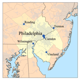 | |
|---|---|---|
| Major cities | ||
| Cities and towns 50k-99k | ||
| Cities and towns 30k-50k | ||