New Zealand State Highway 49
| ||||
|---|---|---|---|---|
| Route information | ||||
| Maintained by New Zealand Transport Agency | ||||
| Length: | 36.2 km (22.5 mi) | |||
| Major junctions | ||||
| West end: |
| |||
| East end: |
| |||
| Location | ||||
| Primary destinations: | Ohakune | |||
| Highway system | ||||
| ||||

State Highway 49 (SH 49) is a New Zealand State Highway, linking SH 4 and SH 1, via the tourist town of Ohakune. It forms the southern part of the ring road surrounding Tongariro National Park and provides access to the southern side of Mount Ruapehu and the Turoa skifield. It roughly follows the North Island Main Trunk railway.
SH 49, along with SH 4, 47, and 46, is used as an alternative route to SH 1 and the Desert Road, and is well used when the Desert Road is closed due to snow.
SH 49 lies entirely within the Ruapehu District.
Route

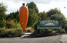

SH 49 leaves SH 4 at Tohunga Junction, some eight kilometres north of Raetihi, and heads southeast across rolling hills to the tourist town of Ohakune. Following Ohakune's main street, the road continues southeast out of the township, passing Ohakune's famous giant carrot.
SH 49 continues southeast across rolling hills, running broadly in the same direction as the North Island Main Trunk. It passes the rural villages of Rangataua and Karioi, before meeting the railway line at the Whangaehu River at Tangiwai. The bridge here has flashing lighs and gates to block off the road in case of a lahar from Mount Ruapehu's crater lake. To the side of the bridge is the Tangiwai memorial, erected to remember the 151 people who died in the Tangiwai disaster when a Wellington to Auckland express train plunged into the river following a lahar on 24 December 1953.
After crossing the Whangaehu River, and the railway line, SH 49 turns east for several kilometres, before turning south into Waiouru. At Waiouru, SH 49 ends at the intersection with SH 1.
Spur
SH 49 used to have one spur; SH 49A. It deviated from SH 49 at Ohakune, and ran west to Raetihi, where it terminated at State Highway 4. SH 49A was revoked in 1991-92.
Major intersections
The highway lies entirely within the Ruapehu District.
| Location | km | jct | Destinations | Notes |
|---|---|---|---|---|
| Tohunga Junction | 0 | |
|
SH 49 begins |
| Ohakune | |
Goldfinch Street – Turoa skifield | ||
| |
Raehiti Ohakune Road – Raetihi | Former SH 49A | ||
| Tangiwai | 29 | |
Whangaehu River | |
| Waiouru | 38 | |
|
SH 49 ends |
See also
References
External links
| National | ||
|---|---|---|
| North Island |
| |
| South Island | ||
| Former state highways | ||
| Touring routes |
| |