Nevada State Route 231
| ||||
|---|---|---|---|---|
| Angel Lake Road | ||||
 | ||||
| Route information | ||||
| Maintained by NDOT | ||||
| Length: | 11.600 mi[1] (18.668 km) | |||
| Existed: | 1976 – present | |||
| Major junctions | ||||
| South end: | Angel Lake | |||
| North end: |
| |||
| Highway system | ||||
| ||||

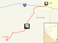
State Route 231 (SR 231) is an unsigned state highway in Elko County, Nevada, United States. Known as Angel Lake Road, the highway connects Angel Lake to the town of Wells. SR 231 is a Nevada Scenic Byway.
Route description
SR 231 begins at the Angel Lake fee booth, providing access to the lake and nearby picnic and campground areas. From there, the highway heads in a general eastward direction, descending through switchbacks along the east side of the East Humboldt Range. Once traveling about 5.5 miles (8.9 km) to clear of the mountains, the road turns more sharply to the north. The final 1.5 miles (2.4 km) sees the route turn more directly eastward to enter the town of Wells. SR 231 comes to its northern terminus at the intersection of Angel Lake Road and Humboldt Avenue (SR 223) in Wells, just south of Interstate 80.[1][2] Angel Lake Road may be closed to travel during winters.
History
_in_Elko_County_in_Nevada.jpg)
Angel Lake Road became a state highway on July 1, 1976.[3]
State Route 231 was designated a Nevada Scenic Byway on June 30, 1995.[4]
Major intersections
The entire route is in Elko County.
| Location | mi | km | Destinations | Notes | |
|---|---|---|---|---|---|
| Angel Lake | 0.00 | 0.00 | Angel Lake access | ||
| Wells | 11.60 | 18.67 | TO I-80 | ||
| 1.000 mi = 1.609 km; 1.000 km = 0.621 mi | |||||
See also
 Nevada portal
 U.S. Roads portal
References
- 1 2 Nevada Department of Transportation (October 2012). "State Maintained Highways of Nevada: Descriptions and Maps (Quarter 3 Update)". Retrieved October 21, 2012.
- ↑ Google (October 21, 2012). "Overview of SR 231" (Map). Google Maps. Google. Retrieved October 21, 2012.
- ↑ Nevada State Maintained Highways: Descriptions, Index and Maps. Nevada Department of Transportation. 2001.
- ↑ "Nevada Scenic Byway". Nevada Department of Transportation. Retrieved October 22, 2012.
External links
 Media related to Nevada State Route 231 at Wikimedia Commons
- Nevada Department of Transportation - Angel Lake Photo Gallery