Nevada State Route 223
| ||||
|---|---|---|---|---|
|
Interstate 80 Business Humboldt Avenue & Sixth Street | ||||
|
Nevada State Route 223, highlighted in red | ||||
| Route information | ||||
| Length: | 2.010 mi[1] (3.235 km) | |||
| Existed: | 1976 – present | |||
| Major junctions | ||||
| West end: |
| |||
| East end: |
| |||
| Highway system | ||||
| ||||


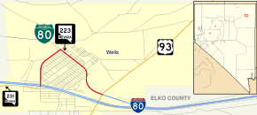
State Route 223 (SR 223) is a state highway in Elko County, Nevada, United States. Co-signed with Interstate 80 Business (I-80 Bus.), it serves the town of Wells.
Route description
_near_6th_Street_in_Wells%2C_Nevada.JPG)
State Route 223 begins at the intersection of Humboldt Avenue and Angel Lake Road (SR 231) in western Wells. From there, the highway follows Humboldt Avenue northward, crossing underneath Interstate 80 (I-80), curving easterly as the road borders residential areas of the town. After about 0.9 miles (1.4 km), Humboldt Avenue intersects Sixth Street. SR 223 turns southeasterly to follow Sixth Street for about 1.1 miles (1.8 km) before reaching its terminus at the intersection with U.S. Route 93.[1][2]
Sixth Street continues east to intersect a westbound off ramp from I-80, which completes the I-80 Bus. Loop.
_near_Wells_Avenue_in_Wells%2C_Nevada.jpg)
History
Prior to 1976, the portion of SR 223 along Sixth Street was part of old State Route 1 and U.S. Route 40.[1]
Major intersections
The entire route is in Wells, Elko County.
| mi | km | Destinations | Notes | ||
|---|---|---|---|---|---|
| 0.00 | 0.00 | Angel Lake Road (SR 231) | |||
| 1.000 mi = 1.609 km; 1.000 km = 0.621 mi | |||||
See also
 Nevada portal
 U.S. Roads portal
References
| Wikimedia Commons has media related to Nevada State Route 223. |
- 1 2 3 Nevada Department of Transportation (October 2012). "State Maintained Highways of Nevada: Descriptions and Maps (Quarter 3 Update)". Retrieved October 21, 2012.
- ↑ Google (October 26, 2012). "Overview of SR 223" (Map). Google Maps. Google. Retrieved October 26, 2012.