Neighborhoods of Vilnius
Neighborhoods of Vilnius (Lithuanian: Vilniaus seniūnijos) are administrative districts of Vilnius City Municipality.
List
Elderships, a statewide administrative division, function as municipal districts. The 21 elderships are based on neighbourhoods:
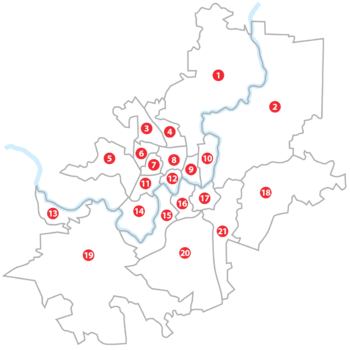
Map of Vilnius neighborhoods. Numbers on the map correspond with numbers in the list
| Neighborhoods | Area (km2)[1] | Pop. (2001)[1] | Density (2001)[1] | |
|---|---|---|---|---|
| 1 | Verkiai | 56.0 | 30,856 | 551.0 |
| 2 | Antakalnis | 77.2 | 39,697 | 514.2 |
| 3 | Pašilaičiai | 7.9 | 25,674 | 3,249.9 |
| 4 | Fabijoniškės | 5.9 | 36,644 | 6,210.8 |
| 5 | Pilaitė | 13.9 | 15,996 | 1,150.8 |
| 6 | Justiniškės | 3.0 | 30,958 | 10,319.3 |
| 7 | Viršuliškės | 2.6 | 16,250 | 6,250.0 |
| 8 | Šeškinė | 4.6 | 36,604 | 7,957.4 |
| 9 | Šnipiškės | 3.1 | 19,321 | 6,232.6 |
| 10 | Žirmūnai | 5.7 | 47,410 | 8,317.5 |
| 11 | Karoliniškės | 3.7 | 31,175 | 8,425.7 |
| 12 | Žvėrynas | 2.6 | 12,188 | 4,687.7 |
| 13 | Grigiškės | 7.0 | 11,617 | 1,659.6 |
| 14 | Lazdynai | 9.9 | 32,164 | 3,248.9 |
| 15 | Vilkpėdė | 10.8 | 24,749 | 2,291.6 |
| 16 | Naujamiestis | 4.9 | 27,892 | 5,692.2 |
| 17 | Senamiestis | 4.4 | 21,022 | 4,777.7 |
| 18 | Naujoji Vilnia | 38.6 | 32,775 | 849.1 |
| 19 | Paneriai | 84.8 | 8,909 | 105.1 |
| 20 | Naujininkai | 37.6 | 33,457 | 889.8 |
| 21 | Rasos | 16.3 | 13,054 | 800.9 |
References
External links
| Wikimedia Commons has media related to Subdivisions of Vilnius. |
- (Lithuanian) Official site of the Vilnius City Municipality
This article is issued from Wikipedia - version of the 11/6/2015. The text is available under the Creative Commons Attribution/Share Alike but additional terms may apply for the media files.