| [3] |
Name on the Register |
Image |
Date listed[4] |
Location |
City or town |
Description |
|---|
| 1 |
Avery Street Historic District |
|
000000001986-04-15-0000April 15, 1986
(#86000849) |
Roughly bounded by Nineteenth, Spring and Quincy, Eighth, and Market Sts.
39°16′15″N 81°33′18″W / 39.270833°N 81.555000°W / 39.270833; -81.555000 (Avery Street Historic District) |
Parkersburg |
|
| 2 |
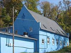
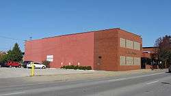
Bethel AME Church |
|
000000001998-10-08-0000October 8, 1998
(#82001767) |
820 Clay St.
39°15′58″N 81°33′18″W / 39.266111°N 81.555000°W / 39.266111; -81.555000 (Bethel AME Church) |
Parkersburg |
Demolished
|
| 3 |
Bethel Presbyterian Church |
Upload image |
000000002014-03-31-0000March 31, 2014
(#14000107) |
7132 Old St. Marys Pike
39°19′57″N 81°25′18″W / 39.332546°N 81.421553°W / 39.332546; -81.421553 (Bethel Presbyterian Church) |
Waverly |
|
| 4 |
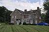
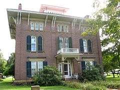
W. H. Bickel Estate |
|
000000002004-02-11-0000February 11, 2004
(#04000027) |
Number One Bickel Mansion Dr.
39°14′52″N 81°35′17″W / 39.247778°N 81.588056°W / 39.247778; -81.588056 (W. H. Bickel Estate) |
Parkersburg |
|
| 5 |
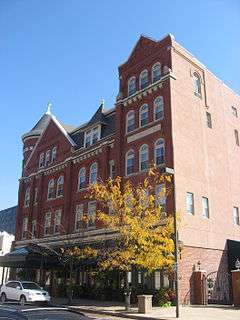
Blennerhassett Hotel |
|
000000001982-12-10-0000December 10, 1982
(#82001768) |
316 Market St.
39°15′54″N 81°33′42″W / 39.265000°N 81.561667°W / 39.265000; -81.561667 (Blennerhassett Hotel) |
Parkersburg |
|
| 6 |
Blennerhassett Island Historic District |
|
000000001972-09-07-0000September 7, 1972
(#72001294) |
On the Ohio River, 1.7 miles south of Parkersburg
39°16′19″N 81°37′12″W / 39.271944°N 81.62°W / 39.271944; -81.62 (Blennerhassett Island Historic District) |
Parkersburg |
|
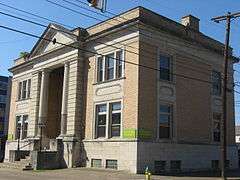
| 7 |
Carnegie Library |
|
000000001982-10-08-0000October 8, 1982
(#82001769) |
725 Green St.
39°15′56″N 81°33′22″W / 39.265556°N 81.556111°W / 39.265556; -81.556111 (Carnegie Library) |
Parkersburg |
|
| 8 |
Case House |
|
000000001982-10-08-0000October 8, 1982
(#82001770) |
710 Ann St.
39°16′09″N 81°33′33″W / 39.269167°N 81.559167°W / 39.269167; -81.559167 (Case House) |
Parkersburg |
Demolished
|
| 9 |
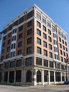
Citizens National Bank |
|
000000001982-10-08-0000October 8, 1982
(#82001772) |
219 4th St.
39°15′56″N 81°33′42″W / 39.265556°N 81.561667°W / 39.265556; -81.561667 (Citizens National Bank) |
Parkersburg |
|
| 10 |
Cook House |
|
000000001978-06-07-0000June 7, 1978
(#78002812) |
1301 Murdoch Ave.
39°16′29″N 81°33′20″W / 39.274722°N 81.555556°W / 39.274722; -81.555556 (Cook House) |
Parkersburg |
|
| 11 |
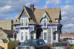
Henry Cooper House |
|
000000001986-02-06-0000February 6, 1986
(#86000828) |
Park Ave.
39°16′18″N 81°31′48″W / 39.271667°N 81.530000°W / 39.271667; -81.530000 (Henry Cooper House) |
Parkersburg |
|
| 12 |
Elks Club |
|
000000001982-10-08-0000October 8, 1982
(#82001773) |
515 Juliana St.
39°16′02″N 81°33′39″W / 39.267222°N 81.560833°W / 39.267222; -81.560833 (Elks Club) |
Parkersburg |
Demolished
|
| 13 |
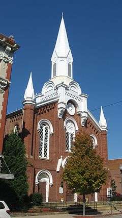
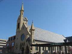
First Baptist Church |
|
000000001982-12-10-0000December 10, 1982
(#82001774) |
813 Market St.
39°16′05″N 81°33′25″W / 39.268056°N 81.556944°W / 39.268056; -81.556944 (First Baptist Church) |
Parkersburg |
|
| 14 |
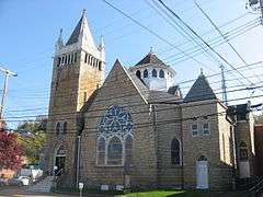
First Presbyterian Church/Calvary Temple Evangelical Church |
|
000000001982-12-10-0000December 10, 1982
(#82001775) |
946 Market St.
39°16′06″N 81°33′18″W / 39.268333°N 81.555000°W / 39.268333; -81.555000 (First Presbyterian Church/Calvary Temple Evangelical Church) |
Parkersburg |
|
| 15 |
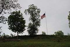
Fort Boreman |
|
000000002003-04-17-0000April 17, 2003
(#02001690) |
Overlooking the confluence of the Little Kanawha and Ohio Rivers[5]
39°15′42″N 81°34′07″W / 39.261618°N 81.56848°W / 39.261618; -81.56848 (Fort Boreman) |
Parkersburg |
|
| 16 |
Gould House/Greater Parkersburg Chamber of Commerce |
|
000000001982-10-08-0000October 8, 1982
(#82001776) |
720 Juliana St.
39°16′05″N 81°33′29″W / 39.268056°N 81.558056°W / 39.268056; -81.558056 (Gould House/Greater Parkersburg Chamber of Commerce) |
Parkersburg |
|
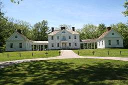
| 17 |
Henderson Hall Historic District |
|
000000001986-04-17-0000April 17, 1986
(#86000811) |
CR 21/2 off WV 14
39°22′40″N 81°28′58″W / 39.377778°N 81.482778°W / 39.377778; -81.482778 (Henderson Hall Historic District) |
Williamstown |
|
| 18 |
House at 10th and Avery Streets |
|
000000001982-12-10-0000December 10, 1982
(#82001777) |
10th and Avery Sts.
39°16′10″N 81°33′12″W / 39.269444°N 81.553333°W / 39.269444; -81.553333 (House at 10th and Avery Streets) |
Parkersburg |
|
| 19 |
Jackson Memorial Fountain |
|
000000001984-08-23-0000August 23, 1984
(#84003686) |
Park Ave. and 17th St.
39°16′11″N 81°31′55″W / 39.269722°N 81.531944°W / 39.269722; -81.531944 (Jackson Memorial Fountain) |
Parkersburg |
|
| 20 |
Julia-Ann Square Historic District |
|
000000001977-05-24-0000May 24, 1977
(#77001380) |
Both sides of Juliana and Ann Sts. from cemetery to 9th St.
39°16′16″N 81°33′21″W / 39.271111°N 81.555833°W / 39.271111; -81.555833 (Julia-Ann Square Historic District) |
Parkersburg |
|
| 21 |
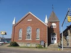
Henry Logan Memorial AME Church |
|
000000001982-12-16-0000December 16, 1982
(#82001778) |
Ann and 6th Sts.
39°16′06″N 81°33′41″W / 39.268333°N 81.561250°W / 39.268333; -81.561250 (Henry Logan Memorial AME Church) |
Parkersburg |
|
| 22 |
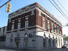
Masonic Temple |
|
000000001982-10-08-0000October 8, 1982
(#82001779) |
900 Market St.
39°16′04″N 81°33′22″W / 39.267778°N 81.556111°W / 39.267778; -81.556111 (Masonic Temple) |
Parkersburg |
|
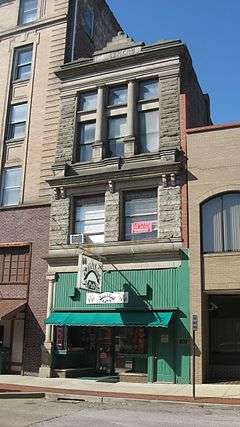
| 23 |
Mather Building/Franklin & DeHaven Jewelers |
|
000000001982-10-08-0000October 8, 1982
(#82001780) |
405 Market St.
39°15′55″N 81°33′43″W / 39.265389°N 81.561833°W / 39.265389; -81.561833 (Mather Building/Franklin & DeHaven Jewelers) |
Parkersburg |
|
| 24 |
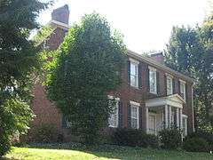
Meldahl House |
Upload image |
000000001991-05-17-0000May 17, 1991
(#91000550) |
Washington Bottom Rd. off WV 892
39°13′28″N 81°40′57″W / 39.224444°N 81.6825°W / 39.224444; -81.6825 (Meldahl House) |
Washington |
|
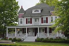
| 25 |
Dr. W. W. Monroe House |
|
000000002012-08-01-0000August 1, 2012
(#12000469) |
1703 Park Avenue
39°16′10″N 81°31′58″W / 39.269314°N 81.532685°W / 39.269314; -81.532685 (Dr. W. W. Monroe House) |
Parkersburg |
|
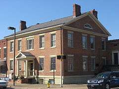
| 26 |
George Neale, Jr., House |
|
000000001980-01-10-0000January 10, 1980
(#80004045) |
331 Juliana St.
39°15′58″N 81°33′46″W / 39.266111°N 81.562778°W / 39.266111; -81.562778 (George Neale, Jr., House) |
Parkersburg |
|
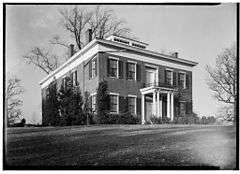
| 27 |
Oakland |
|
000000001979-05-29-0000May 29, 1979
(#79002604) |
1131 7th St.
39°15′52″N 81°32′36″W / 39.264444°N 81.543333°W / 39.264444; -81.543333 (Oakland) |
Parkersburg |
|
| 28 |
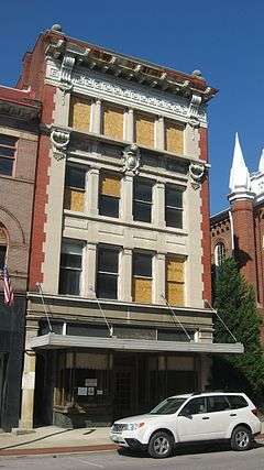
Oeldorf Building/Wetherell's Jewelers |
|
000000001982-12-10-0000December 10, 1982
(#82001781) |
809 Market St.
39°16′04″N 81°33′25″W / 39.267778°N 81.557056°W / 39.267778; -81.557056 (Oeldorf Building/Wetherell's Jewelers) |
Parkersburg |
|
| 29 |
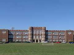
Parkersburg High School-Washington Avenue Historic District |
|
000000001992-07-16-0000July 16, 1992
(#92000895) |
Washington Ave. from Park Ave. to Dudley Ave., including 2101 Dudley
39°16′34″N 81°32′23″W / 39.276111°N 81.539722°W / 39.276111; -81.539722 (Parkersburg High School-Washington Avenue Historic District) |
Parkersburg |
|
| 30 |
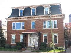
Parkersburg Women's Club |
|
000000001982-10-08-0000October 8, 1982
(#82001782) |
323 9th St.
39°16′02″N 81°33′21″W / 39.267222°N 81.555833°W / 39.267222; -81.555833 (Parkersburg Women's Club) |
Parkersburg |
|
| 31 |
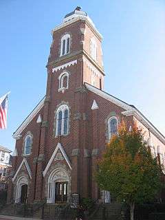
St. Francis Xavier Church |
|
000000001978-12-22-0000December 22, 1978
(#78002813) |
532 Market St.
39°15′58″N 81°33′35″W / 39.266111°N 81.559722°W / 39.266111; -81.559722 (St. Francis Xavier Church) |
Parkersburg |
|
| 32 |
Sharon Lodge No. 28 IOOF |
|
000000001982-10-08-0000October 8, 1982
(#82001784) |
316 5th St.
39°15′55″N 81°33′37″W / 39.265278°N 81.560278°W / 39.265278; -81.560278 (Sharon Lodge No. 28 IOOF) |
Parkersburg |
|
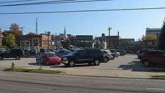
| 33 |
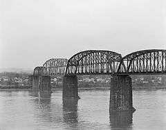
Sixth Street Railroad Bridge |
|
000000001982-12-10-0000December 10, 1982
(#82001785) |
6th Street
39°16′15″N 81°33′54″W / 39.27079°N 81.56503°W / 39.27079; -81.56503 (Sixth Street Railroad Bridge) |
Parkersburg |
Extends into Washington County, Ohio
|
| 34 |
Smith Building |
|
000000001982-12-10-0000December 10, 1982
(#82001786) |
310½ Market St.
39°15′53″N 81°33′44″W / 39.264722°N 81.562222°W / 39.264722; -81.562222 (Smith Building) |
Parkersburg |
Demolished
|
| 35 |
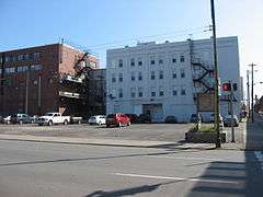
W.H. Smith Hardware Company Building |
|
000000002003-05-02-0000May 2, 2003
(#03000349) |
119 3rd St.
39°15′58″N 81°33′49″W / 39.266111°N 81.563611°W / 39.266111; -81.563611 (W.H. Smith Hardware Company Building) |
Parkersburg |
|
| 36 |
Smoot Theater |
|
000000001982-10-08-0000October 8, 1982
(#82001787) |
213 5th St.
39°15′59″N 81°33′39″W / 39.266389°N 81.560833°W / 39.266389; -81.560833 (Smoot Theater) |
Parkersburg |
|
| 37 |
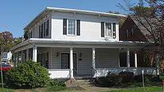
Tavenner House |
|
000000001982-11-10-0000November 10, 1982
(#82001788) |
2401 Camden Ave.
39°15′19″N 81°33′04″W / 39.255278°N 81.551111°W / 39.255278; -81.551111 (Tavenner House) |
Parkersburg |
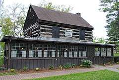
|
| 38 |
Tomlinson Mansion |
|
000000001974-07-24-0000July 24, 1974
(#74002022) |
901 W. 3rd St.
39°24′02″N 81°27′49″W / 39.400556°N 81.463611°W / 39.400556; -81.463611 (Tomlinson Mansion) |
Williamstown |
|
| 39 |
Tracewell House |
Upload image |
000000001991-04-26-0000April 26, 1991
(#91000450) |
WV 95 west of Gihon Rd.
39°14′54″N 81°35′24″W / 39.248333°N 81.59°W / 39.248333; -81.59 (Tracewell House) |
Parkersburg |
|
| 40 |
Trinity Episcopal Church Rectory |
|
000000001982-12-10-0000December 10, 1982
(#82001789) |
430 Juliana St.
39°15′59″N 81°33′41″W / 39.266500°N 81.561389°W / 39.266500; -81.561389 (Trinity Episcopal Church Rectory) |
Parkersburg |
|
| 41 |
Trinity Protestant Episcopal Church |
|
000000001982-12-10-0000December 10, 1982
(#82001790) |
424 Juliana St.
39°15′59″N 81°33′41″W / 39.266389°N 81.561389°W / 39.266389; -81.561389 (Trinity Protestant Episcopal Church) |
Parkersburg |
|
| 42 |
Union Trust & Deposit Co./Union Trust National Bank |
|
000000001982-10-08-0000October 8, 1982
(#82001791) |
700 Market St.
39°16′01″N 81°33′29″W / 39.266944°N 81.558056°W / 39.266944; -81.558056 (Union Trust & Deposit Co./Union Trust National Bank) |
Parkersburg |
|
| 43 |
Peter G. Van Winkle House |
|
000000001982-10-08-0000October 8, 1982
(#82001792) |
600 Juliana St.
39°16′02″N 81°33′35″W / 39.267222°N 81.559722°W / 39.267222; -81.559722 (Peter G. Van Winkle House) |
Parkersburg |
Demolished
|
| 44 |
Walton Wait House |
|
000000001982-12-10-0000December 10, 1982
(#82001793) |
1232 Murdoch Ave.
39°16′27″N 81°33′19″W / 39.274167°N 81.555278°W / 39.274167; -81.555278 (Walton Wait House) |
Parkersburg |
Demolished
|
| 45 |
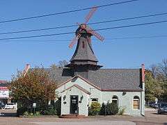
Windmill Quaker State |
|
000000001982-10-08-0000October 8, 1982
(#82001795) |
800 Murdoch Ave.
39°16′11″N 81°33′32″W / 39.269722°N 81.558889°W / 39.269722; -81.558889 (Windmill Quaker State) |
Parkersburg |
|
| 46 |
Wood County Courthouse |
|
000000001979-08-29-0000August 29, 1979
(#79002606) |
Court Sq. at 3rd and Market St.
39°15′53″N 81°33′46″W / 39.264722°N 81.562778°W / 39.264722; -81.562778 (Wood County Courthouse) |
Parkersburg |
|