| [3] |
Name on the Register |
Image |
Date listed[4] |
Location |
City or town |
Description |
|---|
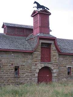
| 1 |
J. C. Adams Stone Barn |
|
000000001979-01-12-0000January 12, 1979
(#79001399) |
Northeast of Sun River off U.S. Route 89
47°32′25″N 111°41′11″W / 47.540278°N 111.686389°W / 47.540278; -111.686389 (J. C. Adams Stone Barn) |
Sun River |
|
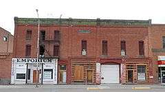
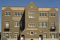
| 2 |
Arvon Block |
|
000000001991-09-26-0000September 26, 1991
(#91001446) |
114-116 1st Ave., S.
47°30′14″N 111°18′15″W / 47.503889°N 111.304167°W / 47.503889; -111.304167 (Arvon Block) |
Great Falls |
|
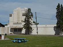
| 3 |
Belt Commercial Historic District |
Upload image |
000000002004-12-23-0000December 23, 2004
(#04001380) |
Castner St.
47°23′12″N 110°55′39″W / 47.386667°N 110.9275°W / 47.386667; -110.9275 (Belt Commercial Historic District) |
Belt |
|
| 4 |
Belt Jail |
Upload image |
000000001980-03-10-0000March 10, 1980
(#80002400) |
Castner St.
47°23′08″N 110°55′40″W / 47.385556°N 110.927778°W / 47.385556; -110.927778 (Belt Jail) |
Belt |
|
| 5 |
Burlingame School |
Upload image |
000000001992-06-01-0000June 1, 1992
(#92000575) |
Address Restricted
|
Belt |
|
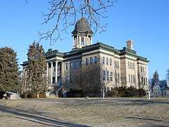
| 6 |
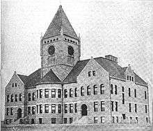
Cascade County Courthouse |
|
000000001980-04-16-0000April 16, 1980
(#80002401) |
415 2nd Ave., N.
47°30′29″N 111°17′58″W / 47.508056°N 111.299444°W / 47.508056; -111.299444 (Cascade County Courthouse) |
Great Falls |
|
| 7 |
Chicago, Milwaukee and St. Paul Passenger Depot |
|
000000001988-10-13-0000October 13, 1988
(#88001119) |
River Dr., N.
47°30′25″N 111°18′29″W / 47.506944°N 111.308056°W / 47.506944; -111.308056 (Chicago, Milwaukee and St. Paul Passenger Depot) |
Great Falls |
|
| 8 |
Timothy Edwards Collins Mansion |
|
000000001980-08-27-0000August 27, 1980
(#80002402) |
1003-1017 2nd Ave., NW.
47°30′36″N 111°19′43″W / 47.51°N 111.328611°W / 47.51; -111.328611 (Timothy Edwards Collins Mansion) |
Great Falls |
|
| 9 |
Crocker-Jarvi Homestead |
Upload image |
000000001992-06-01-0000June 1, 1992
(#92000572) |
Address Restricted
|
Belt |
|
| 10 |
East Side Neighborhood Historic District |
Upload image |
000000002016-04-19-0000April 19, 2016
(#16000185) |
Central Ave. and 1st Ave. between 15th and 16th Sts.
47°30′21″N 111°16′51″W / 47.505776°N 111.280820°W / 47.505776; -111.280820 (East Side Neighborhood Historic District) |
Great Falls |
|
| 11 |
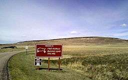
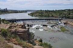
First Peoples Buffalo Jump |
|
000000002015-07-21-0000July 21, 2015
(#15000623) |
First Peoples Buffalo Jump State Park
47°28′46″N 111°31′27″W / 47.47946°N 111.52427°W / 47.47946; -111.52427 (First Peoples Buffalo Jump) |
Ulm vicinity |
Either the largest buffalo jump in North America, or the world; and maybe the most utilized.
|
| 12 |
First United Methodist Church Parsonage |
|
000000002003-12-23-0000December 23, 2003
(#03001329) |
113 6th St., N.
47°30′26″N 111°17′47″W / 47.507222°N 111.296389°W / 47.507222; -111.296389 (First United Methodist Church Parsonage) |
Great Falls |
|
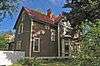
| 13 |
Lee M. Ford House |
|
000000001990-08-10-0000August 10, 1990
(#90001215) |
401 4th Ave., N.
47°30′37″N 111°18′00″W / 47.510278°N 111.3°W / 47.510278; -111.3 (Lee M. Ford House) |
Great Falls |
|
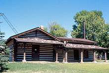
| 14 |
Fort Shaw Historic District and Cemetery |
Upload image |
000000001985-01-11-0000January 11, 1985
(#85000065) |
1 mile northwest of Fort Shaw
47°30′36″N 111°49′13″W / 47.51°N 111.820278°W / 47.51; -111.820278 (Fort Shaw Historic District and Cemetery) |
Fort Shaw |
|
| 15 |
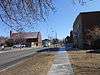
Great Falls Central Business Historic District |
|
000000002004-08-20-0000August 20, 2004
(#04000374) |
2nd Ave., N., 1st Ave., N., Central Ave., and 1st Ave., S.
47°30′21″N 111°17′54″W / 47.505833°N 111.298333°W / 47.505833; -111.298333 (Great Falls Central Business Historic District) |
Great Falls |
|
| 16 |
Great Falls Central High School |
|
000000001976-09-01-0000September 1, 1976
(#76001120) |
1400 1st Ave., N.
47°30′21″N 111°16′55″W / 47.505833°N 111.281944°W / 47.505833; -111.281944 (Great Falls Central High School) |
Great Falls |
|
| 17 |
Great Falls High School Historic District |
|
000000002013-03-20-0000March 20, 2013
(#13000097) |
1900 2nd Ave., S.
47°30′05″N 111°16′29″W / 47.501318°N 111.274721°W / 47.501318; -111.274721 (Great Falls High School Historic District) |
Great Falls |
|
| 18 |
Great Falls Northside Residential Historic District |
|
000000001991-04-01-0000April 1, 1991
(#91000355) |
200-900 blocks of 4th Ave., N., the 100-900 blocks of 3rd Ave., N., and the 500-900 blocks of 2nd Ave., N.
47°30′32″N 111°17′50″W / 47.508889°N 111.297222°W / 47.508889; -111.297222 (Great Falls Northside Residential Historic District) |
Great Falls |
|
| 19 |
Great Falls Portage |
|
000000001966-10-15-0000October 15, 1966
(#66000429) |
Southeast of Great Falls at the junction of U.S. Routes 87, 89, and 91
47°31′52″N 111°09′05″W / 47.531111°N 111.151389°W / 47.531111; -111.151389 (Great Falls Portage) |
Great Falls |
|
| 20 |
Great Falls Railroad Historic District |
|
000000001993-02-19-0000February 19, 1993
(#93000038) |
Park and River Drs., the 100-400 blocks of 2nd St., S., the 100-200 blocks of 1st and 2nd Aves., S., and the 100-300 blocks of 3rd St., S.
47°30′14″N 111°17′48″W / 47.503889°N 111.296667°W / 47.503889; -111.296667 (Great Falls Railroad Historic District) |
Great Falls |
|
| 21 |
Great Falls West Bank Historic District |
Upload image |
000000002010-08-30-0000August 30, 2010
(#10000587) |
300 and 400 blocks of 3rd St. NW
47°30′44″N 111°18′58″W / 47.512222°N 111.316111°W / 47.512222; -111.316111 (Great Falls West Bank Historic District) |
Great Falls |
|
| 22 |
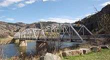
Hardy Bridge |
|
000000002010-01-04-0000January 4, 2010
(#09001180) |
Milepost 6 on Old U.S. Route 91
47°10′01″N 111°50′04″W / 47.166892°N 111.834433°W / 47.166892; -111.834433 (Hardy Bridge) |
Cascade |
|
| 23 |
Heikkila-Mattila Homestead |
Upload image |
000000001992-06-01-0000June 1, 1992
(#92000573) |
Address Restricted
|
Belt |
|
| 24 |
Kraftenberg Homestead |
Upload image |
000000001992-06-01-0000June 1, 1992
(#92000574) |
Address Restricted
|
Belt |
|
| 25 |
Lewis-Nevala Homestead |
Upload image |
000000001992-06-01-0000June 1, 1992
(#92000576) |
Address Restricted
|
Belt |
|
| 26 |
Margaret Block |
|
000000001984-08-02-0000August 2, 1984
(#84002447) |
413-415 Central Ave.
47°30′20″N 111°17′57″W / 47.505556°N 111.299167°W / 47.505556; -111.299167 (Margaret Block) |
Great Falls |
|
| 27 |
Masonic Temple |
|
000000002000-12-28-0000December 28, 2000
(#00001568) |
821 Central Ave.
47°30′26″N 111°17′32″W / 47.507222°N 111.292222°W / 47.507222; -111.292222 (Masonic Temple) |
Great Falls |
|
| 28 |
Mullan Road |
|
000000001975-03-13-0000March 13, 1975
(#75001080) |
North of Great Falls in the Benton Lake National Wildlife Refuge
47°41′49″N 111°19′10″W / 47.696944°N 111.319444°W / 47.696944; -111.319444 (Mullan Road) |
Great Falls |
Extends into Benewah and Kootenai counties in Idaho
|
| 29 |
Neihart School |
Upload image |
000000002003-03-07-0000March 7, 2003
(#03000089) |
200 S. Main St.
46°55′45″N 110°43′51″W / 46.929167°N 110.730833°W / 46.929167; -110.730833 (Neihart School) |
Neihart |
|
| 30 |
Northern Montana State Fairground Historic District |
|
000000001989-01-13-0000January 13, 1989
(#88003143) |
3rd St., NW.
47°30′40″N 111°19′03″W / 47.511111°N 111.3175°W / 47.511111; -111.3175 (Northern Montana State Fairground Historic District) |
Great Falls |
|
| 31 |
Old U.S. Highway 91 Historic District |
Upload image |
000000002013-08-27-0000August 27, 2013
(#13000624) |
Between I-15 Spring Cr. & Hardy Cr. Interchanges
Coordinates missing |
Wolf Creek vicinity |
|
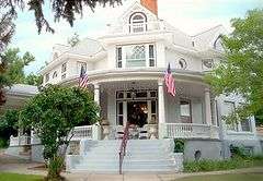
| 32 |
Harry E. Randall House |
|
000000001986-03-27-0000March 27, 1986
(#86000583) |
1003 4th Ave., N.
47°30′36″N 111°17′21″W / 47.51°N 111.289167°W / 47.51; -111.289167 (Harry E. Randall House) |
Great Falls |
|
| 33 |
Roberts Building |
|
000000001985-09-12-0000September 12, 1985
(#85002165) |
520-526 Central Ave.
47°30′18″N 111°17′49″W / 47.505°N 111.296944°W / 47.505; -111.296944 (Roberts Building) |
Great Falls |
|
| 34 |
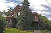
Charles M. Russell House and Studio |
|
000000001966-10-15-0000October 15, 1966
(#66000430) |
1217-1219 4th Ave., N.
47°30′36″N 111°17′05″W / 47.51°N 111.284722°W / 47.51; -111.284722 (Charles M. Russell House and Studio) |
Great Falls |
|
| 35 |
Charlie and Nancy Russell Honeymoon Cabin |
Upload image |
000000002005-12-16-0000December 16, 2005
(#05001408) |
20 Russell Dr., S.
47°16′12″N 111°41′53″W / 47.27°N 111.698056°W / 47.27; -111.698056 (Charlie and Nancy Russell Honeymoon Cabin) |
Cascade |
|
| 36 |
St. Peter's Mission Church and Cemetery |
Upload image |
000000001984-08-03-0000August 3, 1984
(#84002452) |
West of Cascade
47°18′02″N 111°55′14″W / 47.300556°N 111.920556°W / 47.300556; -111.920556 (St. Peter's Mission Church and Cemetery) |
Cascade |
|
| 37 |
Stone Homestead |
Upload image |
000000001992-06-01-0000June 1, 1992
(#92000577) |
Address Restricted
|
Belt |
|
| 38 |
Tenth Street Bridge |
|
000000001996-04-25-0000April 25, 1996
(#96000480) |
10th St. across the Missouri River
47°31′20″N 111°17′22″W / 47.522222°N 111.289444°W / 47.522222; -111.289444 (Tenth Street Bridge) |
Great Falls |
|
| 39 |
Tower Rock |
|
000000002002-03-18-0000March 18, 2002
(#02000213) |
8 miles south of Cascade at Interstate 15 interchange 247
47°11′00″N 111°48′51″W / 47.183333°N 111.814167°W / 47.183333; -111.814167 (Tower Rock) |
Cascade |
|
| 40 |
Ulm Pishkun |
|
000000001974-12-17-0000December 17, 1974
(#74001093) |
Address Restricted
|
Ulm |
|
| 41 |
Union Bethel African Methodist Episcopal Church |
|
000000002003-09-11-0000September 11, 2003
(#03000924) |
916 5th Ave., S.
47°29′58″N 111°17′25″W / 47.499444°N 111.290278°W / 47.499444; -111.290278 (Union Bethel African Methodist Episcopal Church) |
Great Falls |
|
| 42 |
Ursuline Academy |
|
000000001991-09-26-0000September 26, 1991
(#91001447) |
2300 Central Ave.
47°30′15″N 111°15′58″W / 47.504167°N 111.266111°W / 47.504167; -111.266111 (Ursuline Academy) |
Great Falls |
|
| 43 |
US Post Office and Courthouse-Great Falls |
|
000000001986-03-14-0000March 14, 1986
(#86000681) |
215 1st Ave., N.
47°30′24″N 111°18′11″W / 47.506667°N 111.303056°W / 47.506667; -111.303056 (US Post Office and Courthouse-Great Falls) |
Great Falls |
|
| 44 |
Robert Vaughn Homestead |
Upload image |
000000001982-06-14-0000June 14, 1982
(#82003160) |
Vaughn Cemetery Rd. (Cascade County Rd.)
47°32′58″N 111°33′14″W / 47.549444°N 111.553889°W / 47.549444; -111.553889 (Robert Vaughn Homestead) |
Vaughn |
|
| 45 |
O.S. Warden Bridge |
|
000000002012-03-26-0000March 26, 2012
(#12000168) |
10th Ave. S. across Missouri River
47°29′36″N 111°18′46″W / 47.4934°N 111.312768°W / 47.4934; -111.312768 (O.S. Warden Bridge) |
Great Falls |
part of the Montana's Steel Stringer and Steel Girder Bridges Multiple Property Submission
|
| 46 |
Wargelin-Warila Homestead |
Upload image |
000000001992-06-01-0000June 1, 1992
(#92000578) |
Address Restricted
|
Belt |
|

_2002-05.jpg)
_-_Cascade_County%2C_Montana.png)

_-_Cascade_County%2C_Montana.png)
_-_Cascade_County%2C_Montana.png)
.jpg)
_-_Cascade_County%2C_Montana.png)
_-_Cascade_County%2C_Montana.png)
_-_Cascade_County%2C_Montana.png)
_-_Cascade_County%2C_Montana.png)