Nandal, Iran
| Nandal ناندل | |
|---|---|
| village | |
 Nandal | |
| Coordinates: 36°01′50″N 52°10′33″E / 36.03056°N 52.17583°ECoordinates: 36°01′50″N 52°10′33″E / 36.03056°N 52.17583°E | |
| Country |
|
| Province | Mazandaran |
| County | Amol |
| Bakhsh | Larijan |
| Rural District | Larijan-e Sofla |
| Population (2006) | |
| • Total | 315 |
| Time zone | IRST (UTC+3:30) |
| • Summer (DST) | IRDT (UTC+4:30) |
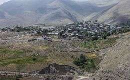
Nandal village, Amol county, Mazandaran
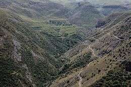
Road to Nandal village
Nandal (Persian: ناندل, also Romanized as Nāndal and Nandel; also known as Nunāl)[1] is a village in Larijan-e Sofla Rural District, Larijan District, Amol County, Mazandaran Province, Iran. At the 2006 census, its population was 315, in 90 families.[2]
References
- ↑ Nandal can be found at GEOnet Names Server, at this link, by opening the Advanced Search box, entering "-3076443" in the "Unique Feature Id" form, and clicking on "Search Database".
- ↑ "Census of the Islamic Republic of Iran, 1385 (2006)". Islamic Republic of Iran. Archived from the original (Excel) on 2011-11-11.
This article is issued from Wikipedia - version of the 5/14/2016. The text is available under the Creative Commons Attribution/Share Alike but additional terms may apply for the media files.