Myton-on-Swale
| Myton-on-Swale | |
 Myton-on-Swale |
|
 Myton-on-Swale |
|
| Population | 152 [1] |
|---|---|
| OS grid reference | SE439666 |
| Civil parish | Myton-on-Swale |
| District | Hambleton |
| Shire county | North Yorkshire |
| Region | Yorkshire and the Humber |
| Country | England |
| Sovereign state | United Kingdom |
| Post town | YORK |
| Postcode district | YO61 2 |
| Police | North Yorkshire |
| Fire | North Yorkshire |
| Ambulance | Yorkshire |
| EU Parliament | Yorkshire and the Humber |
| UK Parliament | Thirsk and Malton |
Coordinates: 54°05′38″N 1°19′44″W / 54.094°N 1.329°W
Myton-on-Swale is a village and civil parish in the Hambleton district of North Yorkshire, England. It is about 3 miles (4.8 km) east of Boroughbridge and on the River Swale.
History
The village is mentioned in the Domesday Book as Mitune in the Bulford hundred.[2] Prior to the Norman invasion, the manor was split between Ligulf, Gospatric and Alverle. After 1086, the manor was the possession of Robert de Mortain, who tenanted some of the land to Niel Fossard and some to Robert de Stutevil. Eventually part of the manor passed to the Mowbray family. In 1294 the manor was granted to St Mary's Abbey in York until its dissolution on 1539. Afterwards it was granted to Lord Burghley and John Fortescue, and eventually was sold to the Stapyltons.[3][4]
The Battle of Myton was fought opposite the village on the north bank of the Swale on 20 September 1319 between local levies, led by William Melton, Archbishop of York, and Scots raiders led by James Douglas and Thomas Randolph. The Yorkshiremen, with their backs to the river, were routed with heavy losses including many who drowned in the Swale.[3][4]
Governance
The village lies within the Thirsk and Malton Parliamentary constituency. It also lies within the Helperby ward of Hambleton District Council and the Easingwold electoral division of North Yorkshire County Council.[5]
Geography
The nearest settlements are Lower Dunsforth 1 mile (1.6 km) to the south; Tholthorpe 2.2 miles (3.5 km) to the east; Aldborough 2 miles (3.2 km) to the west and Helperby 2.1 miles (3.4 km) to the north. The village lies directly on the south bank of the River Swale close to its confluence with the River Ure.[5]
The 1881 UK Census recorded the population as 189.[3] The 2001 UK Census recorded the population as 154, of which 114 were over sixteen years old and of these, 72 were in employment. There were 62 dwellings of which 24 were detached.[6]
Religion
.jpg)
The village church is dedicated to St Mary and is a Grade II* listed building built in the 13th century, with restorations in the 15th and 19th centuries.[7] In 1820, the Stapylton family had the remains of Robert de Mowbray transferred from Byland Abbey to be interred at the church. They were returned later in the 19th century.[3][4][8]
Notable people
The Stapylton family have been in residence at Myton Hall since the 17th century. Among the many descendants the following lords of the manor of Myton are of note:[3][4]
- Sir Bryan Stapylton (1657-1727), MP for Aldborough (1679) and MP for Boroughbridge (1690-1715). Also Sheriff of Yorkshire (1683-4).
- Sir John Stapylton (1683-1733), MP for Boroughbridge (1705-8).
The village is home to Sir Ken Morrison CBE (born 20 October 1931) who was the executive chairman of Wm Morrison Supermarkets plc, the fourth largest supermarket group in the United Kingdom. Sir Ken Morrison now holds the office of President of Wm Morrison Supermarkets plc.
Notable buildings
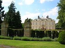

Myton Hall is a Grade I Listed Building and was the seat of the Stapylton family from around 1693, though it may be slightly earlier, until 1933. The family date back beyond the Norman Conquest, having previously held lands around Stapleton, Richmondshire.[3][4][9][10]
To the east of Myton Hall are the gate piers, wall and railings to the estate which have also been assessed as worthy of Grade I Listing.[11]
In addition to the above and the church, there are two other Grade II Listed Buildings, including the 1868 iron bridge, built by the Stapylton family and was a toll bridge that replaced the ferry and previous bridge.[3][4][12]
References
- ↑ "Parish population 2011". Neighbourhood Statistics. Office for National Statistics. Retrieved 29 July 2015.
- ↑ Myton-on-Swale in the Domesday Book. Retrieved 4 January 2013.
- 1 2 3 4 5 6 7 Bulmer's Topography, History and Directory (Private and Commercial) of North Yorkshire 1890. S&N Publishing. 1890. pp. 765, 766. ISBN 1-86150-299-0.
- 1 2 3 4 5 6 "Local History". Retrieved 4 January 2013.
- 1 2 Ordnance Survey Open Viewer
- ↑ "2001 UK Census". Neighbourhood Statistics. Office for National Statistics. Retrieved 4 January 2013.
- ↑ Historic England. "CHURCH OF ST MARY (1294251)". National Heritage List for England. Retrieved 9 December 2013.
- ↑ "Church Listing". Retrieved 4 January 2013.
- ↑ "Myton Hall History". Retrieved 4 January 2013.
- ↑ "Hall Listing". Retrieved 4 January 2013.
- ↑ "Gates Listing". Retrieved 4 January 2013.
- ↑ "Bridge Listing". Retrieved 4 January 2013.
External links
![]() Media related to Myton-on-Swale at Wikimedia Commons
Media related to Myton-on-Swale at Wikimedia Commons