Musuan Peak
| Musuan Peak | |
|---|---|
| Mount Calayo | |
 | |
| Highest point | |
| Elevation | 646 m (2,119 ft) [1] |
| Listing | Active volcano |
| Coordinates | 7°52′36″N 125°4′6″E / 7.87667°N 125.06833°ECoordinates: 7°52′36″N 125°4′6″E / 7.87667°N 125.06833°E [1] |
| Geography | |
.svg.png) Musuan Peak Location within the Philippines | |
| Location | Mindanao |
| Country | Philippines |
| Region | Northern Mindanao |
| Province | Bukidnon |
| Municipality | Maramag |
| Geology | |
| Mountain type | Lava dome |
| Last eruption | 1886 or 1887 |
| Climbing | |
| Easiest route | Hike |
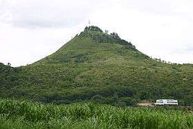
Musuan Peak or Mount Musuan /ˈmʊswən/, also known as Mount Calayo (/kəˈlɑːjoʊ/, literally "Fire Mountain") is an active volcano on the island of Mindanao in the Philippines. It is 4.5 kilometres (2.8 mi) south of the city of Valencia, province of Bukidnon, and 81 kilometres (50 mi) southeast of Cagayan de Oro City.
Physical characteristics

Musuan is a lava dome and tuff cone.
It has an elevation of 646 metres (2,119 ft) asl, and a base diameter of 3 kilometres (1.9 mi).
Eruptions
The Philippine Institute of Volcanology and Seismology reports that Musuan erupted in 1866 and 1867, but the Smithsonian Institution's Global Volcanism Program records another eruption, possibly phreatic, that "burned everything around it." The explosion supposedly occurred four years before the 1891 visit of a Jesuit priest, who reported that he could not examine the volcano more closely because of strong solfataric activity.[1]
A strong seismic swarm occurred near Musuan in 1976, and again around mid-2011.[1]
Musuan is one of the active volcanoes in the Philippines, which are all part of the Pacific ring of fire.
Flora
Mount Musuan's northern slope is still covered by a primary rainforest. The rest is covered predominantly by Cogon grass (Imperata cylindrica). Reforestation efforts on the bare areas, both in tree-planting drives and by Central Mindanao University personnel, have established temporary forests of Acacia mangium and conifers.
There are 524 species of plants in Mt. Musuan under 353 genera and 135 families. 301 species are trees, 51 shrubs, 50 grasses and sedges, 46 herbs, 42 vines, 31 ferns, and 3 fern allies. 188 species (35%) are economically important, 128 species (24%) are endemic, and 3 (1%) are endangered species. Musuan peak has approximately 6,354 individual trees. The most common tree species (in density and frequency) are the Mallotus multiglandulosus (Kamala tree) and Colona serratifolia, followed by Clausena brevistyla and Alstonia scholaris (Blackboard tree).[2] Three species of pteridophytes are locally threatened: Marsilea crenata ("apat-apat"), Ceratopteris thalictroides ("pakung-sungay"), and Lycopodiella cernua (clubmoss). 10 species of pteridophytes are endemic to the area.[3]
History and Infrastructure
Mt. Musuan's lack of any visible crater has led to some local skepticism of it being an active volcano.[4] Still, the imagery evoked by its name variant 'Mount Calayo' (Fire Mountain) and the stories told by local Bukidnon tribesmen keeps people wary of the relatively small mountain which doesn't look like a volcano at all.[5]
Valencia City is located North of the peak, the Central Mindanao University (CMU) and Barangay Dologon at the southwest, and the Pulangi River on the entire eastern side.[6]
At the foot of Musuan Peak is the Mt. Musuan Zoological and Botanical Garden of the Central Mindanao University. It includes a butterfly greenhouse and a reforestation nursery among its buildings. The Sayre Highway and a research center of the Philippine Carabao Center are located on the western slopes.[7] It has a tourist shop which sells dairy products made from Carabao milk. South of the mountain are the university agricultural facilities including a cattle ranch, a poultry farm, greenhouses, and a dairy.

Due to its proximity to the university and the university town proper, it has become a popular destination for students, teachers, and tourists; either for picnics or a study of the flora and fauna of one of the few remnants of the jungles that once covered the valleys of the surrounding areas.[8] From its isolated position in the middle of the valley and the very small surface area of its highest point (only a few meters), the entire countryside is visible from the top. Currently its slopes has been the target of extensive reforestation efforts partly paid for by the establishment of toll gates to hikers intending to go up the mountain.
See also
- List of active volcanoes in the Philippines
- List of potentially active volcanoes in the Philippines
- List of inactive volcanoes in the Philippines
- Philippine Institute of Volcanology and Seismology
- Volcano
- Central Mindanao University
- Pulangi River
References
- 1 2 3 4 "Musuan". Global Volcanism Program. Smithsonian Institution. Retrieved December 5, 2009.
- ↑ Assessment of plant diversity in Mt. Musuan, Bukidnon. by Victor B. Amoroso, Florfe M. Acma, and Jonna A. Timada, CMU Journal of Science
- ↑ Pteridophyte and Gymnosperm Diversity in Musuan, Bukidnon. Victor B. Amoroso, Philippine Journal of Systematic Biology, June 2007; Accessed December 2010
- ↑ Musuan Peak, Bukidnon
- ↑ Calayo Volcano, Philippines
- ↑ Wikimapia: Musuan Peak
- ↑ Philippine Carabao Center at Central Mindanao University, Musuan, Bukidnon
- ↑ Maramag Things to Do Tips