Mustamäe
| Mustamäe | |||
|---|---|---|---|
| District of Tallinn | |||
|
Sõpruse puiestee | |||
| |||
 Location of Mustamäe in Tallinn. | |||
| Coordinates: 59°24′17″N 24°40′50″E / 59.40472°N 24.68056°ECoordinates: 59°24′17″N 24°40′50″E / 59.40472°N 24.68056°E | |||
| Country | Estonia | ||
| County | Harju County | ||
| City | Tallinn | ||
| Government | |||
| • District Elder | Helle Kalda (Centre Party) | ||
| Area | |||
| • Total | 8.1 km2 (3.1 sq mi) | ||
| Population (01.11.2014[1]) | |||
| • Total | 66,305 | ||
| • Density | 8,200/km2 (21,000/sq mi) | ||
| Website | mustamae-district | ||
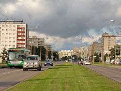

Mustamäe (Estonian for Black Hill) is one of the 8 administrative districts (Estonian: linnaosa) of Tallinn, the capital of Estonia. The smallest by area (it covers only 8.1 km²), it is at the same time the second largest district by population with 66,305 inhabitants (As of 1 November 2014).[1] It is located 5 km from the centre of Tallinn and is bordered by districts Haabersti, Nõmme, and Kristiine. Local housing is mostly represented by 5–9 storeys high panel blocks of flats, built in the 1960–1970s. Mustamäe is usually referred to as a bedroom community.
Geography
Mustamäe covers 8.1 km² and is located 5 km from the centre of Tallinn. Mustamäe is bordered by the streets Tuuliku, Kadaka tee, Tildri, Siili, Nõmme tee, Retke tee, Ehitajate tee, Üliõpilaste tee, Raja, Soone, Lossi, Mäepealse, Kadaka puiestee, Järveotsa tee. Mustamäe is bordered by Nõmme hill (part of the Baltic Klint) in the south and Tallinn Zoo in northwest.
Mustamäe is divided into 4 subdistricts (Estonian: asum):
History
Established in 1962 and completed in 1973 as a microdistrict, Mustamäe was Tallinn's first large district. Similar districts, Õismäe and Lasnamäe were completed later.
Population
| Ethnic group | Percentage |
|---|---|
| Estonians | 57.5% |
| Russians | 34.3% |
| Ukrainians | 3.2% |
| Belarusians | 1.7% |
| Finns | 0.7% |
| Jews | 0.4% |
| Tatars | 0.3% |
| Others | 1.8% |
Mustamäe has a population of 66,305 (As of 1 November 2014).[1]
| Year | 2004 | 2005 | 2006 | 2007 | 2008 | 2009 | 2010 | 2011 | 2012 | 2013 | 2014 |
|---|---|---|---|---|---|---|---|---|---|---|---|
| Population | 64,918 | 65,837 | 65,692 | 64,500 | 64,243 | 64,339 | 64,113 | 64,597 | 64,237 | 64,425 | 65,866 |
Landmarks and institutions


- Tallinn Bus Company
- Tallinn University of Technology
- Estonian Information Technology College
- Mustamäe Regional Hospital
- National Institute of Chemical Physics and Biophysics
- "Tehnopol" Technology Park including the headquarters of Skype
- Center of culture "Kaja"
- Conference center "Sütiste maja"
- Mustamäe Boiler Plant with a 125-m chimney
- Männi Park
- Shopping centre "Mustamäe Kaubanduskeskus"
- Shopping center "Magistral"
- Marketplace "Szolnoki turg" (named after the bus stop "Szolnok", which in turn is named after the town Szolnok in Hungary)
- Headquarters of Eesti Energia
- Tiit Soku Korvpallikool (Tiit Sokk Basketball School)
- Nightclub "Aspirin"
- Sculpture "Mõtlik mees" (Thoughtful man) by Tauno Kangro
Schools

- Tallinna 32. Keskkool
- Tallinna 37. Keskkool
- Tallinna 53. Keskkool
- Tallinna 63. Põhikool
- Tallinna Arte Gümnaasium (former School No. 49)
- Eurogümnaasium
- Tallinna Mustamäe Gümnaasium (former School No. 44)
- Tallinna Mustamäe Humanitaargümnaasium (former School No. 52)
- Tallinna Mustamäe Reaalgümnaasium (former School No. 51)
- Tallinna Saksa Gümnaasium (former School No. 54)
- Tallinna Tehnikagümnaasium (former School No. 43)
Transportation

Mustamäe is connected to the rest of Tallinn via three main streets: Mustamäe tee and Sõpruse puiestee lead to the centre of Tallinn, and Ehitajate tee crosses Mustamäe while connecting Nõmme and Õismäe. Other major streets include: A. H. Tammsaare tee, Kadaka tee, Ed. Vilde tee, and Akadeemia tee. Most of the public transportation operates on these streets. Mustamäe is serviced by buses and trolleybuses. Out the 8 trolleybus lines of Tallinn, 6 operate (partly) in Mustamäe.
Government
List of District Elders (linnaosavanem) of Mustamäe:[3]
| Years | Name | Party |
|---|---|---|
| 1993 | Ain Lillepalu | |
| 1993–1999 | Jevgeni Tomberg | United People's Party |
| 1999 | Vladimir Ivanov | United People's Party |
| 1999–2000 | Pavel Starostin | United People's Party |
| 2000–2001 | Voldemar Trumm | United People's Party |
| 2001–2004 | Helle Kalda | Centre Party |
| 2004 | Aivar Riisalu | Centre Party |
| 2004–2005 | Mario Sootna | People's Union |
| 2005–2009 | Kalle Mihkels | Centre Party |
| 2009–2011 | Lauri Laats | Social Democrats |
| 2011–present | Helle Kalda | Centre Party |
Cultural significance
Books:
- "The Autumn Ball: Scenes of City Life" (1979) by Mati Unt (translated from Estonian by Mart Aru)
- "Mustamäe armastus" (1978) by Arvo Valton
- "Minu Mustamäe" (2013) by Armin Kõomägi
Songs:
- "Mustamäe valss" (Mustamäe Walz), composed by Avo Tamme; lyrics by Heldur Karmo
- "Kus on mu kodu"' (Where is my home?), by Agent M
References
- 1 2 3 "Tallinna elanike arv" (in Estonian). Tallinn City Government. Retrieved 27 November 2014.
- ↑ "Tallinn arvudes 2013" (in Estonian). Tallinn. p. 19. Retrieved 10 September 2013.
- ↑ Tallinn : entsüklopeedia. 1., A-M, 2004. lk. 352
External links
| Wikimedia Commons has media related to Mustamäe. |
- Official website
- Mustamäe linnaosa üldplaneering
- Mustamäe Metamorphoses by Piret Viires
- Models of Mustamäe buildings in Google 3D Warehouse
Administrative districts (linnaosad) and subdistricts (asumid) of Tallinn | ||
|---|---|---|
| Haabersti |  | |
| Kesklinn | ||
| Kristiine | ||
| Lasnamäe | ||
| Mustamäe | ||
| Nõmme | ||
| Pirita | ||
| Põhja-Tallinn | ||