Museo Regional del Sureste de Petén

The Museo Regional del Sureste de Petén ("Southeastern Petén Regional Museum") is an archaeological museum in the town of Dolores in the Petén Department of Guatemala.[1] The museum is located 82 kilometres (51 mi) from Flores, the departmental capital, among the Maya Mountains in an area rich in archaeological sites.[2] It is open daily from 8am to 5pm.[1]
The museum is operated by the Atlas Arqueológico de Guatemala ("Archaeological Atlas of Guatemala"), a part of the Dirección General del Patrimonio Cultural y Natural ("Department of Cultural and Natural Heritage"), under the Ministerio de Cultura y Deportes ("Ministry of Culture and Sports").[3] The collection consists of artefacts belonging to the ancient Maya civilization.[4]
Development

Construction of the museum was first proposed by the Dirección General de Caminos ("Highways Department") in 1998 as part of its plans to build a highway from San Luis to Flores in order to offset any damage to Guatemala's cultural heritage caused by the construction project.[5] The land upon which the museum was built was donated in 1998,[6] and had originally been used for the first seat of the municipal council.[2] Construction began in December 1999,[7] with the fabric of the building being completed in November 2000.[7] In 2001, the Dirección General de Caminos officially handed the building over to the Ministerio de Cultura y Deportes.[2]
In 2000, the Atlas Arqueológico de Guatemala petitioned the Agencia Española de Cooperación International ("Spanish Agency for International Cooperation") for funding to restore excavated artefacts ready for display in the museum.[2] The agency responded positively and the Atlas Arqueológica was able to contract archaeologists from the Tikal National Park to carry out the restoration work.[2] This restoration process lasted two years.[2] The museum was officially opened on 17 March 2005 and is administered by staff of the Atlas Arqueológico de Guatemala.[8]
Facilities
The building consists of the exhibition halls, administrative facilities, a warehouse, guardroom, sanitary services and a community hall.[3]
Collection
The museum is dedicated to the display of objects excavated by the Atlas Arqueológico de Guatemala within the southeastern Petén region.[7] It displays approximately 125 ceramic pieces and eight stone sculptures.[8] The display of artefacts is divided into periods, ranging from the Late Preclassic through to the Postclassic,[9] covering a span from 900 BC through to 1524 AD.[9] The collection is not limited to the municipality of Dolores, it also includes pieces from the municipalities of La Libertad, Melchor de Mencos, Poptún, San Luis, Santa Ana and San Francisco.[9] Twenty-two archaeological sites are represented at the museum, they include Calzada Mopan, Copoja, Curucuitz, El Chal, El Ocote, El Reinado, Itzimte, Ix Ak, Ixcoxol, Ix Ek', Ixkun, Ixtonton, Ixtutz, La Gloria-Sacul, Limones, Machaquila, Maringa, Pueblito, Sacul, Suk Che', Ucanal and Yaltutu.[9] There are also pieces recovered from the caves of Aktun Ak'ab, Balam Na and El Chapayal.[9]
 |
| Maya civilization |
|---|
| History |
| Preclassic Maya |
| Classic Maya collapse |
| Spanish conquest of the Maya |
 Stela 2 from Ixtonton
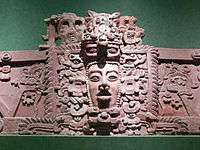
 Fragments of Panel 2 from Ixtutz
 Sculpture from Pueblito
 Late Classic vase from Ixtutz
Bowl from Suk Che'

This artefact (catalogue number PSPA-507) is a flat based ceramic bowl of the Saxche variety of the Saxche Naranja Polychrome type, belonging to the Palmar-Danta ceramic group.[10] It was excavated from Group 9 at Suk Che' and was associated with a burial.[10] The bowl has been dated to the Late Classic Period.[10]
Vase from Curucuitz

This item (catalogue number PSPA-625) is a ceramic vase excavated from the ruins of Curucuitz.[11] It was found buried in the North Structure of Group 24, where it was associated with a burial.[11] the vase has been dated to the Late Classic and is of the Paixban variety of the Paixban Ante Polychrome ceramic type, belonging to the Zacatal-Joyac ceramic group.[11]
Vase from Sacul
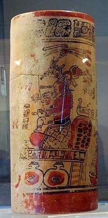
This ceramic vase (catalogue number PSPA-708) was excavated from the ruins of Sacul.[12] The piece is of the Palmar variety of the Palmar-Naranja Polychrome type, belonging to the Palmar-Danta ceramic group.[13] It has been dated to the Late Classic Period.[13] It was a funerary offering accompanying Burial 193 at Sacul, it was interred in front of Structure 1 of Group 26 of that city.[14]
The vase was a drinking vessel for chocolate and depicts a mythological scene featuring the young Moon goddess, who carries a rabbit in her arms.[15] The goddess is seated upon a throne, which is decorated with a celestial band.[15] Below her are three jars of pulque.[15] Only about half of the original scene has survived, and the text next to the goddess is illegible.[15] Only slight traces remain of a second person seated upon the same throne, to the left of the Moon goddess.[15] Two rows of supernatural beings are seated on the floor before the throne, indicating that they are visiting the enthroned principal figures.[16] Three of these visitors can be identified, including two versions of God N, represented as separate individuals, and a being that is a man-bird hybrid.[16] These figures are also accompanied by hieroglyphs, although they are also illegible.[16] The vase includes a dedicatory hieroglyphic text around the rim that identifies it as the drinking vessel of a lord of the city of Naranjo.[16]
The vase appears to represent a scene from Maya mythology in which the rabbit steals a magic hat, clothing and tribute from God L (Itsamaat). God L visits the palace of his grandson K'inich Ahau, the Sun god, who informs him that the rabbit is with the Moon goddess.[16]
Notes
- 1 2 REDCAMUS.
- 1 2 3 4 5 6 Corzo 2007, p.80.
- 1 2 Corzo 2007, p.82.
- ↑ TURISURP.
- ↑ Corzo 2007, p.79.
- ↑ Corzo 2001, p.218.
- 1 2 3 Sierra García 2008, p.55.
- 1 2 Corzo 2005, p.724.
- 1 2 3 4 5 Corzo 2007, p.89.
- 1 2 3 Corzo 2005, p.756.
- 1 2 3 Corzo 2005, p.757.
- ↑ Corzo 2005, p.758. Laporte & Mejía 2006, p.215.
- 1 2 Corzo 2005, p.758.
- ↑ Laporte & Mejía 2006, p.192.
- 1 2 3 4 5 Laporte & Mejía 2006, p.215.
- 1 2 3 4 5 Laporte & Mejía 2006, p.216.
References
| Wikimedia Commons has media related to Museo Regional del Sureste de Petén. |
- Corzo, Lilian A. (2001). "El Museo Regional del Sureste de Petén: Propuesta y desarrollo inicial." (PDF). Reporte 15, Atlas Arqueológico de Guatemala (in Spanish). Guatemala City, Guatemala: Instituto de Antropología e Historia. pp. 221–229. Archived from the original (PDF) on 2014-11-12. Retrieved 2011-02-02.
- Corzo, Lilian A. (2005). "Museo Regional del Sureste de Petén: Catálogo del material en exhibición." (PDF). Reporte 19, Atlas Arqueológico de Guatemala (in Spanish). Guatemala City, Guatemala: Instituto de Antropología e Historia. pp. 724–796. Archived from the original (PDF) on 2014-11-12. Retrieved 2011-02-02.
- Corzo, Lilian A. (2007). "El Museo Regional del Sureste de Petén, Dolores, Petén." (PDF). XX Simposio de Investigaciones Arqueológicas en Guatemala, 2006 (edited by J.P. Laporte, B. Arroyo and H. Mejía) (in Spanish). Guatemala City, Guatemala: Museo Nacional de Arqueología y Etnología. pp. 77–106. Retrieved 2011-02-02.
- Laporte, Juan Pedro; Héctor E. Mejía (2006). "Grupos residenciales explorados en el área central y periférica de Sacul" (PDF). Sacul, Petén, Guatemala: Exploraciones en una entidad política de las Montañas Mayas, 1985-2006 (edited by J.P. Laporte y H. Mejía) (in Spanish). Guatemala: Atlas Arqueológico de Guatemala, Dirección General del Patrimonio Cultural y Natural, Ministerio de Cultura y Deportes. pp. 147–219. Archived from the original (PDF) on 2014-11-12. Retrieved 2011-02-04.
- REDCAMUS. "Museo Regional del Sureste de Petén" (in Spanish). Red Centroamericana de Museos (REDCAMUS). Archived from the original on 2014-11-02. Retrieved 2011-02-02.
- Sierra García, Julio Alexander (2008). "Diagnóstico Socioeconómico, Potencialidades Productivas y Propuestas de Inversión: Comercialización (Hotelería) y Proyecto: Producción de Maní, Municipio de Dolores, Departamento de Petén" (PDF) (in Spanish). Guatemala: Facultad de Ciencias Económicas, Universidad de San Carlos de Guatemala. Archived from the original (PDF) on 2012-03-16. Retrieved 2011-02-03.
- TURISURP. "Ruta Naj Tunich: Atractivos" (in Spanish). Poptún, Guatemala: TURISURP. Archived from the original on 2012-05-26. Retrieved 2011-02-03.
Coordinates: 16°30′56.66″N 89°24′53.74″W / 16.5157389°N 89.4149278°W