Murderkill River
| Murderkill River | |
| River | |
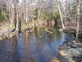 The Murderkill River downstream of Killens Pond in 2006 | |
| Country | United States |
|---|---|
| State | Delaware |
| Source | |
| - location | near Felton |
| - coordinates | 39°01′03″N 75°35′31″W / 39.01750°N 75.59194°W [1] |
| Mouth | Delaware Bay |
| - location | Bowers |
| - elevation | 3 ft (1 m) [1] |
| - coordinates | 39°03′30″N 75°23′48″W / 39.05833°N 75.39667°WCoordinates: 39°03′30″N 75°23′48″W / 39.05833°N 75.39667°W [1] |
| Length | 22 mi (35 km) [2] |
| Basin | 106 sq mi (275 km2) [3] |
 Location of the mouth of the Murderkill River | |
The Murderkill River is a river flowing to Delaware Bay in central Delaware in the United States. It is approximately 21.7 miles (34.9 km) long[2] and drains an area of 106 square miles (270 km2) on the Atlantic Coastal Plain.
The Murderkill flows for its entire length in southern Kent County. It rises just west of Felton and flows generally east-northeastwardly, through Killen Pond[4] (site of Killens Pond State Park[5]) and Coursey Pond,[6] under Carpenters Bridge, and past Frederica to Bowers, where it enters Delaware Bay about 0.5 miles (1 km) south of the mouth of the St. Jones River.[7] The Murderkill River is tidally influenced from its mouth upstream to just past Frederica,[3] and is considered by the U.S. Army Corps of Engineers to be navigable for the lower 10 miles (16 km) of its course.[8]
According to 2002 data from the United States Environmental Protection Agency, 55% of the area of the Murderkill River's watershed is occupied by agricultural uses; 17% is forested; 14% is urban; 9% is wetland; and 2% is water.[3]
The river has suffered a persistent pollution from eutrophication and organic waste in agricultural runoff. Its estuary is considered to have abnormally low rates of dissolved oxygen.
Origin of name
One description of the river's naming was recorded in 1945 by George R. Stewart, but is now considered to be an apocryphal folk tale:[9]
...remembering how they had been served at the Whore-Kill, they went some ten or twelve miles higher, where they landed again and traded with the Indians, trusting the Indians to come onto their stores ashore, and likewise aboard their sloop drinking and debauching with the Indians until they were at last barbarously murdered, and so that place was christened with their blood and to this day is called the Murderer-Kill, that is, Murderers Creek.[10]— George R. Stewart, Names on the Land: A Historical Account of Place-Naming in the United States
Dick Carter, Chair of the Delaware Heritage Commission, states that the name of Murderkill River is taken from the original Dutch for Mother River. Mother is moeder in Middle Dutch, and river is Kille. Later, under British rule, the word "River" was added to the waterway's name, effectively making it "mother river river."[9] The term "kill" is used in areas of Dutch influence in the Delaware and Hudson Valleys and other areas of the former New Netherland colony of Dutch America to describe a strait, river, or arm of the sea such as Schuylkill River in Pennsylvania.
Variant names
According to the Geographic Names Information System, the Murderkill River has also been known historically as:[1]
- Mordare Kijhlen
- Mother Creek
- Mother Kill
- Motherkill
- Motherkiln Creek
- Mothers Creek
- Murder Kill Creek
- Murther Creek
- Murtherkill
See also
References
- 1 2 3 4 Geographic Names Information System. "GNIS entry for Murderkill River (Feature ID #214364)". Retrieved 2007-01-30.
- 1 2 U.S. Geological Survey. National Hydrography Dataset high-resolution flowline data. The National Map, accessed April 1, 2011
- 1 2 3 United States Environmental Protection Agency (2005). "Decision Rationale: Total Maximum Daily Load Analysis for the Murderkill River Watershed". pp. 3–4. Retrieved 2007-01-30.
- ↑ Geographic Names Information System. "GNIS entry for Killen Pond (Feature ID #217871)". Retrieved 2007-01-30.
- ↑ "Killens Pond State Park website". Retrieved 2007-01-30.
- ↑ Geographic Names Information System. "GNIS entry for Coursey Pond (Feature ID #213834)". Retrieved 2007-01-30.
- ↑ DeLorme (2004). Maryland Delaware Atlas & Gazetteer. p.52. Yarmouth, Maine: DeLorme. ISBN 0-89933-279-X.
- ↑ U.S. Army Corps of Engineers, Philadelphia District. "Navigable waterways of the Philadelphia District.". Retrieved 2007-01-30.
- 1 2 Brown, Robin. "The Murderkill River doesn't have a grisly past". Delaware Backstory. Delaware Online. Retrieved 9/3/2015. Check date values in:
|access-date=(help) - ↑ "Names on the Land: A Historical Account of Place-Naming in the United States" Stewart, George R. 1945 pg 71
Dover (capital) | ||
| Topics |
|  |
| Society |
| |
| Cities | ||
| Towns |
| |
| Counties | ||