Mule Barn, Oklahoma
| Mule Barn, Oklahoma | |
|---|---|
| Unincorporated community | |
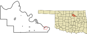 Location of Mule Barn, Oklahoma | |
| Coordinates: 36°13′2″N 96°18′42″W / 36.21722°N 96.31167°WCoordinates: 36°13′2″N 96°18′42″W / 36.21722°N 96.31167°W | |
| Country | United States |
| State | Oklahoma |
| County | Pawnee |
| Area | |
| • Total | 0.0 sq mi (0.1 km2) |
| • Land | 0.0 sq mi (0.1 km2) |
| • Water | 0.0 sq mi (0.0 km2) |
| Elevation | 837 ft (255 m) |
| Population (2000) | |
| • Total | 0 |
| • Density | 0.0/sq mi (0.0/km2) |
| Time zone | Central (CST) (UTC-6) |
| • Summer (DST) | CDT (UTC-5) |
| FIPS code | 40-49860[1] |
| GNIS feature ID | 1102947[2] |
Mule Barn was a town in Pawnee County, Oklahoma, United States. Its population was zero on both the 1990 and 2000 censuses.
According to the United States Census Bureau, the town has a total area of 0.0 square miles (0 km2), all land. The town is located at 36.21737 N, 96.31142 W.
Oklahoma law provides for the dissolution of towns under certain circumstances, including the lack of recent elections.[3] However, the Census Bureau reported no changes to the municipal status of Mule Barn between 2000 and 2006.[4] The town did get dissolved in 2008.[5]
References
- ↑ "American FactFinder". United States Census Bureau. Retrieved 2008-01-31.
- ↑ "US Board on Geographic Names". United States Geological Survey. 2007-10-25. Retrieved 2008-01-31.
- ↑ Oklahoma Statutes, §11-7-105. Accessed 2008-04-27.
- ↑ Population Estimates Geographic Change Notes: Oklahoma, United States Census Bureau, 2006. Accessed 2008-04-27.
- ↑ "Boundary Changes".
Municipalities and communities of Pawnee County, Oklahoma, United States | ||
|---|---|---|
| Cities | 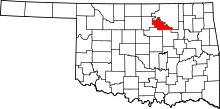 | |
| Towns | ||
| Unincorporated communities |
| |
| Footnotes | ‡This populated place also has portions in an adjacent county or counties | |
This article is issued from Wikipedia - version of the 11/13/2016. The text is available under the Creative Commons Attribution/Share Alike but additional terms may apply for the media files.