Mount Owen (Tasmania)
| Mount Owen | |
|---|---|
|
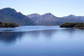
East Mount Owen wall and Lake Burbury from Bradhsaws Bridge | |
| Highest point | |
| Elevation | 1,146 m (3,760 ft) [1] |
| Prominence | 774 m (2,539 ft) [1] |
| Isolation | 8.53 km (5.30 mi) [1] |
| Coordinates | 42°05′24″S 145°36′00″E / 42.09000°S 145.60000°ECoordinates: 42°05′24″S 145°36′00″E / 42.09000°S 145.60000°E [2] |
| Geography | |
 Mount Owen Location in Tasmania | |
| Location | West Coast, Tasmania, Australia |
| Parent range | West Coast Range |
| Climbing | |
| Easiest route | from North West along track to TV tower |
Mount Owen is a mountain directly east of the town of Queenstown on the West Coast Range in Western Tasmania, Australia.
With an elevation of 1,146 metres (3,760 ft) above sea level,[1] like most of the mountains in the West Coast Range, it was named by the geologist Charles Gould after Richard Owen. The taller mountains were named after opponents or critics of Charles Darwin, the smaller after his supporters. The north western slopes are clearly seen from Gormanston and the Linda Valley 'Long Spur'.[3]
Features and access

Historically, the tree line on Mount Owen was to a high level. However, timber on the slopes was used by the local mining operations. In the early days of settlement, fires started on the slopes destroyed housing in Queenstown [4] and threatened the North Mount Lyell Railway.[5]
By the early twentieth century, the slopes of Mount Owen were denuded and had limited remnant vegetation.[6][7]
A map in Geoffrey Blainey's The Peaks of Lyell, sourced from 1900–1910, calls the north west peak the 'North Spur'. The northern slopes, clearly visible from the Lyell Highway passing through the Linda Valley, show the extent of degradation due to fire, smelter fumes and heavy rainfall. It has small glacial lakes on its upper eastern slope, indicating the extent of glaciation in the King River valley. The western slopes loom over Queenstown and in winter are regularly covered in snow. The eastern wall to its north eastern peak hangs over the western shore of Lake Burbury and, in earlier times, the North Mount Lyell Railway which passed beneath.
There are TV and communications towers on its north west peak (North Spur), which has been used a vehicle access track. Other geological features near Mount Owen include Mount Lyell to the north and Mount Huxley to the south.
See also
References
- 1 2 3 4 "Mount Owen, Australia". Peakbagger.com. Retrieved 16 June 2015.
- ↑ "Mount Owen (TAS)". Gazetteer of Australia online. Geoscience Australia, Australian Government.
- ↑ Baillie, Peter (2010). "The West Coast Range, Tasmania: Mountains and Geological Giants" (PDF). Papers and Proceedings of the Royal Society of Tasmania (reprint ed.). Hobart, Tasmania: University of Tasmania. 144: 1–13. ISSN 0080-4703. Retrieved 18 June 2015.
- ↑ "BUSH FIRES IN TASMANIA.". The Brisbane Courier. National Library of Australia. 27 December 1899. p. 5. Retrieved 5 June 2012.
- ↑ "FIRES IN TASMANIA..". The Advertiser. Adelaide: National Library of Australia. 9 October 1914. p. 11. Retrieved 5 June 2012.
- ↑ "LYELL DISTRICT DESCRIBED.". Zeehan and Dundas Herald. Hobart, Tas.: National Library of Australia. 12 September 1917. p. 1. Retrieved 5 June 2012.
- ↑ "FLORA AND FAUNA.". The Mercury. Hobart, Tas.: National Library of Australia. 22 July 1933. p. 3. Retrieved 5 June 2012.
Further reading
- Blainey, Geoffrey (2000). The Peaks of Lyell (6th ed.). Hobart: St. David's Park Publishing. ISBN 0-7246-2265-9.
- Whitham, Charles (2003). Western Tasmania – A land of riches and beauty (Reprint 2003 ed.). Queenstown: Municipality of Queenstown.