Mosses, Alabama
| Mosses, Alabama | |
|---|---|
| Town | |
|
The Ala Williams Store in Mosses. | |
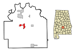 Location in Lowndes County and the state of Alabama | |
| Coordinates: 32°10′23″N 86°40′38″W / 32.17306°N 86.67722°W | |
| Country | United States |
| State | Alabama |
| County | Lowndes |
| Area | |
| • Total | 4.8 sq mi (12.4 km2) |
| • Land | 4.8 sq mi (12.4 km2) |
| • Water | 0 sq mi (0 km2) |
| Elevation | 207 ft (63 m) |
| Population (2010) | |
| • Total | 1,029 |
| • Density | 229.4/sq mi (88.8/km2) |
| Time zone | Central (CST) (UTC-6) |
| • Summer (DST) | CDT (UTC-5) |
| FIPS code | 01-51520 |
| GNIS feature ID | 0136404 |
.JPG)
Mosses is a town in Lowndes County, Alabama, United States. At the 2010 census the population was 1,029, down from 1,101 in 2000. It is part of the Montgomery Metropolitan Statistical Area. It incorporated in 1979.[1]
Geography
Mosses is located at 32°10′23″N 86°40′38″W / 32.17306°N 86.67722°W (32.173120, -86.677296).[2]
According to the U.S. Census Bureau, the town has a total area of 4.8 square miles (12 km2), all land.
Demographics
| Historical population | |||
|---|---|---|---|
| Census | Pop. | %± | |
| 1970 | 158 | — | |
| 1980 | 649 | 310.8% | |
| 1990 | 1,072 | 65.2% | |
| 2000 | 1,101 | 2.7% | |
| 2010 | 1,029 | −6.5% | |
| Est. 2015 | 955 | [3] | −7.2% |
| U.S. Decennial Census[4] 2013 Estimate[5] | |||
As of the census[6] of 2000, there were 1,101 people, 364 households, and 281 families residing in the town. The population density was 230.1 people per square mile (88.9/km²). There were 421 housing units at an average density of 88.0 per square mile (34.0/km²). The racial makeup of the town was 97.82% Black or African American, 1.18% White, 0.09% Native American, 0.09% Asian, and 0.82% from two or more races. 0.45% of the population were Hispanic or Latino of any race.
There were 364 households out of which 44.8% had children under the age of 18 living with them, 25.5% were married couples living together, 45.6% had a female householder with no husband present, and 22.8% were non-families. 20.6% of all households were made up of individuals and 3.6% had someone living alone who was 65 years of age or older. The average household size was 3.02 and the average family size was 3.50.
In the town the population was spread out with 34.6% under the age of 18, 12.9% from 18 to 24, 27.2% from 25 to 44, 17.2% from 45 to 64, and 8.2% who were 65 years of age or older. The median age was 27 years. For every 100 females there were 84.1 males. For every 100 females age 18 and over, there were 74.8 males.
The median income for a household in the town was $17,031, and the median income for a family was $22,273. Males had a median income of $21,528 versus $16,771 for females. The per capita income for the town was $8,268. About 39.0% of families and 43.0% of the population were below the poverty line, including 54.4% of those under age 18 and 35.9% of those age 65 or over.
2010 census
As of the census[7] of 2010, there were 1,029 people, 369 households, and 270 families residing in the town. The population density was 214.4 people per square mile (83.0/km²). There were 409 housing units at an average density of 85.2 per square mile (33.0/km²). The racial makeup of the town was 97.9% Black or African American, 1.5% White, 0.0% Native American, 0.0% Asian, and 0.1% from two or more races. 1.8% of the population were Hispanic or Latino of any race.
There were 369 households out of which 23.8% had children under the age of 18 living with them, 24.1% were married couples living together, 42.5% had a female householder with no husband present, and 26.8% were non-families. 25.5% of all households were made up of individuals and 6.5% had someone living alone who was 65 years of age or older. The average household size was 2.79 and the average family size was 3.38.
In the town the population was spread out with 26.7% under the age of 18, 11.4% from 18 to 24, 25.3% from 25 to 44, 26.4% from 45 to 64, and 10.2% who were 65 years of age or older. The median age was 34.7 years. For every 100 females there were 86.8 males. For every 100 females age 18 and over, there were 88.1 males.
The median income for a household in the town was $13,750, and the median income for a family was $16,319. Males had a median income of $19,583 versus $25,833 for females. The per capita income for the town was $8,053. About 53.4% of families and 55.4% of the population were below the poverty line, including 65.1% of those under age 18 and 51.1% of those age 65 or over.
References
- ↑ http://www.selmatimesjournal.com/2012/08/31/mosses-receives-350000-grant-for-sewers/
- ↑ "US Gazetteer files: 2010, 2000, and 1990". United States Census Bureau. 2011-02-12. Retrieved 2011-04-23.
- ↑ "Annual Estimates of the Resident Population for Incorporated Places: April 1, 2010 to July 1, 2015". Retrieved July 2, 2016.
- ↑ "U.S. Decennial Census". Census.gov. Retrieved June 6, 2013.
- ↑ "Annual Estimates of the Resident Population: April 1, 2010 to July 1, 2013". Retrieved June 3, 2014.
- ↑ "American FactFinder". United States Census Bureau. Retrieved 2008-01-31.
- ↑ "American FactFinder". United States Census Bureau. Retrieved 2015-08-01.
Coordinates: 32°10′23″N 86°40′38″W / 32.17312°N 86.677296°W
Municipalities and communities of Lowndes County, Alabama, United States | ||
|---|---|---|
| Towns | 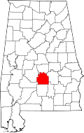 | |
| Unincorporated communities | ||