Mont-Élie, Quebec
| Mont-Élie | |
|---|---|
| Unorganized territory | |
|
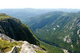
View from Acropole des Draveurs | |
 Location within Charlevoix-Est RCM. | |
 Mont-Élie Location in central Quebec. | |
| Coordinates: 47°56′N 70°21′W / 47.933°N 70.350°WCoordinates: 47°56′N 70°21′W / 47.933°N 70.350°W[1] | |
| Country |
|
| Province |
|
| Region | Capitale-Nationale |
| RCM | Charlevoix-Est |
| Constituted | unspecified |
| Government[2] | |
| • Federal riding |
Montmorency—Charlevoix —Haute-Côte-Nord |
| • Prov. riding | Charlevoix–Côte-de-Beaupré |
| Area[2][3] | |
| • Total | 882.00 km2 (340.54 sq mi) |
| • Land | 859.02 km2 (331.67 sq mi) |
| Population (2011)[3] | |
| • Total | 77 |
| • Density | 0.1/km2 (0.3/sq mi) |
| • Pop 2006-2011 |
|
| • Dwellings | 225 |
| Time zone | EST (UTC−5) |
| • Summer (DST) | EDT (UTC−4) |
| Area code(s) | 418 and 581 |
| Highways |
|
Mont-Élie is an unorganized territory in the Capitale-Nationale region of Quebec, Canada. It makes up almost 38% of the Charlevoix-Est Regional County Municipality.
The territory is home to the Grands-Ormes Ecological Reserve and part of the Hautes-Gorges-de-la-Rivière-Malbaie National Park. It is named after Mount Élie that in turn was named after Elijah. Nearby are other mountains and lakes named after Biblical prophets, such as Moses and Jeremiah. Mount Élie (47°55′28″N 70°21′30″W / 47.92444°N 70.35833°W) is one of the main summits of the mountainous highland in the east of the Charlevoix region. With an altitude of 1,021 meters (3,350 ft), it provides a great view of the vast surroundings and was formerly used as a location for fire watch. Its western slope forms the eastern boundary of the Hautes-Gorges-de-la-Rivière-Malbaie National Park, whereas its eastern side is part of ZEC Lac-au-Sable.[4]
Demographics
Population
| Historical Census Data - Mont-Élie, Quebec[5] | ||||||||||||||||||||||||||
|---|---|---|---|---|---|---|---|---|---|---|---|---|---|---|---|---|---|---|---|---|---|---|---|---|---|---|
|
|
| ||||||||||||||||||||||||
Private dwellings occupied by usual residents: 44 (total dwellings: 225)
See also
References
- ↑ Reference number 149563 of the Commission de toponymie du Québec (French)
- 1 2 Ministère des Affaires municipales, des Régions et de l'Occupation du territoire - Répertoire des municipalités: Mont-Élie
- 1 2 Statistics Canada 2011 Census - Mont-Élie census profile
- ↑ "Mont Élie" (in French). Commission de toponymie du Québec. Retrieved 2009-05-21.
- ↑ Statistics Canada: 1996, 2001, 2006, 2011 census
 |
L'Anse-Saint-Jean / Sagard | Baie-Sainte-Catherine | | |
| Lac-Pikauba | |
Saint-Siméon | ||
| ||||
| | ||||
| Saint-Urbain | Saint-Aimé-des-Lacs / Clermont | La Malbaie |
| Cities & towns | |
|---|---|
| Municipalities | |
| Parishes | |
| Unorganized territories | |
| |