Mohmand Agency
| Mohmand مومند | |
|---|---|
| Agency | |
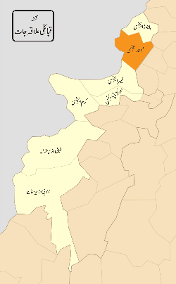 District map of FATA and Khyber-Pakhtunkhwa- Districts of FATA are shown in orange, the Mohmand Agency is located in the north. | |
| Country | Pakistan |
| Established | 1951 |
| Headquarters | Ghalanai |
| Government | |
| • Political Agent | Mr. Mehmood Aslam |
| Population (2011) | |
| • Total | 600,000 |
| Time zone | PST (UTC+5) |
| Main language(s) | Pashto, |
The Mohmand Agency (Pashto: مومند, Urdu: مہمند ایجنسی) is a district in the Federally Administered Tribal Areas of Pakistan created in 1951. Mohmand is bounded by Bajaur Agency to the north, Khyber Agency to the south, Malakand and Charsadda districts to the east and Peshawer district to the south east.
Mr. is currently the "political agent" of Mohmand Agency[1]
Population
- According to the 2011 census the population is 600,000[2] - with a population density of 171 persons per square kilometre. Momand agency is the most populous of all the Federally Administered Tribal Areas (FATA).
War on Terror
Despite its attraction to tourists, Mohmand Agency has been an area of conflict between Pakistan Army and some militant groups. In a recent exchange of fire between the two, media reported that at least 18 militants were killed and 25 others were injured.[3]
On September 16, 2011, security forces had cleared ninety percent of Mohmand Agency from the militants, normal life was restored and development activities have been launched.[4] The Pakistan Army maintains an 8,200-man presence in Mohmand Agency following military operations to clear the region of militants.[5]
In 2012, the Pakistani Army declared full control of Mohmand agency and de-notified it as conflict zone.[6]
References
- ↑ Pakistan suicide bomb attack kills dozens BBC News - December 6, 2010
- ↑ Population (FATA, 1998) - fata.gov.pk
- ↑ The News Tribe. "Forces Kill 18 militants in Mohmand Agency".
- ↑ Nation. "90% of Mohmand Agency cleared of militants; IDPs return home".
- ↑ Pak Tribune. "'Unprovoked': DGMO gives details of aerial assault".
- ↑ Dawn. "South Waziristan operation: Only Sararogha cleared in three years".
External links
Territorial capital: Parachinar | ||
| Agencies |  | |
| Frontier Regions | ||
See also: Provincially Administered Tribal Areas | ||
Coordinates: 34°30′N 71°20′E / 34.500°N 71.333°E