Merrillan, Wisconsin
| Merrillan, Wisconsin | |
|---|---|
| Village | |
|
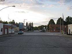
Downtown Merrillan | |
 Location of Merrillan, Wisconsin | |
| Coordinates: 44°26′58″N 90°50′15″W / 44.44944°N 90.83750°WCoordinates: 44°26′58″N 90°50′15″W / 44.44944°N 90.83750°W | |
| Country | United States |
| State | Wisconsin |
| County | Jackson |
| Area[1] | |
| • Total | 1.34 sq mi (3.47 km2) |
| • Land | 1.26 sq mi (3.26 km2) |
| • Water | 0.08 sq mi (0.21 km2) |
| Elevation[2] | 932 ft (284 m) |
| Population (2010)[3] | |
| • Total | 542 |
| • Estimate (2012[4]) | 542 |
| • Density | 430.2/sq mi (166.1/km2) |
| Time zone | Central (CST) (UTC-6) |
| • Summer (DST) | CDT (UTC-5) |
| Area code(s) | 715 & 534 |
| FIPS code | 55-51300[5] |
| GNIS feature ID | 1569372[2] |
| Website | http://www.merrillan.net |
Merrillan is a village in Jackson County, Wisconsin, United States. The population was 542 at the 2010 census.
History
A post office called Merrillan has been in operation since 1894.[6] The village was named for L. G. Merrill, an original owner of the town site.[7]
Geography
Merrillan is located at 44°26′58″N 90°50′15″W / 44.44944°N 90.83750°W (44.449528, -90.837386).[8]
According to the United States Census Bureau, the village has a total area of 1.34 square miles (3.47 km2), of which, 1.26 square miles (3.26 km2) of it is land and 0.08 square miles (0.21 km2) is water.[1]
Demographics
| Historical population | |||
|---|---|---|---|
| Census | Pop. | %± | |
| 1880 | 1,003 | — | |
| 1890 | 639 | −36.3% | |
| 1900 | 739 | 15.6% | |
| 1910 | 625 | −15.4% | |
| 1920 | 628 | 0.5% | |
| 1930 | 554 | −11.8% | |
| 1940 | 591 | 6.7% | |
| 1950 | 579 | −2.0% | |
| 1960 | 591 | 2.1% | |
| 1970 | 612 | 3.6% | |
| 1980 | 587 | −4.1% | |
| 1990 | 553 | −5.8% | |
| 2000 | 585 | 5.8% | |
| 2010 | 542 | −7.4% | |
| Est. 2015 | 533 | [9] | −1.7% |
2010 census
As of the census[3] of 2010, there were 542 people, 241 households, and 152 families residing in the village. The population density was 430.2 inhabitants per square mile (166.1/km2). There were 318 housing units at an average density of 252.4 per square mile (97.5/km2). The racial makeup of the village was 86.5% White, 2.6% Native American, 0.2% Asian, 0.4% Pacific Islander, 6.1% from other races, and 4.2% from two or more races. Hispanic or Latino of any race were 6.8% of the population.
There were 241 households of which 27.4% had children under the age of 18 living with them, 39.4% were married couples living together, 14.1% had a female householder with no husband present, 9.5% had a male householder with no wife present, and 36.9% were non-families. 31.1% of all households were made up of individuals and 15.7% had someone living alone who was 65 years of age or older. The average household size was 2.25 and the average family size was 2.70.
The median age in the village was 44.9 years. 21.4% of residents were under the age of 18; 8.7% were between the ages of 18 and 24; 20.2% were from 25 to 44; 29.6% were from 45 to 64; and 20.3% were 65 years of age or older. The gender makeup of the village was 48.2% male and 51.8% female.
2000 census
As of the census[5] of 2000, there were 585 people, 253 households, and 152 families residing in the village. The population density was 464.2 people per square mile (179.3/km²). There were 289 housing units at an average density of 229.3 per square mile (88.6/km²). The racial makeup of the village was 95.21% White, 0.68% African American, 2.74% Native American, 0.17% Asian, 0.68% from other races, and 0.51% from two or more races. Hispanic or Latino of any race were 0.68% of the population.
There were 253 households out of which 26.9% had children under the age of 18 living with them, 45.1% were married couples living together, 10.7% had a female householder with no husband present, and 39.9% were non-families. 36.4% of all households were made up of individuals and 17.0% had someone living alone who was 65 years of age or older. The average household size was 2.31 and the average family size was 2.97.
In the village the population was spread out with 23.1% under the age of 18, 8.2% from 18 to 24, 25.6% from 25 to 44, 26.2% from 45 to 64, and 16.9% who were 65 years of age or older. The median age was 39 years. For every 100 females there were 100.3 males. For every 100 females age 18 and over, there were 92.3 males.
The median income for a household in the village was $28,917, and the median income for a family was $35,000. Males had a median income of $24,423 versus $19,250 for females. The per capita income for the village was $18,811. About 10.3% of families and 13.7% of the population were below the poverty line, including 34.4% of those under age 18 and 9.6% of those age 65 or over.
Education

Merrillan is home to Lincoln Elementary School, which serves students in 4 year old kindergarten through sixth grade. It is part of the Alma Center-Humbird-Merrillan (ACHM) school district and is located 1/2 mile from the junction of Hwy 95 and Hwy 12& 27. In 1996 the old school building was torn down and a new one erected just behind where the old on stood. Several years later a 4 classroom addition was added. The building has a 4K-1st grade wing, a 2nd-4th grade wing, and a 5th-6th grade wing that includes a nicely equipped science room. In the center of the three wings in the Media Center. There is also a Lunda Commons where lunch is served and a gymnasium with locker rooms. Flag football, basketball, softball, and baseball are available for elementary students to participate in.
Notable people
- Mitchell Red Cloud, Jr. - Medal of Honor recipient
- Frederick Condit - lawyer and Independent Greenback legislator
- Alvin S. Trow - legislator
Climate
The Köppen Climate Classification subtype for this climate is "Dfb" (Warm Summer Continental Climate).[11]
| Climate data for Merrillan, Wisconsin | |||||||||||||
|---|---|---|---|---|---|---|---|---|---|---|---|---|---|
| Month | Jan | Feb | Mar | Apr | May | Jun | Jul | Aug | Sep | Oct | Nov | Dec | Year |
| Average high °C (°F) | −4 (25) |
−1 (30) |
6 (42) |
14 (58) |
22 (71) |
26 (79) |
29 (84) |
28 (82) |
23 (73) |
16 (61) |
6 (43) |
−2 (29) |
14 (57) |
| Average low °C (°F) | −17 (2) |
−15 (5) |
−8 (17) |
−1 (31) |
6 (42) |
11 (52) |
13 (56) |
12 (54) |
8 (46) |
2 (35) |
−5 (23) |
−13 (9) |
−1 (31) |
| Average precipitation cm (inches) | 3 (1) |
3 (1) |
4.6 (1.8) |
7.1 (2.8) |
9.9 (3.9) |
11.2 (4.4) |
9.4 (3.7) |
9.9 (3.9) |
9.7 (3.8) |
5.8 (2.3) |
4.6 (1.8) |
3 (1.2) |
79.8 (31.4) |
| Average precipitation days | 7 | 5 | 7 | 9 | 10 | 10 | 9 | 9 | 9 | 8 | 7 | 6 | 96 |
| Source: Weatherbase [12] | |||||||||||||
Images

 Sign marking Merrillan
 Water tower
 City welcome sign
 Village hall
References
- 1 2 "US Gazetteer files 2010". United States Census Bureau. Retrieved 2012-11-18.
- 1 2 "US Board on Geographic Names". United States Geological Survey. 2007-10-25. Retrieved 2008-01-31.
- 1 2 "American FactFinder". United States Census Bureau. Retrieved 2012-11-18.
- ↑ "Population Estimates". United States Census Bureau. Retrieved 2013-06-24.
- 1 2 "American FactFinder". United States Census Bureau. Retrieved 2008-01-31.
- ↑ "Jackson County". Jim Forte Postal History. Retrieved 4 April 2015.
- ↑ Chicago and North Western Railway Company (1908). A History of the Origin of the Place Names Connected with the Chicago & North Western and Chicago, St. Paul, Minneapolis & Omaha Railways. p. 183.
- ↑ "US Gazetteer files: 2010, 2000, and 1990". United States Census Bureau. 2011-02-12. Retrieved 2011-04-23.
- ↑ "Annual Estimates of the Resident Population for Incorporated Places: April 1, 2010 to July 1, 2015". Retrieved July 2, 2016.
- ↑ "Census of Population and Housing". Census.gov. Retrieved June 4, 2015.
- ↑ Climate Summary for Merrillan, Wisconsin
- ↑ "Weatherbase.com". Weatherbase. 2013. Retrieved on July 19, 2013.
External links
| Wikimedia Commons has media related to Merrillan, Wisconsin. |
- Alma Center-Humbird-Merrilan School District
- Sanborn fire insurance maps: 1904 1914
Municipalities and communities of Jackson County, Wisconsin, United States | ||
|---|---|---|
| City | 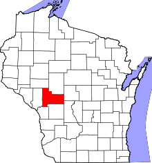 | |
| Villages | ||
| Towns | ||
| CDPs | ||
| Unincorporated communities | ||
| Ghost towns | ||
| Indian reservation | ||
| Footnotes | ‡This populated place also has portions in an adjacent county or counties | |