Mere, Belgium
| Mere | ||
|---|---|---|
| Village | ||
| Erpe-Mere in East-Flanders | ||
|
Localisation of Mere in Erpe-Mere | ||
| ||
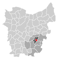 Localisation of Mere in the community of Erpe-Mere in the arrondissement of Aalst in the province of East-Flanders. | ||
| Country | Belgium | |
| Region |
| |
| Province |
| |
| Arrondissement | Aalst | |
| Municipality |
| |
| Area | ||
| • Total | 5.77 km2 (2.23 sq mi) | |
| Elevation | 0 m (0 ft) | |
| Population (2003) | ||
| • Total | 5,033 | |
| • Density | 873/km2 (2,260/sq mi) | |
| Source: NIS | ||
| Postal code | 9420 | |
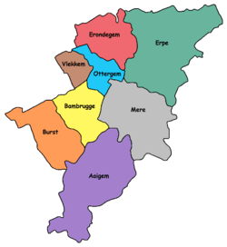

Mere is a sub-municipality of Erpe-Mere in Flanders. It is located on the Molenbeek-Ter Erpenbeek in the Denderstreek in the southeast of East Flanders and belongs to Arrondissement of Aalst. It is bordered by the sub-municipalities of Erpe, Ottergem, Bambrugge and Aaigem and the municipalities Haaltert (sub-municipality Haaltert) and Aalst (sub-municipality Nieuwerkerken). Mere has 5033 inhabitants as of 1 January 2003 and an area of 5.77 km. The population density is 873 inhabitants / km ².
History
On the opposite side of a windmill in the Jeruzalemstraat (a street), the remains of a Roman villa have been found (on the hill opposite the Merelputstraat). Mere was mentioned in a 1003 document as Meren. Perhaps the name comes from the numerous swamps (Meren in Dutch) in the neighbourhood of the village. At the beginning of the 19th Century, the village had 1874 inhabitants and at the end of the 19th Century it had 2942 inhabitants. At that time there was a windmill, three water mills and one factory, which gave 1000 people jobs. Each year around 300 people went to France to help as seasonal workers at the harvest.
Geography
The highest point of the sub-municipality Mere is on the Gotegemberg with a peak of 68 meters height. In the Diepestraat (a street) next to the windmill teeth of various marine fish, including sharks, have been found. They show that the land was pre-historically at the bottom of a sea.
Landmarks
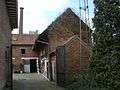 Front view of the De Graevesmolen at Mere
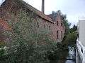 Side-view of the De Graevesmolen at Mere
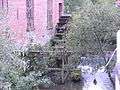 Mill wheel of the De Graevesmolen at Mere
 Gotegemmolen at Mere
 Mill wheel of the Gotegemmolen at Mere
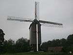 Kruiskoutermolen at Mere
 Molen te Broeck at Mere
 Mill wheel of the Molen te Broeck at Mere
 The church of Mere front view
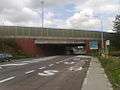 The motorway bridge (E40) of Mere over the Oudenaardsesteenweg
There are three water mills in Mere, with all of them being located on the Molenbeek Brook. They are the De Graevesmolen, the Gotegemmolen and the Molen te Broeck. On the Koudenberg, one of the highest hills of the community, there is also a windmill. It was re-mounted on its base in 2006 after it was restored in 2004 by a studio in Roeselare. The Kruiskoutermolen was restored in 2006 and is operational. It can be visited by appointment with the tourist service.
| Name(s) | Address | Type | Protected | Info |
|---|---|---|---|---|
| De Graevesmolen | Bosstraat 25 | Overshot watermill | | Wheat mill and oil mill |
| Gotegemmolen | Gotegemstraat 1 | Overshot watermill | | Wheat mill |
| Kruiskoutermolen Jezuïtenmolen Molen Van Der Haegen | Schoolstraat | Post windmill with open foot | | Wheat mill |
| Molen te Broeck 't Hof Schuurke | Wilgendries 6 | Overshot watermill | | Wheat mill |
The Sint-Baafs Church can be found in Mere. Mere belongs to deanery of Lede.
Tourism
Through Mere runs the Molenbeekroute. The Molenbeekroute is a cycle track network, known primarily for the mills of the municipality Erpe-Mere and two brooks that can be found there, both of which have the name Molenbeek (mill brook).
Sport
The football club FC Mere plays in Mere, and is currently active in the fourth provincial league of the province of East Flanders as of 2012.
| Wikimedia Commons has media related to Mere. |
| Sub-municipalities: |  | ||
|---|---|---|---|
| Hamlets: | |||
Coordinates: 50°55′20″N 3°58′17″E / 50.92222°N 3.97139°E