Mentor, Kansas
| Mentor, Kansas | |
|---|---|
| Unincorporated community | |
 Location within Saline County and Kansas | |
 KDOT map of Saline County (legend) | |
| Coordinates: 38°44′26″N 97°36′11″W / 38.74056°N 97.60306°WCoordinates: 38°44′26″N 97°36′11″W / 38.74056°N 97.60306°W | |
| Country | United States |
| State | Kansas |
| County | Saline |
| Government | |
| • Type | Unincorporated community |
| Elevation | 1,273 ft (388 m) |
| Time zone | Central Standard Time (UTC-6) |
| • Summer (DST) | Central Daylight Time (UTC-5) |
| ZIP code | 67416 |
| Area code | 785 |
Mentor is an unincorporated community in Saline County, Kansas, United States. It is part of the Salina micropolitan area.[1]
History
Mentor was named by settlers who hailed from Mentor, Ohio.[2]
Mentor had a post office between 1881 and 1995.[3]
Geography
Mentor is located at 38°44′26″N 97°36′11″W / 38.74056°N 97.60306°W, which is approximately three miles south of Salina. It has an elevation of 1,273 feet (388 m).
Education
Primary and secondary education
Mentor is part of Unified School District 306.[4][5][6]
Further reading
References
- ↑ Nussle, Jim (2008-11-20). "Micropolitan Statistical Areas" (PDF). List 1-9. Office of Management and Budget, Executive Office of the President. p. 97. Retrieved 2010-04-02.
- ↑ Heim, Michael (2007). Exploring Kansas Highways. p. 57.
- ↑ "Kansas Post Offices, 1828-1961". Kansas Historical Society. Archived from the original on October 9, 2013. Retrieved 23 June 2014.
- ↑ USD 306
- ↑ Kansas School District Boundary Map
- ↑ Saline County School District Map
External links
| Wikimedia Commons has media related to Mentor, Kansas. |
Municipalities and communities of Saline County, Kansas, United States | ||
|---|---|---|
| Cities | 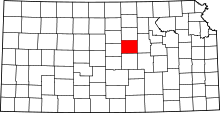 | |
| CDPs | ||
| Unincorporated communities | ||
| Townships |
| |
| Footnotes | ‡This populated place also has portions in an adjacent county or counties | |
This article is issued from Wikipedia - version of the 10/23/2016. The text is available under the Creative Commons Attribution/Share Alike but additional terms may apply for the media files.