Melas Chasma
|
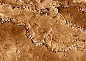
Melas Chasma in mosaic of THEMIS infrared images, with parts of Ius, Candor and Coprates chasmata visible at the upper left, top and lower right, respectively. Enormous landslide deposits are visible near the junctions of Melas Chasma with each of the neighboring chasmata. Numerous graben ("fossae") and ridges ("dorsa") stretch across the plateau outside the canyons' rims. | |
| Coordinates | 10°24′S 72°42′W / 10.4°S 72.7°WCoordinates: 10°24′S 72°42′W / 10.4°S 72.7°W |
|---|---|
| Length | 547.0 km |
Melas Chasma is a canyon on Mars, the widest segment of the Valles Marineris canyon system,[1] located east of Ius Chasma at 9.8°S, 283.6°E in Coprates quadrangle. It cuts through layered deposits that are thought to be sediments from an old lake that resulted from runoff of the valley networks to the west.[2] Other theories include windblown sediment deposits and volcanic ash.[1] Support for abundant, past water in Melas Chasma is the discovery by MRO of hydrated sulfates. In addition, sulfate and iron oxides were found by the same satellite.[3] It is one of eight potential landing sites for the Mars 2020 rover, a mission with a focus on astrobiology.
The floor of Melas Chasma is about 70% younger massive material that is thought to be volcanic ash whipped up by the wind into eolian features. It also contains rough floor material from the erosion of the canyon walls. Around the edges of Melas is also a lot of slide material.[4] This is also the deepest part of the Valles Marineris system at eleven kilometers deep from the surrounding surface, from here to the outflow channels are about a 0.03 degree slope upward to the northern plains, which means that filling the canyon with fluid would give a lake with a depth of about one kilometer before the fluid would flow out onto the northern plains.[5]
In a recent study of southwestern Melas Chasma using high-resolution image, topographic and spectral datasets eleven fan-shaped landforms were found. These fans add to growing evidence that Melas Chasma once held a lake that had fluctuating levels.[6] [7]
The canyon's depth suggests that this location may be the best site for a manned outpost as it would have the highest natural air pressure on Mars. Equatorial solar irradiation and access to water would enhance this option still further.
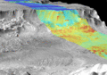 Combined infrared and daytime observation of Melas Chasma. The shadowed regions (blue) indicate successive landslides.
 Cliff in Melas Chasma, as seen by THEMIS. Click on image to see relationship of Melas to other features.
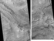 Two views of Melas Chasma Layered Deposits, as seen by HiRISE. Left picture lies north of other picture on the right. Pictures are not the same scale. Click on image to see details of layers.
 Layers in Monument Valley. These are accepted as being formed, at least in part, by water deposition. Since Mars contains similar layers, water remains as a major cause of layering on Mars.
References
- 1 2 HiRISE | Eroding Layers in Melas Chasma (PSP_004054_1675)
- ↑ HiRISE | MSL Landing Site in Melas Chasma (PSP_002828_1700)
- ↑ Murchie, S. et al. 2009. A synthesis of Martian aqueous mineralogy after 1 Mars year of observations from the Mars Reconnaissance Orbiter. Journal of Geophysical Research: 114.
- ↑ Witbeck, Tanaka and Scott, Geologic Map of the Valles Marineris Region, Mars; USGS I-2010; 1991.
- ↑ Cattermole, Peter John (2001). Mars: the mystery unfolds. Oxford University Press. p. 105. ISBN 0-19-521726-8.
- ↑ Williams, R. and C. Weitz. Reconstructing the aqueous history within the southwestern Melas basin, Mars: Clues from stratigraphic and morphometric analyses of fans. Icarus:242, 19-37.
- ↑ Davis, J., P. Grindrod, R. Williams, S. Gupta, M. Balme. 2015. STRATIGRAPHIC EVIDENCE OF EPISODIC FLUVIAL ACTIVITY IN THE SOUTH MELAS CHASMA BASIN, VALLES MARINERIS, MARS. 46th Lunar and Planetary Science Conference. 1932.pdf
See also
External links
- Metz, Joannah M.; John P. Grotzinger; David Mohrig; Ralph Milliken; Bradford Prather; Carlos Pirmez; Alfred S. McEwen & Catherine M. Weitz (2009). "Sublacustrine depositional fans in southwest Melas Chasma" (PDF). Journal of Geophysical Research. 114 (E10002). Bibcode:2009JGRE..11410002M. doi:10.1029/2009JE003365.
- Lakes on Mars - Nathalie Cabrol (SETI Talks)
| Instruments | |
|---|---|
| Features | |
| Proposed landing sites | |
| |