Arabia Terra


Arabia Terra is a large upland region in the north of Mars in that lies mostly in the Arabia quadrangle, but a small part is in the Mare Acidalium quadrangle. It is densely cratered and heavily eroded. This battered topography indicates great age, and Arabia Terra is presumed to be one of the oldest terrains on the planet. It covers as much as 4,500 km (2,800 mi) at its longest extent, centered roughly at 19°47′N 30°00′E / 19.79°N 30°E[1]Coordinates: 19°47′N 30°00′E / 19.79°N 30°E[2] with its eastern and southern regions rising 4 km (13,000 ft) above the north-west. Alongside its many craters, canyons wind through the Arabia Terra, many emptying into the large northern lowlands of the planet, which borders Arabia Terra to the north.
Features
Arabia contains many interesting features. There are some good examples of pedestal craters in the area. A pedestal crater has its ejecta above the surrounding terrain, often forming a steep cliff. The ejecta forms a resistant layer that protects the underlying material from erosion.[3] Mounds and buttes on the floor of some craters display many layers. The layers may have formed by volcanic processes, by wind, or by underwater deposition.[4][5] Dark slope streaks have been observed in Tikhonravov Basin, a large eroded crater. The streaks appear on steep slopes and change over time. At first they are dark, then turn a lighter color, probably by the deposition of fine, light colored dust from the atmosphere.[6] These streaks are thought to form by dust moving downslope in a way similar to snow avalanches on Earth.[7]
Arabia Terra was named in 1879 after a corresponding albedo feature on a map by Giovanni Schiaparelli, who named it in turn after the Arabian peninsula.
Possible tectonism
Research on the region was undertaken in 1997 and the individuality of the province better defined.[8] An equatorial belt was noted with a crater age distinctly younger than the northern part of the province and of Noachis Terra to the south. This was interpreted as an "incipient back-arc system" provoked by the subduction of Mars lowlands under Arabia Terra during Noachian times. Regional fracture patterns were also explained in this manner, and the rotational instability of the planet as a cause was not supported. It contains extension tectonic features[9]
Possible volcanism
A 2013 study proposed that a number of craters within Arabia Terra, including Eden Patera,[10] Euphrates Patera,[11] Siloe Patera,[12] and possibly Semeykin crater,[13] Ismenia Patera,[14] Oxus Patera[15] and Oxus Cavus,[16] represent calderas formed by massive explosive volcanic eruptions[17] (supervolcanoes)[18] of Late Noachian to Early Hesperian age.[19] Termed "plains-style caldera complexes", these very low relief volcanic features appear to be older than the large Hesperian-age shield volcanoes of Tharsis or Elysium. Eden Patera, for example, is an irregular, 55 by 85 km depression up to 1.8 km deep, surrounded by ridged basaltic plains. It contains three linked interior depressions, demarcated by arcuate scarps, that have terraces suggestive of lava lake drainage and faults suggestive of collapse. The features indicative of impact origin that would be expected in an impact crater of comparable diameter and depth are absent.[19] The authors regard crustal thinning due to regional extension to be a more likely explanation for the origin of the volcanic activity than putative subduction.[19] Rapid ascent of magma through the thin crust and a consequent relative absence of degassing may explain the more explosive eruption style associated with these paterae relative to that of the shield volcanoes. The eruptions would have contributed to the layered deposits of Arabia Terra, which are among the fine-grained deposits widespread in the equatorial regions of Mars. Total eruptive volumes of at least 4,600–7,200 km3 per caldera complex (over its history) were inferred.[19]
Recent meteoroid impact
A meteorite impacted in Arabia Terra some time between 30 June 2002 and 5 October 2003. A single small crater of about 22.6 meters (about 74 feet) in diameter is surrounded by light and dark-toned ejecta - indicating that this impact excavated to a depth where light colored strata exists. The crater occurs near 20.6 degrees north latitude, 356.8 degrees west longitude, in Arabia Terra. Images of the area show how the impact site appeared to the Mars Odyssey Thermal Emission Imaging System infrared instrument before and after the impact.[20]
In popular culture
In the novel The Martian by Andy Weir, the protagonist encounters a dust storm in Arabia Terra while traveling from Acidalia Planitia to Schiaparelli crater.[21]
Layers
Many places on Mars show rocks arranged in layers. Rock can form layers in a variety of ways. Volcanoes, wind, or water can produce layers.[22] Layers may be formed by groundwater rising up depositing minerals and cementing sediments. The hardned layers are consequently more protected from erosion. This process may occur instead of layers forming under lakes.
A detailed discussion of layering with many Martian examples can be found in Sedimentary Geology of Mars.[23]
-

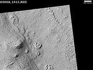
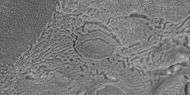
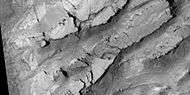
Layers in Tikonravev Crater in Arabia, as seen by Mars Global Surveyor (MGS). Layers may form from volcanoes, the wind, or by deposition under water. The craters on the left are pedestal craters. Some researchers believe this crater once held a massive lake.
-

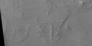
Tikonravev Crater floor, as seen by Mars Global Surveyor. Click on image to see dark slope streaks and layers.
-

Tikhonravov Basin streaks, as seen by HiRISE. Scale bar is 500 m (1,600 ft) long
-

Layers in Monument Valley, Arizona. These are accepted as being formed, at least in part, by water deposition. Since Mars contains similar layers, water is considered a major cause of layering on Mars.
-
Henry Crater mound, as seen by HiRISE. The scale bar is 500 m (1,600 ft) long
-
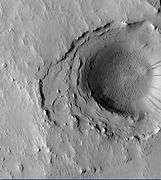
Crater in the middle of Cassini, as seen by HiRISE. Layers may have been deposited under water since it is believed that Cassini once held a giant lake.
-

Buttes, as seen by HiRISE under HiWish program. Buttes have layered rocks with a hard resistant cap rock on the top which protects the underlying rocks from erosion.
-

Possible dikes and layered structures, as seen by HiRISE under HiWish program.
-

Possible fault along a butte, as seen by HiRISE under HiWish program.
Channels
Many places on Mars show channels of different sizes. Many of these channels probably carried water, at least for a time. One study that used HiRISE pictures found over 17,000 km of ancient river valleys in Arabia Terra.[24][25] Many ancient river valleys have been determined to be relatively recent, according to research published in 2016 in the Journal of Geophysical Research: Planets. These valleys carried water into lake basins. One lake, nicknamed "Heart Lake," had a volume similar to Lake Ontario.[26][27] The climate of Mars may have been such in the past that water ran on its surface. It has been known for some time that Mars undergoes many large changes in its tilt or obliquity because its two small moons lack the gravity to stabilize it, as our moon stabilizes Earth; at times the tilt has even been greater than 80 degrees[28][29]
-

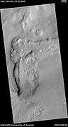
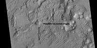
Channels in Arabia, as seen by CTX This channel winds along for a good distance and has branches. It ends in a depression that may have been a lake at one time.
-

Channel in Arabia, as seen by HiRISE under HiWish program.
-

Channel within larger channel, as seen by HiRISE under HiWish program The existence of the smaller channel suggests water went through the region at least two times in the past.
-

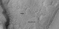
Close-up of channel within larger channel, as seen by HiRISE under HiWish program The existence of the smaller channel suggests water went through the region at least two times in the past. The black box represents the size of a football field. Some parts of the surface would be difficult to walk on with the many small hills and depressions.
-

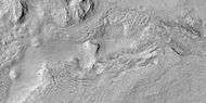
Sklodowska (Martian crater), as seen by CTX camera (on Mars Reconnaissance Orbiter). Small channels are visible along the eroded, southern rim.
-

Channels in Sklodowska Crater, as seen by CTX camera (on Mars Reconnaissance Orbiter). Note: this is an enlargement of the previous image.
-

Channels in Sklodowska Crater, as seen by HiRISE under the HiWish program.
-

Channel system that travels through part of a crater, as seen by HiRISE under HiWish program
Upper Plains Unit
Parts of northern Arabia Terra contains the upper plains unit. The Upper Plains Unit is the remnants of a 50-100 meter thick mantling in the mid-latitudes. It was first investigated in the Deuteronilus Mensae (Ismenius Lacus quadrangle) region, but it occurs in other places as well. The remnants consist of sets of dipping layers in craters and along mesas.[30]
-
Wide view of dipping layers, upper plains unit, and brain terrain, as seen by HiRISE under HiWish program
-

Dipping layers, as seen by HiRISE under HiWish program This is an enlargement of a previous image.
Some regions of the upper plains unit display large fractures and troughs with raised rims; such regions are called ribbed upper plains. Fractures are believed to have started with small cracks from stresses. Stress is suggested to initiate the fracture process since ribbed upper plains are common when debris aprons come together or near the edge of debris aprons—such sites would generate compressional stresses. Cracks exposed more surfaces, and consequently more ice in the material sublimates into the planet’s thin atmosphere. Eventually, small cracks become large canyons or troughs.
-

View of stress cracks and larger cracks that have been enlarged by sublimation (ice changing directly into gas) This may be the start of ribbed terrain.
-

Evolution of ribbed terrain from stress cracks—cracks to the left eventually will enlarge and become ribbed terrain toward the right side of picture, as seen by HiRISE under HiWish program
This unit also degrades into brain terrain. Brain terrain is a region of maze-like ridges 3–5 meters high. Some ridges may consist of an ice core, so they may be sources of water for future colonists.
-
Brain terrain is forming from the breakdown of upper plains unit, as seen by HiRISE under HiWish program Arrow points to a place where fractures are forming that will turn into brain terrain.
-

Brain terrain is forming from the breakdown of upper plains unit, as seen by HiRISE under HiWish program Arrow points to a place where fractures are forming that will turn into brain terrain.
-

Wide view of brain terrain being formed, as seen by HiRISE under HiWish program
-
Brain terrain being formed, as seen by HiRISE under HiWish program Note: this is an enlargement of the previous image using HiView.
-

Brain terrain being formed, as seen by HiRISE under HiWish program Note: this is an enlargement of a previous image using HiView.
Linear ridge networks
Linear ridge networks are found in various places on Mars in and around craters.[31] Ridges often appear as mostly straight segments that intersect in a lattice-like manner. They are hundreds of meters long, tens of meters high, and several meters wide. It is thought that impacts created fractures in the surface, these fractures later acted as channels for fluids. Fluids cemented the structures. With the passage of time, surrounding material was eroded away, thereby leaving hard ridges behind. Since the ridges occur in locations with clay, these formations could serve as a marker for clay which requires water for its formation.[32][33][34] Water here could have supported past life in these locations. Clay may also preserve fossils or other traces of past life.
-

Linear ridge network, as seen by HiRISE under HiWish program Dark line is not part of the picture. Data was not gathered for that area.
-
Enlargement of previous image of linear ridge network, as seen by HiRISE under HiWish program
Pingos
Pingos are believed to be present on Mars. They are mounds that contain cracks. They contain pure water ice, so they would be a great source of water for future colonists on Mars
-
Arrows point to possible pingos, as seen by HiRISE under HiWish program Pingos contain a core of pure ice.
Mesas
-

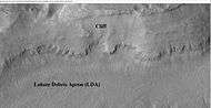
Wide view of mesa with CTX showing cliff face and location of lobate debris apron (LDA). Location is Ismenius Lacus quadrangle.
-
Enlargement of previous CTX image of mesa This image shows the cliff face and detail in the LDA. Image taken with HiRISE under HiWish program. Location is Ismenius Lacus quadrangle.
-

Large group of concentric cracks, as seen by HiRISE, under HiWish program. These may have formed when ice under this place disappeared from the ground.
-

Tilted layers formed when ground collapsed, as seen by HiRISE, under HiWish program.
-

Tilted layers formed from ground collapse, as seen by HiRISE, under HiWish program.
-
Mesas breaking up into blocks, as seen by HiRISE, under HiWish program.
-

Enlarged view of a group of mesas, as seen by HiRISE under HiWish program One surface is forming square shapes.
-

Mesa, as seen by HiRISE under HiWish program This may make for a good race around a mesa someday in the far future.
Fractures forming blocks
In places large fractures break up surfaces. Sometimes straight edges are formed and large cubes are created by the fractures.
-

Wide view of mesas that are forming fractures, as seen by HiRISE under HiWish program.
-
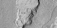
Enlarged view of a part of previous image, as seen by HiRISE under HiWish program. The rectangle represents the size of a football field.
-

Close-up of blocks being formed, as seen by HiRISE under HiWish program as seen by HiRISE under HiWish program.
-

Close-up of blocks being formed, as seen by HiRISE under HiWish program The rectangle represents the size of a football field, so blocks are the size of buildings.
-

Close-up of blocks being formed, as seen by HiRISE under HiWish program as seen by HiRISE under HiWish program. Many long fractures are visible on the surface.
-
Surface breaking up, as seen by HiRISE under HiWish program as seen by HiRISE under HiWish program. Near the top the surface is eroding into brain terrain.
-

Wide view showing light-toned feature that is breaking into blocks, as seen by HiRISE under HiWish program
-

Close view showing blocks being formed, as seen by HiRISE under HiWish program Note: this is an enlargement of the previous image. Box represents size of football field.
Glaciers
-

Wide view of flow moving down valley, as seen by HiRISE under HiWish program Location is Ismenius Lacus quadrangle.
-

Close view of part of glacier, as seen by HiRISE under HiWish program Box shows size of football field.
-

Close view of mantle, as seen by HiRISE under HiWish program Arrows show craters along edge which highlight the thickness of mantle.
Gallery
-
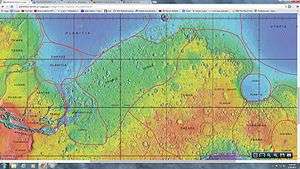
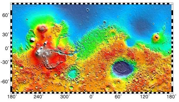
MOLA map showing boundaries for Arabia Terra and other nearby regions.
-

An oblique view of Arabia Terra produced by Mars Global Surveyor
-

Pasteur Crater floor, as seen by HiRISE. The scale bar is 1,000 m (3,300 ft) long
-
Close view of mantle, as seen by HiRISE under HiWish program Arrows show craters along edge which highlight the thickness of mantle.
-

Pits and troughs, as seen by HiRISE under HiWish program Pits may have formed from water/ice leaving the ground.
Interactive Mars map
See also
- Geography of Mars
- List of quadrangles on Mars
- Climate of Mars
- Geology of Mars
- Impact crater
- List of craters on Mars
References
- ↑ "Arabia Terra". Gazetteer of Planetary Nomenclature. USGS Astrogeology Research Program.
- ↑ "Arabia Terra". Gazetteer of Planetary Nomenclature. USGS Astrogeology Research Program.
- ↑ http://hirise.lpl.arizona.edu/PSP_008508_1870
- ↑ http://hirise.lpl.arizona.edu/PSP_009008_1915
- ↑ http://hirise.lpl.arizona.edu/PSP_004434_1885
- ↑ http://hirise.lpl.arizona.edu/PSP_007531_1935
- ↑ http://hirise.lpl.arizona.edu/PSP_006569_1915
- ↑ Anguita, F.; et al. (1997). "Arabia Terra, Mars: Tectonic and Palaeoclimatic Evolution of a Remarkable Sector of Martian Lithosphere". Earth, Moon, and Planets. 77 (1): 55. Bibcode:1997EM&P...77...55A. doi:10.1023/A:1006143106970.
- ↑ Brugman, K., B. Hynek, S. Robbins. 2015. CRATER-BASED TESTS UNLOCK THE MYSTERY OF THE ORIGIN AND EVOLUTION OF ARABIA TERRA, MARS. Lunar and Planetary Science Conference 2359.pdf
- ↑ "Eden Patera". USGS planetary nomenclature page. USGS. Retrieved 2013-10-17. External link in
|work=(help) - ↑ "Euphrates Patera". USGS planetary nomenclature page. USGS. Retrieved 2013-10-17. External link in
|work=(help) - ↑ "Siloe Patera". USGS planetary nomenclature page. USGS. Retrieved 2013-10-17. External link in
|work=(help) - ↑ "Semeykin". USGS planetary nomenclature page. USGS. Retrieved 2013-10-17. External link in
|work=(help) - ↑ "Ismenia Patera". USGS planetary nomenclature page. USGS. Retrieved 2013-10-17. External link in
|work=(help) - ↑ "Oxus Patera". USGS planetary nomenclature page. USGS. Retrieved 2013-10-17. External link in
|work=(help) - ↑ "Oxus Cavus". USGS planetary nomenclature page. USGS. Retrieved 2013-10-17. External link in
|work=(help) - ↑ Witze, A. (2013). "Ancient supervolcanoes revealed on Mars". Nature. doi:10.1038/nature.2013.13857.
- ↑ Brian Wu (25 May 2015). "European Space Agency May Have Discovered a Supervolcano on Mars". Science Times.
- 1 2 3 4 Michalski, J. R.; Bleacher, J. E. (2013). "Supervolcanoes within an ancient volcanic province in Arabia Terra, Mars". Nature. 502 (7469): 47–52. Bibcode:2013Natur.502...47M. doi:10.1038/nature12482.
- ↑ http://www.nasa.gov/mission_pages/mars/images/pia09025.html#.UpGYneIe2E8
- ↑ Weir, Andy (2014). The Martian. New York: Crown Publishers. ISBN 978-0-8041-3902-1.
- ↑ "HiRISE | High Resolution Imaging Science Experiment". Hirise.lpl.arizona.edu?psp_008437_1750. Retrieved 2012-08-04.
- ↑ Grotzinger, J. and R. Milliken (eds.). 2012. Sedimentary Geology of Mars. SEPM.
- ↑ http://spaceref.com/mars/fossilized-rivers-suggest-mars-was-once-warm-and-wet.html
- ↑ Davis, J., M. Balme, P. Grindrod, R. Williams, S. Gupta. 2016. Extensive Noachian Fluvial Systems in Arabia Terra: Implications for Early Martian Climate. Geology .
- ↑ https://www.sciencedaily.com/releases/2016/09/160915142043.htm
- ↑ 1.Sharon A. Wilson, Alan D. Howard, Jeffrey M. Moore, John A. Grant. A Cold-Wet Mid-Latitude Environment on Mars during the Hesperian-Amazonian Transition: Evidence from Northern Arabia Valleys and Paleolakes. Journal of Geophysical Research: Planets, 2016; DOI: 10.1002/2016JE005052
- ↑ name= Touma J. and J. Wisdom. 1993. The Chaotic Obliquity of Mars. Science 259, 1294-1297.
- ↑ Laskar, J., A. Correia, M. Gastineau, F. Joutel, B. Levrard, and P. Robutel. 2004. Long term evolution and chaotic diffusion of the insolation quantities of Mars. Icarus 170, 343-364.
- ↑ Carr, M. 2001.
- ↑ Head, J., J. Mustard. 2006. Breccia dikes and crater-related faults in impact craters on Mars: Erosion and exposure on the floor of a crater 75 km in diameter at the dichotomy boundary, Meteorit. Planet Science: 41, 1675-1690.
- ↑ Mangold et al. 2007. Mineralogy of the Nili Fossae region with OMEGA/Mars Express data: 2. Aqueous alteration of the crust. J. Geophys. Res., 112, doi:10.1029/2006JE002835.
- ↑ Mustard et al., 2007. Mineralogy of the Nili Fossae region with OMEGA/Mars Express data: 1. Ancient impact melt in the Isidis Basin and implications for the transition from the Noachian to Hesperian, J. Geophys. Res., 112.
- ↑ Mustard et al., 2009. Composition, Morphology, and Stratigraphy of Noachian Crust around the Isidis Basin, J. Geophys. Res., 114, doi:10.1029/2009JE003349.
External links
| Wikimedia Commons has media related to Arabia Terra. |