McLeansboro Township, Hamilton County, Illinois
| McLeansboro Township | |
|---|---|
| Township | |
 Location in Hamilton County | |
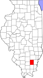 Hamilton County's location in Illinois | |
| Coordinates: 38°04′52″N 88°32′27″W / 38.08111°N 88.54083°WCoordinates: 38°04′52″N 88°32′27″W / 38.08111°N 88.54083°W | |
| Country |
|
| State |
|
| County | Hamilton |
| Established | November 3, 1885 |
| Area | |
| • Total | 35.92 sq mi (93.0 km2) |
| • Land | 35.6 sq mi (92 km2) |
| • Water | 0.32 sq mi (0.8 km2) 0.89% |
| Elevation | 446 ft (136 m) |
| Population (2010) | |
| • Total | 3,830 |
| • Density | 107.6/sq mi (41.5/km2) |
| Time zone | CST (UTC-6) |
| • Summer (DST) | CDT (UTC-5) |
| ZIP code | 62859 |
| GNIS feature ID | 0429303 |
McLeansboro Township is one of twelve townships in Hamilton County, Illinois, USA. As of the 2010 census, its population was 3,830 and it contained 1,907 housing units.[1]
Geography
According to the 2010 census, the township has a total area of 35.92 square miles (93.0 km2), of which 35.6 square miles (92 km2) (or 99.11%) is land and 0.32 square miles (0.83 km2) (or 0.89%) is water.[1]
Cities, towns, villages
Unincorporated towns
- Diamond City at 38°05′21″N 88°33′09″W / 38.089215°N 88.552553°W
- Hoodville at 38°02′57″N 88°31′38″W / 38.049214°N 88.527274°W
(This list is based on USGS data and may include former settlements.)
Cemeteries
The township contains these seven cemeteries: Concord, Crisel, Glenview Memorial Gardens, Hutson, Independent Order of Oddfellows, Presley and Union Hill.
Airports and landing strips
- McLeansboro Airport
School districts
- Hamilton County Community Unit School District 10
Political districts
- Illinois's 19th congressional district
- State House District 117
- State House District 118
- State Senate District 59
References
- "McLeansboro Township, Hamilton County, Illinois". Geographic Names Information System. United States Geological Survey. Retrieved 2010-07-06.
- United States Census Bureau 2009 TIGER/Line Shapefiles
- United States National Atlas
- 1 2 "Population, Housing Units, Area, and Density: 2010 - County -- County Subdivision and Place -- 2010 Census Summary File 1". United States Census. Retrieved 2013-05-28.
External links
- City-Data.com
- Illinois State Archives
- Township Officials of Illinois
- Hamilton County Historical Society
 |
Dahlgren Township | South Crouch Township | Beaver Creek Township | |
| Knights Prairie Township | |
Crook Township | ||
| ||||
| | ||||
| Flannigan Township | Twigg Township | Mayberry Township |
Municipalities and communities of Hamilton County, Illinois, United States | ||
|---|---|---|
| Cities | ||
| Town | ||
| Villages | ||
| Townships | ||
| Unincorporated communities |
| |
| Footnotes | ‡This populated place also has portions in an adjacent county or counties | |
This article is issued from Wikipedia - version of the 9/10/2016. The text is available under the Creative Commons Attribution/Share Alike but additional terms may apply for the media files.