McIntosh, Florida
| McIntosh, Florida | |
|---|---|
| Town | |
|
Town hall | |
 Location in Marion County and the state of Florida | |
| Coordinates: 29°26′58″N 82°13′14″W / 29.44944°N 82.22056°WCoordinates: 29°26′58″N 82°13′14″W / 29.44944°N 82.22056°W | |
| Country |
|
| State |
|
| County | Marion |
| Area | |
| • Total | 0.7 sq mi (1.8 km2) |
| • Land | 0.7 sq mi (1.8 km2) |
| • Water | 0 sq mi (0 km2) |
| Elevation | 108 ft (33 m) |
| Population (2000) | |
| • Total | 453 |
| • Density | 647.1/sq mi (251.7/km2) |
| Time zone | Eastern (EST) (UTC-5) |
| • Summer (DST) | EDT (UTC-4) |
| ZIP code | 32664 |
| Area code(s) | 352 |
| FIPS code | 12-42150[1] |
| GNIS feature ID | 0286619[2] |
| Website | http://www.townofmcintosh.org/ |

McIntosh is a town in Marion County, Florida, in the United States. As of the 2000 census, the town population was 453. As of 2004, the population recorded by the U.S. Census Bureau is 486 . It is part of the Ocala Metropolitan Statistical Area.
History
McIntosh was platted in 1885, and named in honor of Col. John C. McIntosh, an early settler.[3] A post office has been in operation at McIntosh since 1887.[4]
Geography
McIntosh is located at 29°26′58″N 82°13′14″W / 29.449322°N 82.220668°W.[5]
According to the United States Census Bureau, the town has a total area of 0.7 square miles (1.8 km2), all land.
Demographics
| Historical population | |||
|---|---|---|---|
| Census | Pop. | %± | |
| 1920 | 440 | — | |
| 1930 | 272 | −38.2% | |
| 1940 | 397 | 46.0% | |
| 1950 | 247 | −37.8% | |
| 1960 | 258 | 4.5% | |
| 1970 | 287 | 11.2% | |
| 1980 | 404 | 40.8% | |
| 1990 | 411 | 1.7% | |
| 2000 | 453 | 10.2% | |
| 2010 | 452 | −0.2% | |
| Est. 2015 | 461 | [6] | 2.0% |
As of the census[1] of 2000, there were 453 people, 227 households, and 133 families residing in the town. The population density was 650.8 inhabitants per square mile (249.9/km²). There were 271 housing units at an average density of 389.4 per square mile (149.5/km²). The racial makeup of the town was 96.91% White, 2.43% African American, 0.22% Native American, and 0.44% from two or more races. Hispanic or Latino of any race were 1.55% of the population.
There were 227 households out of which 11.9% had children under the age of 18 living with them, 52.9% were married couples living together, 5.3% had a female householder with no husband present, and 41.4% were non-families. 34.8% of all households were made up of individuals and 16.3% had someone living alone who was 65 years of age or older. The average household size was 2.00 and the average family size was 2.53.
In the town the population was spread out with 13.2% under the age of 18, 3.5% from 18 to 24, 19.2% from 25 to 44, 38.4% from 45 to 64, and 25.6% who were 65 years of age or older. The median age was 53 years. For every 100 females there were 81.2 males. For every 100 females age 18 and over, there were 81.1 males.
The median income for a household in the town was $36,250, and the median income for a family was $58,500. Males had a median income of $33,750 versus $20,500 for females. The per capita income for the town was $20,617. About 2.7% of families and 6.3% of the population were below the poverty line, including none of those under age 18 and 14.5% of those age 65 or over.
References
- 1 2 "American FactFinder". United States Census Bureau. Retrieved 2008-01-31.
- ↑ "US Board on Geographic Names". United States Geological Survey. 2007-10-25. Retrieved 2008-01-31.
- ↑ Pyle, Nancy (May 14, 1987). "County's history reflected in its names". Ocala Star-Banner. pp. 8A. Retrieved 30 May 2015.
- ↑ "Marion County". Jim Forte Postal History. Retrieved 30 May 2015.
- ↑ "US Gazetteer files: 2010, 2000, and 1990". United States Census Bureau. 2011-02-12. Retrieved 2011-04-23.
- ↑ "Annual Estimates of the Resident Population for Incorporated Places: April 1, 2010 to July 1, 2015". Retrieved July 2, 2016.
- ↑ "Census of Population and Housing". Census.gov. Archived from the original on May 11, 2015. Retrieved June 4, 2015.
External links
Municipalities and communities of Marion County, Florida, United States | ||
|---|---|---|
| Cities | 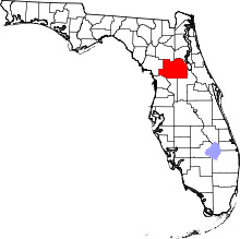 | |
| Towns | ||
| CDPs | ||
| Unincorporated communities |
| |
| Footnotes | ‡This populated place also has portions in an adjacent county or counties | |