McGrady, North Carolina
| McGrady, North Carolina | |
|---|---|
| Unincorporated community | |
 McGrady, North Carolina  McGrady, North Carolina | |
| Coordinates: 36°20′36″N 81°13′29″W / 36.34333°N 81.22472°WCoordinates: 36°20′36″N 81°13′29″W / 36.34333°N 81.22472°W | |
| Country | United States |
| State | North Carolina |
| County | Wilkes |
| Elevation | 1,732 ft (528 m) |
| Time zone | Eastern (EST) (UTC-5) |
| • Summer (DST) | EDT (UTC-4) |
| ZIP code | 28649 |
| Area code(s) | 336 |
| GNIS feature ID | 1023357[1] |
McGrady is an unincorporated community in Wilkes County, North Carolina, United States. McGrady is located along North Carolina Highway 18, 14 miles (23 km) north-northwest of Wilkesboro. McGrady has a post office with ZIP code 28649.[2][3] McGrady is located at the base of the Blue Ridge Mountains; the Blue Ridge dominate the community's northern horizon. McGrady consists of numerous valleys with creeks and streams, lower mountain ridges, farms, and forests. The largest stream in the community is Mulberry Creek, which flows south to the Yadkin River, Wilkes County's largest river.
References
- ↑ "McGrady". Geographic Names Information System. United States Geological Survey.
- ↑ United States Postal Service (2012). "USPS - Look Up a ZIP Code". Retrieved 2012-02-15.
- ↑ "Postmaster Finder - Post Offices by ZIP Code". United States Postal Service. Retrieved March 6, 2014.
Municipalities and communities of Wilkes County, North Carolina, United States | ||
|---|---|---|
| Towns | 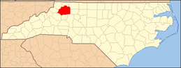 | |
| CDPs | ||
| Unincorporated communities | ||
| Footnotes | ‡This populated place also has portions in an adjacent county or counties | |
This article is issued from Wikipedia - version of the 7/27/2016. The text is available under the Creative Commons Attribution/Share Alike but additional terms may apply for the media files.