May Hill
| May Hill | |
|---|---|
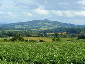 May Hill from Perrystone Hill | |
| Highest point | |
| Elevation | 296 m (971 ft) |
| Prominence | c. 217 m |
| Parent peak | Worcestershire Beacon |
| Listing | Marilyn |
| Geography | |
| Location | Gloucestershire, England |
| OS grid | SO695213 |
| Topo map | OS Landranger 162 |
May Hill is a hill between Gloucester and Ross-on-Wye. Its summit is on the western edge of Gloucestershire, though its northern slopes are in Herefordshire. The hill is made distinctive by a clump of trees on its top.[1]
Toponymy
There is an unverified story that May Hill was named after a certain Captain May who used it as a landmark when navigating the Severn estuary, but documents from a couple of hundred years ago relate that the hill was known as Yartleton Hill and was renamed because of the May Day events held there.[2] Each May Day, morris dancers dance in the new dawn on the top of May Hill and hundreds of observers join in the celebration.[3] A ceremony on May Day morning has been carried out for several centuries; originally it included a mock battle between youths.[2]
Geography

May Hill forms part of a low range of hills separating the River Severn from the River Wye. The summit is 296 metres (971 ft) above sea level, and located there among the trees are several benches from which one may study the views, which are extensive in all directions. They include views to the Welsh borders, and the lower reaches of the River Severn, bypassed for shipping by the Gloucester and Sharpness Canal.[3]
Geology
May Hill is formed of sandstones and siltstones known as the May Hill sandstone, consisting of the Huntley Hill and Yartleton formations. These rocks date from the Early Silurian period and are formed into a dome, cut through by several faults. The most significant of these is the Blaisdon Fault, which forms the eastern boundary of May Hill and separates it from the younger rocks of the Severn Vale.[4]
Ecology and SSSI status
| Site of Special Scientific Interest | |
|
Trees on the summit of May Hill | |
 Location within Gloucestershire | |
| Area of Search | Gloucestershire |
|---|---|
| Grid reference | SO695214 |
| Coordinates | 51°53′27″N 2°26′38″W / 51.890765°N 2.443869°WCoordinates: 51°53′27″N 2°26′38″W / 51.890765°N 2.443869°W |
| Interest | Biological/Geological |
| Area | 32.6 hectare |
| Notification | 1954 |
| Natural England website | |

The top of May Hill (grid reference SO695214) is a 32.6-hectare (81-acre) biological and geological Site of Special Scientific Interest in Gloucestershire, notified in 1954.[5][6]
The site is listed in the Forest of Dean Local Plan Review as a Key Wildlife Site (KWS).[7]
Much of the Hill is wooded, both coniferous and deciduous, though the summit area is grassland and heath, with a small amount of heather and gorse. The immediate summit is topped with mature Corsican pines, which were planted in 1887 to mark Queen Victoria's Golden Jubilee and one very old Scots Pine which is a generation older, but which regrettably suffered badly in an ice storm in early 2012.[1] For more info see http://notabletrees.blogspot.co.uk/ These trees make May Hill an easily identifiable landmark from many miles away. The younger trees around were planted to mark Queen Elizabeth's Silver Jubilee. Early maps and accounts show a clump of trees on the top before these plantings.[2] Birds to be seen on the hill include meadow pipit, tree pipit,[8] redstart and raven, whilst the woods below have a good population of woodcock.
History
An area of 30 ha of the hill is owned by the National Trust,[1] though the very top is vested with Longhope Parish Council and registered as a Village Green. The site boundary was amended in 1983.[5] The hill includes a circular trench 100 metres in diameter said to be an Iron Age earthwork, surrounding a mound that is probably a round barrow. The hill was enclosed by an act of parliament in 1873 and passed into the care of the National Trust in 1935.[2]
There are records of a clump of trees on the summit of May Hill dating back to the later 18th century. The dwindling clump was replenished in time for the Golden Jubilee of Queen Victoria in 1887.[2] There was further replenishment 90 years later. A plaque on the summit commemorating the Silver Jubilee of Elizabeth II in 1977 reads; "This plaque was erected by the parishes of Longhope & Newent as a tribute to a gracious and beloved monarch. God Save the Queen".[3] The summit is reached by three public footpaths, two of them forming parts of the Gloucestershire Way and Wysis Way.[8]
May Hill in cultural life
John Masefield describes May Hill in his poem "The Everlasting Mercy".[9] Ivor Gurney eulogised "May Hill that Gloucester dwellers 'gainst every sunset see". Composer Gerald Finzi's ashes were scattered on the top in 1973[10] as have been the ashes of other local residents. One of the benches on the summit is dedicated to the Forest of Dean chronicler Winifred Foley and her husband, who moved in the 1970s to the nearby village of Cliffords Mesne.
References
- 1 2 3 "May Hill – Visitor Information – National Trust". National Trust. Retrieved 22 June 2012.
- 1 2 3 4 5 "May Hill". www.longhopevillage.co.uk. Retrieved 22 June 2012. External link in
|publisher=(help) - 1 2 3 "May Hill". www.wyenot.com. Retrieved 22 June 2012. External link in
|publisher=(help) - ↑ "Gloucestershire Geology Trust". Gloucestershire Geology Trust. Retrieved 22 June 2012. External link in
|publisher=(help) - 1 2 Natural England SSSI information on citation, map and unit details.
- ↑ Forest of Dean District Local Plan Review, adopted November 2005, Appendix D 'Nature Conservation Site Designations Within the Forest of Dean District', Sites of Special Scientific Interest
- ↑ Forest of Dean District Local Plan Review, adopted November 2005, Appendix D 'Nature Conservation Site Designations Within the Forest of Dean District', Key Wildlife Sites
- 1 2 "May Hill countryside walk" (PDF). National Trust. Retrieved 22 June 2012.
- ↑ "May Hill Forest of Dean website". Forest of Dean Tourist Information Official Site. Retrieved 18 December 2011. External link in
|publisher=(help) - ↑ Diana M. McVeagh: Gerald Finzi: his life and music (Woodbridge, Suffolk: Boydell Press, 2005), p. 251.
External links
- Photos of May Hill on www.geograph.org.uk
- Photos of May Hill on www.wyenot.com
- Panoramic view of May Hill
- Video of May Day sunrise celebration on May Hill (2010)
- Natural England (SSSI information)