Maxville, Montana
| Maxville, Montana | |
|---|---|
| Census-designated place | |
 Maxville  Maxville | |
| Coordinates: 46°27′53″N 113°14′03″W / 46.46472°N 113.23417°WCoordinates: 46°27′53″N 113°14′03″W / 46.46472°N 113.23417°W | |
| Country | United States |
| State | Montana |
| County | Granite |
| Area[1] | |
| • Total | 6.924 sq mi (17.93 km2) |
| • Land | 6.915 sq mi (17.91 km2) |
| • Water | 0.009 sq mi (0.02 km2) |
| Elevation | 4,839 ft (1,475 m) |
| Population (2010)[1] | |
| • Total | 130 |
| • Density | 19/sq mi (7.2/km2) |
| Time zone | Mountain (MST) (UTC-7) |
| • Summer (DST) | MDT (UTC-6) |
| Area code(s) | 406 |
| GNIS feature ID | 786949[2] |
Maxville is an unincorporated community and census-designated place in Granite County, Montana, United States. Its population was 130 as of the 2010 census.[1] Montana Highway 1 passes through the community.
Geography
Maxville is located at 32°51′40″N 104°23′49″W / 32.861009°N 104.397071°W. According to the U.S. Census Bureau, the community has an area of 6.924 square miles (17.93 km2), of which 6.915 square miles (17.91 km2) is land and 0.009 square miles (0.023 km2) is water.[1]
References
- 1 2 3 4 "2010 Census Gazetteer Files - Places: Montana". U.S. Census Bureau. Retrieved April 24, 2016.
- ↑ "Maxville". Geographic Names Information System. United States Geological Survey.
Municipalities and communities of Granite County, Montana, United States | ||
|---|---|---|
| Towns | 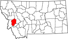 | |
| CDP | ||
| Unincorporated community | ||
| Ghost towns | ||
This article is issued from Wikipedia - version of the 8/8/2016. The text is available under the Creative Commons Attribution/Share Alike but additional terms may apply for the media files.