Mason and Dixon Survey Terminal Point
|
Mason and Dixon Survey Terminal Point | |
 | |
  | |
| Location | 2.25 mi (3.62 km) northeast of Pentress on County Route 39, near Pentress, West Virginia |
|---|---|
| Coordinates | 39°43′16″N 80°7′7″W / 39.72111°N 80.11861°WCoordinates: 39°43′16″N 80°7′7″W / 39.72111°N 80.11861°W |
| Area | 0 acres (0 ha) |
| Built | 1883 |
| NRHP Reference # | 73001922[1] |
| Added to NRHP | June 25, 1973 |
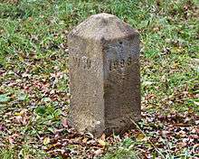
Mason and Dixon Survey Terminal Point is a historic marker located near Pentress, West Virginia, United States. Located on the boundary between Monongalia County, West Virginia and Greene County, Pennsylvania,[1] it identifies the terminal station established by Charles Mason and Jeremiah Dixon on Brown's Hill on October 19, 1767. The stone placed on Brown's Hill in 1883 in the mound of 1767, marks the westernmost point reached by Mason and Dixon in delineating the common boundaries of Pennsylvania, Maryland, Delaware, and Virginia (now West Virginia), and known as the Mason–Dixon line.[2]
It was listed on the National Register of Historic Places in 1973.[1]
West Virginia Marker Face
See also
References
- 1 2 3 National Park Service (2010-07-09). "National Register Information System". National Register of Historic Places. National Park Service.
- ↑ E.L. Kemp (September 1972). "National Register of Historic Places Inventory Nomination Form: Mason and Dixon Survey Terminal Point" (PDF). State of West Virginia, West Virginia Division of Culture and History, Historic Preservation. Retrieved 2011-08-20.
| Topics |  | |
|---|---|---|
| Lists by county |
| |
| Other lists | ||
| ||
This article is issued from Wikipedia - version of the 11/28/2016. The text is available under the Creative Commons Attribution/Share Alike but additional terms may apply for the media files.