Maryland Route 781
| ||||
|---|---|---|---|---|
| Delancy Road | ||||
 | ||||
| Route information | ||||
| Maintained by MDSHA | ||||
| Length: | 1.01 mi[1] (1.63 km) | |||
| Existed: | 1984 – present | |||
| Major junctions | ||||
| South end: |
| |||
| North end: |
| |||
| Location | ||||
| Counties: | Cecil | |||
| Highway system | ||||
| ||||

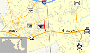
Maryland Route 781 (MD 781) is a state highway in the U.S. state of Maryland. Known as Delancy Road, the state highway runs 1.01 miles (1.63 km) from U.S. Route 40 (US 40) north to MD 281 in Elkton close to the Delaware state line. Delancy Road was brought into the state highway system as MD 781 in 1984.
Route description
MD 781 begins at an intersection with US 40 (Pulaski Highway) in the town of Elkton 0.23 miles (0.37 km) west of the U.S. Highway's crossing of the Delaware state line. The highway heads north as a two-lane road to the west of the state line and to the east of Grays Hill. MD 781 leaves the town of Elkton about halfway through its course, but the route follows a finger of unincorporated area between sections of the town to its northern terminus. That terminus is at MD 281 (Red Hill Road) 0.34 miles (0.55 km) west of that highway's crossing of the state line.[1][2]
History
Delancy Road long predates being a part of the state highway system, the road having existed since at least 1898.[3] The highway was designated MD 781 in December 1984 after being transferred from county to state maintenance in a May 16, 1984, road transfer agreement.[4][5]
Junction list
The entire route is in Elkton, Cecil County.
| mi[1] | km | Destinations | Notes | ||
|---|---|---|---|---|---|
| 0.00 | 0.00 | ||||
| 1.01 | 1.63 | ||||
| 1.000 mi = 1.609 km; 1.000 km = 0.621 mi | |||||
See also
 Maryland Roads portal
References
- 1 2 3 Highway Information Services Division (December 31, 2014). Highway Location Reference. Maryland State Highway Administration. Retrieved July 13, 2016.
- Cecil County (PDF)
- ↑ Maryland State Highway Administration (2015). Maryland General Highway Statewide Grid Map (PDF) (Map). 1:12,000. Baltimore: Maryland State Highway Administration. §§ A16C, B16A. Retrieved July 13, 2016.
- ↑ Elkton, MD quadrangle (Map) (1898 ed.). 1:48,000. 15 Minute Series (Topographic). United States Geological Survey.
- ↑ "Memorandum of Action of Director Neil J. Pedersen" (PDF). S.R.C. Minutes District No. 2 Cecil County. Baltimore: Maryland State Highway Administration. December 11, 1984. Retrieved July 13, 2016 – via Maryland State Archives.
- ↑ "Memorandum of Action of Acting Director Neil Pedersen" (PDF). S.R.C. Minutes District No. 2 Cecil County. Baltimore: Maryland State Highway Administration. June 11, 1984. Retrieved July 13, 2016 – via Maryland State Archives.