List of Interstate Highways in Maryland
| Interstate Highways of the Maryland highway system | |
|---|---|
|
Standard route signs in Maryland | |
 | |
| Highway names | |
| Interstates: | Interstate X (I-X) |
| System links | |


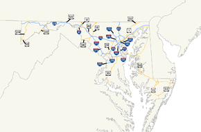
The following is a list of Interstate Highways in Maryland. There are currently 16 Interstate Highways that exist entirely or partially in the U.S. state of Maryland. Six of these are primary Interstates while ten are auxiliary Interstates related to one of the primary Interstates. The longest primary Interstate in Maryland is Interstate 95 (commonly abbreviated I-95) at 110.01 mi (177.04 km). The shortest primary Interstate in Maryland is I-81 at 12.08 mi (19.44 km). I-97 is the shortest primary Interstate at 17.62 mi (28.36 km) and the shortest intrastate Interstate. I-97 is also the only primary Interstate to be located entirely within one county and to not connect with any other primary Interstate. The longest auxiliary Interstate in Maryland is I-695 at 51.48 mi (82.85 km). The shortest auxiliary Interstate in Maryland is I-295 at 0.80 mi (1.29 km). All Interstates are maintained by the Maryland State Highway Administration except for all of I-395, all of I-895, a small part of I-695, I-95 within and north of Baltimore, and I-83 within Baltimore. Maryland has one unsigned Interstate, I-595; that highway is marked as U.S. Route 50 and US 301, which are concurrent with I-595 for its entire length. Maryland has one former Interstate, I-170, which is shaded in dark gray in the list.
| Number | Length (mi)[1] | Length (km) | Southern or western terminus | Northern or eastern terminus | Formed | Removed | Notes |
|---|---|---|---|---|---|---|---|
| 81.09 | 130.50 | I-68 at the West Virginia state line near Friendsville | I-70 / US 40 / US 522 in Hancock | 1991[2] | current | ||
| 93.62 | 150.67 | I-70 / US 522 at the Pennsylvania state line in Hancock | MD 122 / Park and ride in Baltimore | 1962[3] | current | Frederick–Baltimore section was designated I-70N in 1965;[4] that section became part of I-70 in 1974[5] | |
| 12.08 | 19.44 | I-81 at the West Virginia state line in Williamsport | I-81 at the Pennsylvania state line near Hagerstown | 1959[6] | current | ||
| 34.50 | 55.52 | Fayette Street and President Street in Baltimore | I-83 at the Pennsylvania state line at Maryland Line | 1959[6] | current | ||
| 110.01 | 177.04 | I-95 / I-495 at the Virginia state line near Oxon Hill | I-95 at the Delaware state line near Elkton | 1963[7] | current | ||
| 17.62 | 28.36 | US 50 / US 301 in Parole | I-695 / I-895 in Ferndale | 1987[8] | current | ||
| 1.40 | 2.25 | US 1 / US 40 in Baltimore | US 40 in Baltimore | 1981[9] | 1985[10] | Replaced by US 40 | |
| 4.35 | 7.00 | I-95 / MD 166 in Arbutus | MD 170 near BWI Airport | 1989[11] | current | ||
| 32.60 | 52.46 | I-495 / MD 355 in Bethesda | I-70 / US 40 in Frederick | 1959[6] | current | Designated I-70S in 1959; became I-270 in 1974[5] | |
| 0.80 | 1.29 | I-95 / I-495 / MD 210 in Oxon Hill | I-295 in Washington, D.C. | 1965[4] | current | ||
| 2.54 | 4.09 | Sam Eig Highway in Gaithersburg | MD 200 in Redland | 1989[11] | current | ||
| 1.33 | 2.14 | I-95 in Baltimore | Howard Street and Camden Street in Baltimore | 1981[9] | current | ||
| 41.09 | 66.13 | I-95 / I-495 at the Virginia state line near Oxon Hill | I-495 at the Virginia state line near Cabin John | 1963[7] | current | Beltway around Washington, D.C. | |
| 19.97 | 32.14 | I-95 / I-495 / US 50 near Glenarden | US 50 / US 301 / MD 70 in Parole | 1991 | current | Unsigned highway; signed as US 50 and US 301 | |
| 51.46 | 82.82 | Beltway around Baltimore | 1959[6] | current | |||
| 8.99 | 14.47 | I-695 in Pikesville | MD 140 / MD 795 in Reisterstown | 1985[10] | current | ||
| 14.87 | 23.93 | I-95 in Elkridge | I-95 in Baltimore | 1979[12] | current | ||
See also
 Maryland Roads portal
References
- ↑ Highway Information Services Division (December 31, 2013). Highway Location Reference. Maryland State Highway Administration. Retrieved 2012-10-06.
- ↑ Maryland State Highway Administration (1991). Maryland: Official Highway Map (Map). Baltimore: Maryland State Highway Administration.
- ↑ Maryland State Roads Commission (1962). Maryland: Official Highway Map (Map). Baltimore: Maryland State Roads Commission.
- 1 2 Maryland State Roads Commission (1965). Maryland: Official Highway Map (Map). Baltimore: Maryland State Roads Commission.
- 1 2 Maryland State Highway Administration (1974). Maryland: Official Highway Map (Map). Baltimore: Maryland State Highway Administration.
- 1 2 3 4 Maryland State Roads Commission (1959). Maryland: Official Highway Map (Map). Baltimore: Maryland State Roads Commission.
- 1 2 Maryland State Roads Commission (1963). Maryland: Official Highway Map (Map). Baltimore: Maryland State Roads Commission.
- ↑ Maryland State Highway Administration (1987). Maryland: Official Highway Map (Map). Baltimore: Maryland State Highway Administration.
- 1 2 Maryland State Highway Administration (1981). Maryland: Official Highway Map (Map) (1981–82 ed.). Baltimore: Maryland State Highway Administration.
- 1 2 Maryland State Highway Administration (1985). Maryland: Official Highway Map (Map) (1985–86 ed.). Baltimore: Maryland State Highway Administration.
- 1 2 Maryland State Highway Administration (1989). Maryland: Official Highway Map (Map). Baltimore: Maryland State Highway Administration.
- ↑ Maryland State Highway Administration (1979). Maryland: Official Highway Map (Map) (1979–80 ed.). Baltimore: Maryland State Highway Administration.
| Lists of highways | ||
|---|---|---|
| Shorter than 1 mile (1.6 km) | ||
| Former state highways | ||
| Highway agencies | ||
| Other articles | ||