Maryland Route 755
| ||||
|---|---|---|---|---|
| Edgewood Road | ||||
 | ||||
| Route information | ||||
| Maintained by MDSHA | ||||
| Length: | 1.79 mi[1] (2.88 km) | |||
| Existed: | 1970 – present | |||
| Major junctions | ||||
| South end: | Entrance to Aberdeen Proving Ground | |||
|
| ||||
| North end: |
| |||
| Location | ||||
| Counties: | Harford | |||
| Highway system | ||||
| ||||

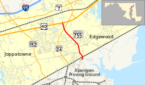
Maryland Route 755 (MD 755) is a state highway in the U.S. state of Maryland. Known as Edgewood Road, the state highway runs 1.79 mi (2.88 km) from an entrance to Aberdeen Proving Ground north to U.S. Route 40 (US 40) in Edgewood. Originally constructed as MD 408 in 1930, the state highway became a southern extension of MD 24 in the early 1950s. MD 755 was designated in the early 1970s after MD 24 moved to its present course.
Route description
_just_north_of_Willoughby_Beach_Road_in_Edgewood%2C_Harford_County%2C_Maryland.jpg)
MD 755 begins at an entrance to the Edgewood Area of Aberdeen Proving Ground. The state highway heads north as a two-lane road that passes under the Amtrak Northeast Corridor and passes by two entrances to the Edgewood MARC station, which is a stop on MARC's Penn Line. After leaving the village of Edgewood and passing Trimble Road, MD 755 expands to a three-lane road with center turn lane. The state highway continues north through residential subdivisions until an acute intersection with MD 24 (Emmorton Road). Beyond that intersection, MD 755 expands to a four-lane undivided highway and enters a commercial area before reaching its northern terminus at US 40 (Pulaski Highway). Edgewood Road continues north as a two-lane county highway that crosses Winters Run, has a one-lane underpass of CSX's Philadelphia Subdivision, and intersects MD 7 before veering northeast to another intersection with MD 24 just south of Interstate 95 (I-95).[1][2]
MD 755 is a part of the National Highway System as an intermodal connector between the Edgewood MARC station and MD 24.[1][3]
History
Edgewood Road was built as a concrete road from US 40 (now MD 7) in the community of Van Bibber south to its entrance to Aberdeen Proving Ground at its Pennsylvania Railroad crossing (now Amtrak) in 1930.[4] The state highway, which was originally designated MD 408, was constructed with a width of 16 feet (4.9 m) but was proposed for widening to 20 feet (6.1 m) as early as 1934 since it was the main entrance to the Edgewood Arsenal.[5] MD 408 received an underpass of the Baltimore & Ohio Railroad (now CSX) and approaches to the grade separation in 1939.[6] MD 24 assumed all of MD 408 when MD 24 was extended south from MD 7 to Aberdeen Proving Ground in 1952.[7] A new section of Edgewood Road was constructed from MD 7 north to just south of the future I-95 interchange in 1956 to remove MD 24's staggered intersections at MD 7 in Van Bibber.[8]
The next relocation of MD 24 in the Edgewood area occurred in two sections starting in 1967.[9] MD 24 was moved to its present alignment from just south of the I-95 interchange to Edgewood Road south of US 40 in 1970.[10] The bypass included a bridge over US 40; access between the two highways was provided by Edgewood Road, which was designated MD 755. The new alignment of MD 24 was extended south to a new entrance to Aberdeen Proving Ground in 1974; MD 755 was extended south along MD 24's old alignment to the pre-existing entrance next to the Edgewood train station.[11] MD 755 achieved its present length around 1991 when the portion of Edgewood Road north of US 40 was transferred to county maintenance.[12]
Junction list
The entire route is in Edgewood, Harford County.
| mi[1] | km | Destinations | Notes | ||
|---|---|---|---|---|---|
| 0.00 | 0.00 | Entrance to Aberdeen Proving Ground | Southern terminus | ||
| 1.56 | 2.51 | ||||
| 1.79 | 2.88 | Northern terminus | |||
| 1.000 mi = 1.609 km; 1.000 km = 0.621 mi | |||||
See also
 Maryland Roads portal
References
- 1 2 3 4 Highway Information Services Division (December 31, 2013). Highway Location Reference. Maryland State Highway Administration. Retrieved 2011-02-27.
- Harford County (PDF)
- ↑ Google (2010-08-03). "Maryland Route 755" (Map). Google Maps. Google. Retrieved 2010-08-03.
- ↑ National Highway System: Aberdeen, MD (PDF) (Map). Federal Highway Administration. October 1, 2012. Retrieved 2015-05-15.
- ↑ Maryland Geological Survey (1930). Map of Maryland Showing State Road System: State Aid Roads and Improved County Road Connections (Map). Baltimore: Maryland Geological Survey.
- ↑ Byron, William D.; Lacy, Robert (December 28, 1934). Report of the State Roads Commission of Maryland (1931–1934 ed.). Baltimore: Maryland State Roads Commission. p. 22. Retrieved 2011-02-27.
- ↑ Whitman, Ezra B.; Webb, P. Watson; Thomas, W. Frank (March 15, 1941). Report of the State Roads Commission of Maryland (1939–1940 ed.). Baltimore: Maryland State Roads Commission. p. 104. Retrieved 2011-02-27.
- ↑ Maryland State Roads Commission (1952). Maryland: Official Highway Map (Map). Baltimore: Maryland State Roads Commission.
- ↑ Maryland State Roads Commission (1956). Maryland: Official Highway Map (Map). Baltimore: Maryland State Roads Commission.
- ↑ Federal Highway Administration (2012). "NBI Structure Number: 100000120062012". National Bridge Inventory. Federal Highway Administration.
- ↑ Maryland State Roads Commission (1970). Maryland: Official Highway Map (Map). Baltimore: Maryland State Roads Commission.
- ↑ Maryland State Highway Administration (1974). Maryland: Official Highway Map (Map). Baltimore: Maryland State Highway Administration.
- ↑ Maryland State Highway Administration (1991). Maryland: Official Highway Map (Map). Baltimore: Maryland State Highway Administration.