Maryland Route 137
| ||||
|---|---|---|---|---|
| Mount Carmel Road | ||||
|
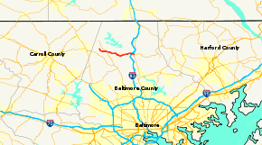
Maryland Route 137 highlighted in red | ||||
| Route information | ||||
| Maintained by MDSHA | ||||
| Length: | 8.50 mi[1] (13.68 km) | |||
| Existed: | 1927 – present | |||
| Tourist routes: |
| |||
| Major junctions | ||||
| West end: | Gunpowder Road near Hampstead | |||
|
| ||||
| East end: |
| |||
| Location | ||||
| Counties: | Baltimore | |||
| Highway system | ||||
| ||||

Maryland Route 137 (MD 137) is a state highway in the U.S. state of Maryland. Known as Mount Carmel Road, the state highway runs 8.50 miles (13.68 km) from Gunpowder Road near Hampstead east to MD 45 at Hereford in northern Baltimore County. MD 137 was built in the early 1920s.
Route description
MD 137 begins at a three-way intersection with Gunpowder Road, which heads east toward Prettyboy Reservoir, and a county-maintained continuation of Mount Carmel Road west toward Hampstead. Mount Carmel Road becomes Lower Beckleysville Road on entering Carroll County and intersects MD 88 (Black Rock Road). MD 137 heads south and curves east and intersects MD 25 (Falls Road). The state highway continues east through farmland along the drainage divide between Gunpowder Falls to the north and its tributary Western Run to the south and passes its namesake church, now named Mount Carmel United Methodist Church. MD 137 meets Interstate 83 (I-83) (Harrisburg Expressway) at a diamond interchange with ramps staggered into four intersections. Opposite the easternmost ramp, which is from northbound I-83 to MD 137, is unsigned MD 889, the access road to the Maryland State Highway Administration's Hereford Shop. East of I-83, MD 137 reaches its eastern terminus at a three-way intersection with MD 45 (York Road) 0.10-mile (0.16 km) north of the western terminus of MD 138 (Monkton Road).[1][2]
History
MD 137 was paved as a concrete road from its western terminus to Falls Road and from near the Mount Carmel church to York Road by 1921.[3] The intervening segment between Falls Road and the church was completed in 1923.[4] Outside of the construction of its interchange with I-83 between 1954 and 1956, MD 137 has changed very little since it was built.[5]
Junction list
The entire route is in Baltimore County.
| Location | mi [1] | km | Destinations | Notes | |
|---|---|---|---|---|---|
| | 0.00 | 0.00 | Gunpowder Road east / Mount Carmel Road west – Hampstead | Western terminus | |
| | 1.87 | 3.01 | |||
| Hereford | 7.94 | 12.78 | I-83 Exit 27 | ||
| 8.50 | 13.68 | Eastern terminus | |||
| 1.000 mi = 1.609 km; 1.000 km = 0.621 mi | |||||
See also
 Maryland Roads portal
References
- 1 2 3 Highway Information Services Division (December 31, 2013). Highway Location Reference. Maryland State Highway Administration. Retrieved 2002-02-16.
- Baltimore County (PDF)
- ↑ Google (2012-02-16). "Maryland Route 137" (Map). Google Maps. Google. Retrieved 2012-02-16.
- ↑ Maryland Geological Survey (1921). Map of Maryland: Showing State Road System and State Aid Roads (Map). Baltimore: Maryland Geological Survey.
- ↑ Maryland Geological Survey (1923). Map of Maryland: Showing State Road System and State Aid Roads (Map). Baltimore: Maryland Geological Survey.
- ↑ Bonnell, Robert O.; Bennett, Edgar T.; McMullen, John J. (November 2, 1956). Report of the State Roads Commission of Maryland (1955–1956 ed.). Baltimore: Maryland State Roads Commission. p. 162. Retrieved 2012-02-16.