Maryland Route 131
| ||||
|---|---|---|---|---|
| Seminary Avenue | ||||
|
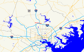
Maryland Route 131 highlighted in red | ||||
| Route information | ||||
| Maintained by MDSHA | ||||
| Length: | 3.06 mi[1] (4.92 km) | |||
| Existed: | 1927 – present | |||
| Major junctions | ||||
| West end: |
| |||
| East end: |
| |||
| Location | ||||
| Counties: | Baltimore | |||
| Highway system | ||||
| ||||

Maryland Route 131 (MD 131) is a state highway in the U.S. state of Maryland. Known as Seminary Avenue, the state highway runs 3.06 miles (4.92 km) from MD 25 in Brooklandville east to MD 45 in Lutherville. MD 131 was mostly constructed by 1910, with the remainder completed in the early 1920s.
Route description
MD 131 begins at a four-way intersection with MD 25 (Falls Road) in Brooklandville. The west leg of the intersection is the entrance to St. Paul's School. MD 131 heads east as a two-lane road through the southern end of the suburban community of Mays Chapel. The state highway crosses over Interstate 83 (I-83) (Harrisburg Expressway) with no access and enters Lutherville, where the road has an at-grade intersection with the Baltimore Light Rail. MD 131 continues through the Lutherville Historic District and intersects Bellona Road before reaching its eastern terminus at MD 45 (York Road). Seminary Avenue continues east as a county highway that intersects MD 146 (Dulaney Valley Road) and passes through Hampton before ending at Providence Road.[1][2]
History
Seminary Avenue was paved from Brooklandville east to the rail crossing—then part of the Northern Central Railway—by 1910.[3] The remainder of the highway was paved by 1923.[4] Aside from the construction of the I-83 overpass around 1956, there has been very little change to MD 131 since then.[5]
Junction list
The entire route is in Baltimore County.
| Location | mi [1] | km | Destinations | Notes | |
|---|---|---|---|---|---|
| Brooklandville | 0.00 | 0.00 | Western terminus | ||
| Lutherville | 3.06 | 4.92 | Eastern terminus | ||
| 1.000 mi = 1.609 km; 1.000 km = 0.621 mi | |||||
See also
 Maryland Roads portal
References
- 1 2 3 Highway Information Services Division (December 31, 2013). Highway Location Reference. Maryland State Highway Administration. Retrieved 2012-02-10.
- Baltimore County (PDF)
- ↑ Google (2012-02-10). "Maryland Route 131" (Map). Google Maps. Google. Retrieved 2012-02-10.
- ↑ Maryland Geological Survey (1910). Map of Maryland (Map). Baltimore: Maryland Geological Survey.
- ↑ Maryland Geological Survey (1923). Map of Maryland: Showing State Road System and State Aid Roads (Map). Baltimore: Maryland Geological Survey.
- ↑ Bonnell, Robert O.; Bennett, Edgar T.; McMullen, John J. (November 2, 1956). Report of the State Roads Commission of Maryland (1955–1956 ed.). Baltimore: Maryland State Roads Commission. p. 4. Retrieved 2012-02-10.