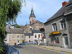
Couvin
| Couvin | ||
|---|---|---|
| Municipality | ||
 | ||
| ||
 Couvin Location in Belgium | ||
|
Location of Couvin in the province of Namur 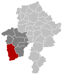 | ||
| Coordinates: 50°03′N 04°29′E / 50.050°N 4.483°ECoordinates: 50°03′N 04°29′E / 50.050°N 4.483°E | ||
| Country | Belgium | |
| Community | French Community | |
| Region | Wallonia | |
| Province | Namur | |
| Arrondissement | Philippeville | |
| Government | ||
| • Mayor | Raymond Douniaux (PS) | |
| • Governing party/ies | PS, MR, IC | |
| Area | ||
| • Total | 206.93 km2 (79.90 sq mi) | |
| Population (1 January 2016)[1] | ||
| • Total | 13,946 | |
| • Density | 67/km2 (170/sq mi) | |
| Postal codes | 5660 | |
| Area codes | 060 | |
| Website | www.couvin.be | |
.svg.png)
Couvin (French pronunciation: [ku.vɛ̃]) is a Belgian town located in the province of Namur.
On 1 January 2006 the municipality had 13,476 inhabitants. Couvin is the second largest municipality of Belgium by surface area, after Tournai. The total area is 206.93 km², giving a population density of 65 inhabitants per km².
The municipality consists of the following sub-municipalities: Couvin proper, Aublain, Boussu-en-Fagne, Brûly, Brûly-de-Pesche, Cul-des-Sarts, Dailly, Frasnes-lez-Couvin, Gonrieux, Mariembourg, Pesche, Petigny, Petite-Chapelle, and Presgaux.
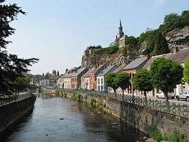
River Eau Noire and the Rue de la Falaise
Transport
Couvin railway station provides the town with a rail link direct to Charleroi. The line terminates here; the next station is Mariembourg.
See also
References
- ↑ Population per municipality as of 1 January 2016 (XLS; 397 KB)
External links
-
 Media related to Couvin at Wikimedia Commons
 - Official website
 |
Froidchapelle (WHT) | Cerfontaine | Philippeville | |
| Chimay (WHT) | |
Viroinval | ||
| ||||
| | ||||
| Regniowez (FR-08) | Taillette, Gué-d'Hossus, Rocroi (all FR-08) | Fumay (FR-08) |
Municipalities in the Province of Namur | ||
|---|---|---|
| Dinant |  | |
| Namur | ||
| Philippeville | ||
This article is issued from Wikipedia - version of the 12/1/2016. The text is available under the Creative Commons Attribution/Share Alike but additional terms may apply for the media files.