Maher, Colorado
| Maher, Colorado | |
|---|---|
| Unincorporated community | |
|
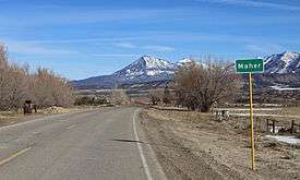
Maher in 2016, with Mount Lamborn in the distance. | |
  Location in the state of Colorado | |
| Coordinates: 38°38′46″N 107°35′07″W / 38.64611°N 107.58528°WCoordinates: 38°38′46″N 107°35′07″W / 38.64611°N 107.58528°W | |
| Country |
|
| State |
|
| Counties | Montrose[1] |
| Elevation[1] | 6,808 ft (2,075 m) |
| Time zone | MST (UTC-7) |
| • Summer (DST) | MDT (UTC-6) |
| ZIP code[2] | 81415 (Crawford) |
| Area code(s) | 970 |
| GNIS feature ID | 0186732 |
Maher is an unincorporated community located in Montrose County,[1] Colorado, United States. The U.S. Post Office at Crawford (ZIP Code 81415) now serves Maher postal addresses.[2]
Geography
Maher is located at 38°38′46″N 107°35′07″W / 38.64611°N 107.58528°W (38.646104,-107.585163).
References
- 1 2 3 "US Board on Geographic Names". United States Geological Survey. 2007-10-25. Retrieved 2008-01-31.
- 1 2 "ZIP Code Lookup" (JavaScript/HTML). United States Postal Service. January 3, 2007. Retrieved January 3, 2007.
Municipalities and communities of Montrose County, Colorado, United States | ||
|---|---|---|
| City | 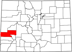 | |
| Towns | ||
| CDP | ||
| Unincorporated communities | ||
| Ghost town | ||
This article is issued from Wikipedia - version of the 7/31/2016. The text is available under the Creative Commons Attribution/Share Alike but additional terms may apply for the media files.