Magra, Algeria
| Magra | |
|---|---|
| Commune and town | |
 | |
 | |
| Country |
|
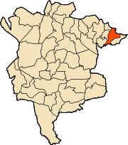
| Province | M'Sila Province |
| Area | |
| • Land | 25.573 sq mi (66.234 km2) |
| Population (2008) | |
| • Total | 39,250 |
| Time zone | CET (UTC+1) |
| Code Postal | 28150 |
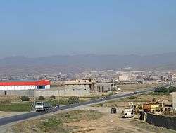
Magra is a town and commune in M'Sila Province, Algeria. According to the 1998 census it has a population of 31,749.[1]
Municipal establishment and location
City: Magra Country: Algeria Latitude: 35.69208 Longitude: 5.1074 Time Zone: UTC+1, Africa/Algiers [2]
Municipality Magra established in: 01.01.1957 after separated from the mixed state of the Aures former municipality, and in 1974 became an administrative and a regional to the state of M'sila, is located in the north-east of the state, mediated by the territorial boundaries of the states. "Batna, Setif," and the meeting of national roads, "28 and 40 ". Run by popular elected municipal council consists of 11 members with different municipal administration political composition of 28 permanent employees, and operates 143 workers, including 38 temporary distributors on various municipal facilities.
History
Is the village of Zab which is called in Magra, is located between city of Barika and M'sila. was first mentioned by Muslim traveler Elyacoubi, who died in 284 AH (827 AD), where he said, "and the city said to be Magra, have many forts, its people are, some of the Bani Debba and some of Ajam they are told Trirh, around them some of the Berbers called the children of Negroes.", as said by Yakot Elhamwi "Magra is a city in Maghrib, close to the castle Bani Hammad between Tabna eight farsakhs, by armed Sultan road officer, attributed to" Abdul Rahman bin Mohammed Mokri. "And Idrissi said" Magra is great city, where the Tribune and Walls its people of Bani Debba by some of the Ajam and around some of the Berbers, the farms and many forts, people are planting flax, and in the near age was famous for rich gardens, and its farmland fertile, was famous for the production of olive oil, until it became the proverbial that "a shaggy head ... oh so come to you oil from Magra" .and it has several sites known as "Hncher Remada, dating back to the Roman era, where rich natural areas, to become after the Islamic conquests big city.
Topography and location
Municipality is located in the north-eastern side of the Shatt al-Hodna basin, surrounded by Magra network and Bouchaara that belong to the mountain range known as the "Hodna Heights" with an altitude of 800 to 1000 m. Affected by a Mediterranean climate semi-continental climate, hot dry summers, cool rainy winter, a height above sea level of about 600 m. Monthly rainfall up to a maximum ratio between the months of November and March In up to 50% of the total rainfall. Temperature according to studies presented by the International Organization for feeding that took place on the shore of Hodna area, the monthly rate up to 18.6 degrees and the average annual rainfall 415 mm.
References
- ↑ Statoids
- ↑ "Latitude and Longitude". Satsig.net. Retrieved 13 September 2013.
Capital: M'Sila | ||
| Districts |
|  |
| Communes |
| |
Coordinates: 35°36′N 5°04′E / 35.600°N 5.067°E