Magnolia, Kentucky
| Magnolia | |
|---|---|
| Census-designated place (CDP) | |
 Magnolia | |
| Coordinates: 37°26′38″N 85°44′37″W / 37.44389°N 85.74361°WCoordinates: 37°26′38″N 85°44′37″W / 37.44389°N 85.74361°W | |
| Country | United States |
| State | Kentucky |
| County | LaRue |
| Area[1] | |
| • Total | 2.047 sq mi (5.30 km2) |
| • Land | 2.039 sq mi (5.28 km2) |
| • Water | 0.008 sq mi (0.02 km2) |
| Elevation | 860 ft (260 m) |
| Population (2010)[2] | |
| • Total | 524 |
| • Density | 260/sq mi (99/km2) |
| Time zone | Eastern (EST) (UTC-5) |
| • Summer (DST) | EDT (UTC-4) |
| Area code(s) | 270 |
| GNIS feature ID | 497453[3] |
Magnolia is a census-designated place and unincorporated community in LaRue County, Kentucky, United States. Its population was 524 as of the 2010 census.[2] The Magnolia area was settled in the 1780s primarily by Virginians seeking land following the American Revolution.
References
- ↑ "US Gazetteer files: 2010, 2000, and 1990". United States Census Bureau. 2011-02-12. Retrieved 2011-04-23.
- 1 2 "American FactFinder". United States Census Bureau. Retrieved 2011-05-14.
- ↑ "Magnolia". Geographic Names Information System. United States Geological Survey.
Municipalities and communities of LaRue County, Kentucky, United States | ||
|---|---|---|
| Cities | 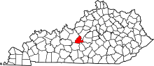 | |
| CDPs | ||
| Other unincorporated communities |
| |
| Footnotes | ‡This populated place also has portions in an adjacent county or counties | |
This article is issued from Wikipedia - version of the 9/29/2014. The text is available under the Creative Commons Attribution/Share Alike but additional terms may apply for the media files.