Low Pass, Oregon
| Low Pass | |
|---|---|
| Unincorporated community | |
 | |
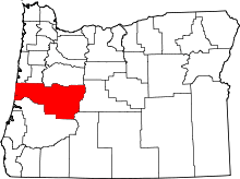
 Low Pass  Low Pass Location within the state of Oregon | |
| Coordinates: 44°11′19″N 123°27′14″W / 44.18861°N 123.45389°WCoordinates: 44°11′19″N 123°27′14″W / 44.18861°N 123.45389°W | |
| Country | United States |
| State | Oregon |
| County | Lane |
| Time zone | Pacific (PST) (UTC-8) |
| • Summer (DST) | PDT (UTC-7) |
| ZIP code | 97419 |
| Area code(s) | 458 and 541 |
| GNIS feature ID | 1136499 |
Low Pass is an unincorporated community in Lane County, Oregon, United States, on the Long Tom River, 5 miles (8 km) east of Blachly and 11 miles (18 km) west of Cheshire.
The settlement is centered on a small pullout on Oregon Route 36 with a gas station/convenience store and a diner that serves as an unofficial community center for rural residents.[1][2]
The nearest recycling & waste facility is the Low Pass Transfer Station[3][4]
The settlement is named for its location on a slight rise approaching the foothills of the Coast Range mountains, in contrast to the nearby mountain pass High Pass.[5] Much of the land west of Low Pass consists of old-growth forest owned by the Bureau of Land Management.[6][7]
The community has also been known as "Long Tom Station" after the nearby river; the name Low Pass was made official by a United States Board on Geographic Names decision of 1985.[8]
References
- ↑ McCowan, Karen (February 4, 2004). "Eat and Greet, Over Easy: A roadside cafe doubles as a community center in Low Pass". The Register-Guard.
- ↑ Welch, Bob (November 21, 2006). "For a high time in Low Pass, Eat at Joe's". The Register-Guard. Retrieved April 1, 2008.
- ↑ "site details: Low Pass [Lane County Disposal Site]". www.lanecounty.org. Retrieved 2016-07-01.
- ↑ "Waste Disposal & Recycling Sites (google map of Lane County disposal sites - scroll down on webpage)". www.lanecounty.org. Retrieved 2016-07-01.
- ↑ "Feature Query Results". United States Board on Geographic Names, United States Geological Survey. Retrieved April 1, 2008.
- ↑ Bureau of Land Management. "Detailed Map of Eugene District". About Eugene. Retrieved April 1, 2008.
- ↑ Oregon Wild. "Low Pass old-growth, Eugene BLM". Retrieved April 1, 2008.
- ↑ "Low Pass". Geographic Names Information System. United States Geological Survey. May 22, 1986. Retrieved December 24, 2009.