Low Gap, West Virginia
| Low Gap | |
|---|---|
| Unincorporated community | |
 Low Gap  Low Gap Location within the state of West Virginia | |
| Coordinates: 38°1′53″N 81°50′8″W / 38.03139°N 81.83556°WCoordinates: 38°1′53″N 81°50′8″W / 38.03139°N 81.83556°W | |
| Country | United States |
| State | West Virginia |
| County | Boone |
| Elevation | 745 ft (227 m) |
| Time zone | Eastern (EST) (UTC-5) |
| • Summer (DST) | EDT (UTC-4) |
| GNIS ID | 1542497[1] |
Low Gap is an unincorporated community in Boone County, West Virginia.
The community was named for a low mountain pass near the original town site.[2]
References
- ↑ U.S. Geological Survey Geographic Names Information System: Low Gap, West Virginia
- ↑ Kenny, Hamill (1945). West Virginia Place Names: Their Origin and Meaning, Including the Nomenclature of the Streams and Mountains. Piedmont, WV: The Place Name Press. p. 389.
Municipalities and communities of Boone County, West Virginia, United States | ||
|---|---|---|
| City | 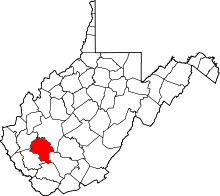 | |
| Towns | ||
| CDPs | ||
| Unincorporated communities |
| |
| Footnotes | ‡This populated place also has portions in an adjacent county or counties | |
This article is issued from Wikipedia - version of the 7/28/2016. The text is available under the Creative Commons Attribution/Share Alike but additional terms may apply for the media files.