Lone Star, Texas
| Lone Star, Texas | |
|---|---|
| City | |
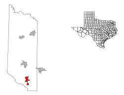
 Location of Lone Star, Texas | |
 | |
| Coordinates: 32°56′35″N 94°42′29″W / 32.94306°N 94.70806°WCoordinates: 32°56′35″N 94°42′29″W / 32.94306°N 94.70806°W | |
| Country | United States |
| State | Texas |
| County | Morris |
| Area | |
| • Total | 2.0 sq mi (5.2 km2) |
| • Land | 2.0 sq mi (5.1 km2) |
| • Water | 0.0 sq mi (0.0 km2) |
| Elevation | 348 ft (106 m) |
| Population (2000) | |
| • Total | 1,631 |
| • Density | 820.6/sq mi (316.8/km2) |
| Time zone | Central (CST) (UTC-6) |
| • Summer (DST) | CDT (UTC-5) |
| ZIP code | 75668 |
| Area code(s) | 903 |
| FIPS code | 48-43684[1] |
| GNIS feature ID | 1340390[2] |
Lone Star is a city in Morris County, Texas, United States. The population was 1,581 at the 2010 census.
Geography
Lone Star is located at 32°56′35″N 94°42′29″W / 32.94306°N 94.70806°W (32.943105, -94.708017).[3]
According to the United States Census Bureau, the city has a total area of 2.0 square miles (5.2 km2), of which, 2.0 square miles (5.2 km2) of it is land and 0.50% is water.
Demographics
| Historical population | |||
|---|---|---|---|
| Census | Pop. | %± | |
| 1960 | 1,513 | — | |
| 1970 | 1,760 | 16.3% | |
| 1980 | 2,036 | 15.7% | |
| 1990 | 1,615 | −20.7% | |
| 2000 | 1,631 | 1.0% | |
| 2010 | 1,581 | −3.1% | |
| Est. 2015 | 1,525 | [4] | −3.5% |
As of the census[1] of 2000, there were 1,631 people, 665 households, and 468 families residing in the city. The population density was 820.6 people per square mile (316.4/km²). There were 776 housing units at an average density of 390.4 per square mile (150.6/km²). The racial makeup of the city was 73.88% White, 19.87% African American, 0.43% Native American, 0.31% Asian, 3.62% from other races, and 1.90% from two or more races. Hispanic or Latino of any race were 6.44% of the population.
There were 665 households out of which 30.7% had children under the age of 18 living with them, 46.8% were married couples living together, 18.2% had a female householder with no husband present, and 29.6% were non-families. 26.3% of all households were made up of individuals and 13.7% had someone living alone who was 65 years of age or older. The average household size was 2.45 and the average family size was 2.92.
In the city the population was spread out with 27.2% under the age of 18, 8.3% from 18 to 24, 24.4% from 25 to 44, 24.3% from 45 to 64, and 15.7% who were 65 years of age or older. The median age was 36 years. For every 100 females there were 85.6 males. For every 100 females age 18 and over, there were 83.2 males.
The median income for a household in the city was $25,500, and the median income for a family was $27,969. Males had a median income of $27,788 versus $19,107 for females. The per capita income for the city was $13,838. About 20.3% of families and 23.6% of the population were below the poverty line, including 35.2% of those under age 18 and 17.5% of those age 65 or over.
Education
Most of The city of Lone Star is served by the Daingerfield-Lone Star Independent School District. A small portion also goes into the Hughes Springs ISD.
Climate
The climate in this area is characterized by hot, humid summers and generally mild to cool winters.
References
- 1 2 "American FactFinder". United States Census Bureau. Retrieved 2008-01-31.
- ↑ "US Board on Geographic Names". United States Geological Survey. 2007-10-25. Retrieved 2008-01-31.
- ↑ "US Gazetteer files: 2010, 2000, and 1990". United States Census Bureau. 2011-02-12. Retrieved 2011-04-23.
- ↑ "Annual Estimates of the Resident Population for Incorporated Places: April 1, 2010 to July 1, 2015". Retrieved July 2, 2016.
- ↑ "Census of Population and Housing". Census.gov. Retrieved June 4, 2015.
Municipalities and communities of Morris County, Texas, United States | ||
|---|---|---|
| Cities | 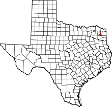 | |
| Town | ||
| Unincorporated community |
| |
| Footnotes | ‡This populated place also has portions in an adjacent county or counties | |