List of youth hostels in England and Wales
There are many youth hostels in England and Wales. This article is intended to list all youth hostels operated by the Youth Hostels Association (England & Wales) (YHA), either presently or formerly, and also independent hostels. The list is split into sections: hostels currently operated by YHA, independent hostels, and others, where others include former hostels previously operated by, or as part of, YHA some time since the creation of YHA in 1931. The primary sources for these lists are given in the references section.
The locations of hostels having coordinates listed (which should be just the current hostels) may be seen in linked OSM/Google/Bing map.
Current YHA hostels
This section lists the hostels believed to be be currently operated by, or as part of, YHA. This section was up-to-date as of December 2012.
| Name | Image | Location Grid Reference / Coordinates | Region[Notes 1] | County[Notes 2] | Year opened | Notes |
|---|---|---|---|---|---|---|
| Alstonefieldho | Gypsy Lane, Alstonefield SK 136 558 (Map: 119) 53°05′57″N 1°47′55″W / 53.099043°N 1.798700°W |
East Midlands | Derbyshire | 2001 | [1] | |
| Castleton Losehill Hall | Castleton, Hope Valley SK 153 838 (Map: 110) 53°21′04″N 1°46′15″W / 53.351139°N 1.770957°W |
East Midlands | Derbyshire | 2012 | [2] Previously Peak District National Park education centre | |
| Edale | Rowland Cote, Nether Booth, Edale, Hope Valley SK 140 866 (Map: 110) 53°22′34″N 1°47′28″W / 53.376148°N 1.791024°W |
East Midlands | Derbyshire | 1945 | [3] | |
| Eyam | Hawkhill Road, Eyam, Hope Valley SK 219 770 (Map: 119) 53°17′21″N 1°40′22″W / 53.289222°N 1.672672°W |
East Midlands | Derbyshire | 1970 | [4] | |
| Hathersage | Castleton Road, Hathersage, Hope Valley SK 228 815 (Map: 110) 53°19′48″N 1°39′32″W / 53.329896°N 1.658796°W |
East Midlands | Derbyshire | 1970 | [5] | |
| Hartington Hall | 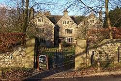 |
Hall Bank, Hartington, Buxton SK 132 603 (Map: 119) 53°08′24″N 1°48′17″W / 53.140123°N 1.804622°W |
East Midlands | Derbyshire | 1934 | [6] |
| Ravenstor | Millers Dale, Buxton SK 153 733 (Map: 119) 53°15′23″N 1°46′22″W / 53.256286°N 1.772844°W |
East Midlands | Derbyshire | 1938 | [7] | |
| Sherwood Forest |  |
SK 624 671 (Map: 120) 53°11′52″N 1°04′03″W / 53.197656°N 1.067374°W | East Midlands | Nottinghamshire | 1998 | |
| Thurlby | TF 100 169 (Map: 130) 52°44′18″N 0°22′17″W / 52.738278°N 0.371507°W | East Midlands | Lincolnshire | 1981 | ||
| Woody's Top | TF 334 783 (Map: 122) 53°17′04″N 0°00′01″W / 53.284560°N 0.000170°W | East Midlands | Lincolnshire | 1949 | ||
| Youlgreave | SK 211 643 (Map: 119) 53°10′30″N 1°41′11″W / 53.174997°N 1.686490°W | East Midlands | Derbyshire | 1975 | ||
| Blaxhall | TM 369 570 (Map: 156) 52°09′38″N 1°27′43″E / 52.160675°N 1.461941°E | East of England | Suffolk | 1964 | ||
| Cambridge | TL 461 575 (Map: 154) 52°11′48″N 0°08′08″E / 52.196688°N 0.135516°E | East of England | Cambridgeshire | 1945 | ||
| Hunstanton | TF 673 406 (Map: 132) 52°56′13″N 0°29′17″E / 52.936991°N 0.488189°E | East of England | Norfolk | 1972 | ||
| Sheringham | TG 160 429 (Map: 133) 52°56′23″N 1°12′46″E / 52.939587°N 1.212643°E | East of England | Norfolk | 1976 | ||
| Stour Valley | TM 120 339 (Map: 155) 51°57′48″N 1°05′02″E / 51.963318°N 1.083875°E | East of England | Suffolk | 2007 | ||
| Wells-next-the-Sea | TF 918 432 (Map: 132) 52°57′06″N 0°51′12″E / 52.951649°N 0.853195°E | East of England | Norfolk | 2002 | ||
| All Stretton | SO 454 955 (Map: 137) 52°33′17″N 2°48′24″W / 52.554822°N 2.806626°W | West Midlands (region) | Shropshire | 2007 | ||
| Bridges | SO 394 965 (Map: 137) 52°33′47″N 2°53′44″W / 52.563080°N 2.895520°W | West Midlands (region) | Shropshire | 1931 | ||
| Clun | SO 304 813 (Map: 137) 52°25′30″N 3°01′32″W / 52.424954°N 3.025661°W | West Midlands (region) | Shropshire | 1936 | ||
| Dimmingsdale | SK 053 436 (Map: 119) 52°59′24″N 1°55′23″W / 52.990125°N 1.923098°W | West Midlands (region) | Staffordshire | 1941 | ||
| Gradbach | SJ 994 661 (Map: 118) 53°11′30″N 2°00′39″W / 53.191745°N 2.010871°W | West Midlands (region) | Staffordshire | 1981 | ||
| Ilam Hall |  |
SK 132 507 (Map: 119) 53°03′11″N 1°48′19″W / 53.053087°N 1.805223°W | West Midlands (region) | Staffordshire | 1932 | |
| Ironbridge Coalbrookdale | SJ 670 043 (Map: 127) 52°38′08″N 2°29′19″W / 52.635508°N 2.488607°W | West Midlands (region) | Shropshire | 1980 | ||
| Ironbridge Coalport | SJ 696 024 (Map: 127) 52°37′08″N 2°27′02″W / 52.618843°N 2.450477°W | West Midlands (region) | Shropshire | 1980 | ||
| Kington | SO 301 568 (Map: 148) 52°12′19″N 3°01′28″W / 52.205325°N 3.024400°W | West Midlands (region) | Herefordshire | 2004 | ||
| Leominster | SO 498 593 (Map: 149) 52°13′48″N 2°44′10″W / 52.229900°N 2.736100°W | West Midlands (region) | Herefordshire | 2001 | ||
| Wilderhope Manor |  |
SO 545 929 (Map: 137) 52°31′55″N 2°40′19″W / 52.531842°N 2.671818°W | West Midlands (region) | Shropshire | 1938 | |
| National Forest | SK 306 157 (Map: 128) 52°44′16″N 1°32′56″W / 52.737864°N 1.548793°W | East Midlands | Derbyshire | 2008 | ||
| Stratford | SP 231 562 (Map: 151) 52°12′13″N 1°39′48″W / 52.203665°N 1.663415°W | West Midlands (region) | Warwickshire | 1948 | ||
| Welsh Bicknor | SO 591 177 (Map: 162) 51°51′24″N 2°35′41″W / 51.856629°N 2.594785°W | West Midlands (region) | Herefordshire | 1937 | ||
| London Holland Park |  |
TQ 249 797 (Map: 176) 51°30′09″N 0°12′05″W / 51.502630°N 0.201388°W | London | London | 1952 | In the surviving wing of the historic Holland House |
| London Central | TQ 290 819 (Map: 177) 51°31′17″N 0°08′33″W / 51.521335°N 0.142441°W | London | London | 2003 | ||
| London Earls Court | TQ 258 784 (Map: 176) 51°29′25″N 0°11′21″W / 51.490384°N 0.189243°W | London | London | 1952 | ||
| London Lee Valley | TL 368 024 (Map: 166) 51°42′15″N 0°01′20″W / 51.704035°N 0.022321°W | London | London | 2007 | ||
| London Oxford Street | TQ 294 812 (Map: 176) 51°30′53″N 0°08′13″W / 51.514819°N 0.136818°W | London | London | 1990 | ||
| London St Pancras | TQ 301 828 (Map: 176) 51°31′44″N 0°07′35″W / 51.528809°N 0.126498°W | London | London | 1997 | ||
| London St Pauls | TQ 319 811 (Map: 176) 51°30′47″N 0°06′01″W / 51.513109°N 0.100406°W | London | London | 1975 | City of London | |
| London Thameside |  |
TQ 357 802 (Map: 177) 51°30′16″N 0°02′47″W / 51.504370°N 0.046370°W | London | London | 1992 | |
| Alnwick | NU 187 131 (Map: 81) 55°24′42″N 1°42′22″W / 55.411739°N 1.706076°W | North East | Northumberland | 2011 | ||
| Bellingham | NY 840 833 (Map: 80) 55°08′37″N 2°15′09″W / 55.143627°N 2.252522°W | North East | Northumberland | 2008 | Different location to the previous hostel in Bellingham | |
| Berwick | NT 998 527 (Map: 75) 55°46′05″N 2°00′17″W / 55.768011°N 2.004699°W | North East | Northumberland | 2011 | ||
| Blackton Grange | NY 931 180 (Map: 91) 54°33′25″N 2°06′28″W / 54.556990°N 2.107840°W | North East | County Durham | 1979 | formerly known as Baldersdale | |
| Byrness | NT 764 027 (Map: 90) 55°19′05″N 2°22′22″W / 55.318100°N 2.372700°W | North East | Northumberland | 1972 | ||
| Durham | NZ 275 421 (Map: 88) 54°46′24″N 1°34′29″W / 54.773200°N 1.574600°W | North East | County Durham | 2012 | St Chad's College; Easter and summer holidays only | |
| Edmundbyers | NZ 018 501 (Map: 87) 54°50′43″N 1°58′26″W / 54.845396°N 1.973816°W | North East | County Durham | 1933 | ||
| Kielder | NY 632 932 (Map: 80) 55°13′55″N 2°34′46″W / 55.231858°N 2.579525°W | North East | Northumberland | 2002 | ||
| Langdon Beck | NY 860 305 (Map: 91) 54°40′09″N 2°13′06″W / 54.669200°N 2.218251°W | North East | County Durham | 1937 | ||
| Mounthooley | NT 882 226 (Map: 74/75) 55°29′48″N 2°11′21″W / 55.496771°N 2.189125°W | North East | Northumberland | 2008 | ||
| Ninebanks | NY 772 514 (Map: 86) 54°51′24″N 2°21′26″W / 54.856792°N 2.357281°W | North East | Northumberland | 1948 | ||
| Once Brewed | NY 753 669 (Map: 86) 54°59′46″N 2°23′18″W / 54.996081°N 2.388306°W | North East | Northumberland | 1934 | Roman Wall | |
| Wooler | NT 991 278 (Map: 75) 55°32′37″N 2°00′55″W / 55.543716°N 2.015297°W | North East | Northumberland | 1954 | ||
| Slaidburn |  |
SD 711 524 (Map: 103) 53°57′59″N 2°26′30″W / 53.966417°N 2.441575°W | North West | Lancashire | 1933 | |
| Alston | NY 717 461 (Map: 86) 54°48′32″N 2°26′31″W / 54.808934°N 2.441886°W | North West | Cumbria | 1976 | ||
| Ambleside | NY 377 031 (Map: 90) 54°25′09″N 2°57′43″W / 54.419170°N 2.961813°W | North West | Cumbria | 1972 | ||
| Arnside | SD 452 783 (Map: 97) 54°11′53″N 2°50′31″W / 54.197938°N 2.841910°W | North West | Cumbria | 1979 | ||
| Black Sail | NY 195 124 (Map: 89) 54°30′01″N 3°14′41″W / 54.500346°N 3.244845°W | North West | Cumbria | 1933 | ||
| Borrowdale | NY 256 143 (Map: 89/90) 54°31′08″N 3°09′01″W / 54.518760°N 3.150390°W | North West | Cumbria | 1939 | ||
| Buttermere | NY 178 169 (Map: 89) 54°32′26″N 3°16′18″W / 54.540418°N 3.271598°W | North West | Cumbria | 1956 | ||
| Carlisle | NY 395 561 (Map: 85) 54°53′45″N 2°56′42″W / 54.895728°N 2.945090°W | North West | Cumbria | 1998 | ||
| Cockermouth | NY 119 299 (Map: 89) 54°39′22″N 3°22′03″W / 54.656128°N 3.367444°W | North West | Cumbria | 1933 | ||
| Coniston Coppermines | SD 290 986 (Map: 96) 54°22′39″N 3°05′43″W / 54.377599°N 3.095299°W | North West | Cumbria | 1932 | ||
| Coniston Holly How | SD 302 981 (Map: 96) 54°22′24″N 3°04′32″W / 54.373310°N 3.075600°W | North West | Cumbria | 1950 | ||
| Dufton | NY 688 251 (Map: 91) 54°37′12″N 2°29′03″W / 54.619877°N 2.484206°W | North West | Cumbria | 1975 | ||
| Ennerdale | NY 142 141 (Map: 89) 54°30′53″N 3°19′36″W / 54.514804°N 3.326677°W | North West | Cumbria | 1970 | ||
| Eskdale | NY 195 011 (Map: 89) 54°23′56″N 3°14′29″W / 54.398900°N 3.241300°W | North West | Cumbria | 1938 | ||
| Grasmere Butharlyp Howe | NY 337 079 (Map: 90) 54°27′44″N 3°01′29″W / 54.462200°N 3.024655°W | North West | Cumbria | 1959 | Butterlip How | |
| Hawkshead | SD 355 967 (Map: 96) 54°21′42″N 2°59′41″W / 54.361697°N 2.994753°W | North West | Cumbria | 1942 | ||
| Helvellyn | NY 366 174 (Map: 90) 54°32′52″N 2°58′53″W / 54.547756°N 2.981393°W | North West | Cumbria | 1948 | ||
| Honister Hause | NY 225 136 (Map: 89) 54°30′41″N 3°11′52″W / 54.511433°N 3.197834°W | North West | Cumbria | 1942 | ||
| Keswick | NY 268 236 (Map: 89) 54°36′08″N 3°08′06″W / 54.602104°N 3.135020°W | North West | Cumbria | 1933 | ||
| Langdale | NY 338 053 (Map: 90) 54°26′19″N 3°01′17″W / 54.438570°N 3.021480°W | North West | Cumbria | 1955 | ||
| Liverpool | 895 (Map: 108) 53°23′53″N 2°59′11″W / 53.398000°N 2.986300°W | North West | Merseyside | 1997 | ||
| Manchester | Potato Wharf, Castlefield SJ 830 977 (Map: 109) 53°28′32″N 2°15′26″W / 53.475618°N 2.257352°W |
North West | Manchester | 1995 | [8] | |
| Patterdale | NY 399 157 (Map: 90) 54°31′57″N 2°55′50″W / 54.532633°N 2.930458°W | North West | Cumbria | 1971 | ||
| Skiddaw | NY 287 291 (Map: 89) 54°39′07″N 3°06′23″W / 54.652016°N 3.106266°W | North West | Cumbria | 2007 | Premises reopened after being closed for several years | |
| Wastwater | NY 145 045 (Map: 89) 54°25′43″N 3°19′11″W / 54.428558°N 3.319706°W | North West | Cumbria | 1969 | ||
| Windermere | NY 405 013 (Map: 90) 54°24′14″N 2°55′03″W / 54.403862°N 2.917495°W | North West | Cumbria | 1935 | ||
| Alfriston | TQ 518 020 (Map: 199) 50°47′50″N 0°09′09″E / 50.797274°N 0.152371°E | South East | East Sussex | 1953 | ||
| Arundel | TQ 033 075 (Map: 197) 50°51′26″N 0°32′03″W / 50.857352°N 0.534234°W | South East | West Sussex | 1946 | ||
| Blackboys | TQ 521 215 (Map: 199) 50°58′22″N 0°09′54″E / 50.972822°N 0.165058°E | South East | Sussex | 1944 | ||
| Brighstone | SZ 428 828 (Map: 196) 50°38′37″N 1°23′44″W / 50.643555°N 1.395457°W | South East | Isle of Wight | 2004 | ||
| Burley | SU 221 028 (Map: 195) 50°49′28″N 1°41′15″W / 50.824380°N 1.687614°W | South East | Hampshire | 1960 | ||
| Canterbury | TR 157 570 (Map: 179) 51°16′18″N 1°05′29″E / 51.271692°N 1.091335°E | South East | Kent | 1963 | ||
| Eastbourne | TV 588 990 (Map: 199) 50°46′09″N 0°15′02″E / 50.769104°N 0.250561°E | South East | East Sussex | 2009 | Rebuilt at same location as previous hostel | |
| Hindhead |  |
SU 893 369 (Map: 186) 51°07′27″N 0°43′29″W / 51.124273°N 0.724647°W | South East | Surrey | 1949 | |
| Holmbury | TQ 104 451 (Map: 187) 51°11′39″N 0°25′15″W / 51.194147°N 0.420847°W | South East | Surrey | 1935 | Harden Moss | |
| Jordans | SU 976 911 (Map: 175) 51°36′36″N 0°35′33″W / 51.610057°N 0.592401°W | South East | Buckinghamshire | 1933 | ||
| Littlehampton | TQ 026 020 (Map: 197) 50°48′30″N 0°32′43″W / 50.808272°N 0.545281°W | South East | West Sussex | 2003 | ||
| Margate | TR 342 705 (Map: 179) 51°23′06″N 1°21′51″E / 51.385120°N 1.364169°E | South East | Kent | 1998 | ||
| Medway | TQ 782 652 (Map: 178) 51°21′28″N 0°33′29″E / 51.357857°N 0.558034°E | South East | Kent | 1996 | ||
| Milton Keynes | SP 831 395 (Map: 152) 52°02′53″N 0°47′20″W / 52.047950°N 0.789000°W | South East | Buckinghamshire | 1982 | ||
| Oxford | SP 507 063 (Map: 164) 51°45′10″N 1°15′59″W / 51.752897°N 1.266399°W | South East | Oxfordshire | 2001 | ||
| South Downs | TQ 433 055 (Map: 198) 50°49′54″N 0°02′02″E / 50.831591°N 0.034021°E | South East | East Sussex | was due to open in 2013 | ||
| Streatley | SU 592 807 (Map: 174) 51°31′19″N 1°08′55″W / 51.521815°N 1.148734°W | South East | Berkshire | 1937 | ||
| Tanners Hatch |  |
TQ 140 516 (Map: 187) 51°15′07″N 0°22′03″W / 51.252025°N 0.367452°W | South East | Surrey | 1945 | |
| Telscombe | TQ 405 033 (Map: 198) 50°48′45″N 0°00′24″W / 50.812445°N 0.006569°W | South East | East Sussex | 1979 | ||
| Totland | SZ 325 865 (Map: 196) 50°40′38″N 1°32′30″W / 50.677089°N 1.541704°W | South East | Isle of Wight | 1975 | ||
| Truleigh Hill | TQ 223 106 (Map: 198) 50°52′55″N 0°15′46″W / 50.882035°N 0.262730°W | South East | West Sussex | 1968 | ||
| Okehampton | SX 592 944 (Map: 191) 50°43′56″N 3°59′46″W / 50.732191°N 3.996212°W | South West | Devon | 1997 | ||
| St Briavel's Castle |  |
SO 558 046 (Map: 162) 51°44′17″N 2°38′27″W / 51.738112°N 2.640796°W | South West | Gloucestershire | 1949 | |
| Bath | .jpg) |
ST 764 645 (Map: 172) 51°22′45″N 2°20′26″W / 51.379157°N 2.340667°W | South West | Somerset | 1954 | |
| Beer | SY 223 897 (Map: 192) 50°42′05″N 3°06′04″W / 50.701500°N 3.101095°W | South West | Devon | 1962 | ||
| Boscastle | SX 097 914 (Map: 190) 50°41′27″N 4°41′44″W / 50.690740°N 4.695582°W | South West | Cornwall | 1962 | Closed August 2004 - September 2006 due to flood damage | |
| Boswinger | SW 991 411 (Map: 105) 50°14′07″N 4°49′08″W / 50.235406°N 4.818937°W | South West | Cornwall | 1933 | ||
| Bristol | .jpg) |
ST 586 725 (Map: 172) 51°26′59″N 2°35′51″W / 51.449822°N 2.597445°W | South West | Bristol | 1988 | |
| Cheddar |  |
ST 456 535 (Map: 182) 51°16′40″N 2°46′55″W / 51.277688°N 2.781934°W | South West | Somerset | 1953 | |
| Cholderton | SU 210 424 (Map: 184) 51°10′49″N 1°42′06″W / 51.180234°N 1.701599°W | South West | Wiltshire | 2005 | ||
| Coverack | SW 783 181 (Map: 204) 50°01′18″N 5°05′49″W / 50.021776°N 5.096964°W | South West | Cornwall | 1976 | ||
| Dartmoor | SX 655 774 (Map: 191) 50°34′50″N 3°54′06″W / 50.580648°N 3.901563°W | South West | Devon | 1934 | Known as Bellever until 2012 | |
| Elmscott | SS 231 217 (Map: 190) 50°58′03″N 4°31′14″W / 50.967488°N 4.520579°W | South West | Devon | 1949 | ||
| Exeter | SX 941 898 (Map: 192) 50°41′54″N 3°30′02″W / 50.698466°N 3.500559°W | South West | Devon | 1939 | ||
| Exford | SS 853 383 (Map: 181) 51°07′58″N 3°38′27″W / 51.132639°N 3.640911°W | South West | Somerset | 1965 | ||
| Jersey - Durrell Wildlife Hostel | XD 946 254 (Map: ) 49°13′46″N 2°04′30″W / 49.229571°N 2.075129°W | Jersey | 2012 | |||
| Lands End | SW 364 305 (Map: 203) 50°06′57″N 5°41′18″W / 50.115914°N 5.688407°W | South West | Cornwall | 1939 | ||
| Litton Cheney | SY 549 900 (Map: 194) 50°42′28″N 2°38′25″W / 50.707703°N 2.640401°W | South West | Dorset | 1937 | ||
| Lizard Point | SW 703 116 (Map: 204) 49°57′36″N 5°12′13″W / 49.960124°N 5.203534°W | South West | Cornwall | 2003 | ||
| Lulworth Cove | SY 831 806 (Map: 194) 50°37′30″N 2°14′24″W / 50.625090°N 2.240025°W | South West | Dorset | 1983 | ||
| Minehead | .jpg) |
SS 973 442 (Map: 181) 51°11′16″N 3°28′15″W / 51.187860°N 3.470875°W | South West | Somerset | 1959 | |
| Okehampton Bracken Tor | SX 588 939 (Map: 191) 50°43′38″N 4°00′05″W / 50.727270°N 4.001400°W | South West | Devon | 2009 | ||
| Castle Horneck, Penzance | SW 458 303 (Map: 203) 50°07′05″N 5°33′29″W / 50.117926°N 5.557929°W | South West | Cornwall | 1950 | ||
| Perranporth | SW 752 544 (Map: 204) 50°20′46″N 5°09′42″W / 50.346100°N 5.161710°W | South West | Cornwall | 1982 | ||
| Pinkery | .jpg) |
SS 723 411 (Map: 180) 51°09′19″N 3°49′39″W / 51.155158°N 3.827394°W | South West | Somerset | 2007 | |
| Plymouth University | SX 482 549 (Map: 201) 50°22′27″N 4°08′09″W / 50.374115°N 4.135794°W | South West | Devon | 2012 | ||
| Portland | SY 685 739 (Map: 194) 50°33′50″N 2°26′46″W / 50.563974°N 2.446242°W | South West | Dorset | 2001 | ||
| Portreath | SW 669 443 (Map: 203) 50°15′10″N 5°16′15″W / 50.252762°N 5.270809°W | South West | Cornwall | 2007 | ||
| Salcombe | SX 728 374 (Map: 202) 50°13′23″N 3°47′02″W / 50.223036°N 3.783951°W | South West | Devon | 1938 | ||
| Salisbury | SU 150 300 (Map: 184) 51°04′09″N 1°47′16″W / 51.069101°N 1.787714°W | South West | Wiltshire | 1961 | ||
| Stow on the Wold | SP 192 258 (Map: 163) 51°55′50″N 1°43′22″W / 51.930670°N 1.722665°W | South West | Gloucestershire | 1935 | ||
| Street |  |
ST 480 346 (Map: 182) 51°06′29″N 2°44′38″W / 51.107921°N 2.743768°W | South West | Somerset | 1931 | |
| Swanage | SZ 031 785 (Map: 195) 50°36′22″N 1°57′28″W / 50.606150°N 1.957830°W | South West | Dorset | 1950 | ||
| Tintagel | SX 047 881 (Map: 200) 50°39′35″N 4°45′51″W / 50.659850°N 4.764200°W | South West | Cornwall | 1947 | ||
| Treyarnon | SW 858 741 (Map: 200) 50°31′40″N 5°01′22″W / 50.527642°N 5.022908°W | South West | Cornwall | 1948 | ||
| Westward Ho! | SS 431 290 (Map: 180) 51°02′20″N 4°14′23″W / 51.038784°N 4.239671°W | South West | Devon | 2009 | ||
| Pen y Pass | 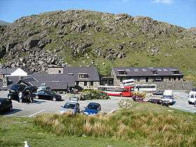 |
SH 647 556 (Map: 115) 53°04′51″N 4°01′15″W / 53.080876°N 4.020846°W | Wales | Gwynedd | 1970 | |
| Anglesey | SH 234 805 (Map: 114) 53°17′31″N 4°39′03″W / 53.291967°N 4.650924°W | Wales | Anglesey | 2007 | ||
| Betws-y-Coed | SH 766 577 (Map: 115) 53°06′07″N 3°50′42″W / 53.101990°N 3.845089°W | Wales | Gwynedd | 2003 | ||
| Borth | SN 608 907 (Map: 135) 52°29′47″N 4°03′06″W / 52.496522°N 4.051683°W | Wales | Ceredigion | 1953 | ||
| Brecon | SO 073 289 (Map: 160) 51°57′02″N 3°21′00″W / 51.950526°N 3.350090°W | Wales | Powys | 1944 | ||
| Broad Haven | SM 863 141 (Map: 157) 51°47′04″N 5°06′00″W / 51.784466°N 5.099968°W | Wales | Pembrokeshire | 1981 | ||
| Bryn Gwynant | SH 641 514 (Map: 17) 53°02′33″N 4°01′41″W / 53.042442°N 4.028061°W | Wales | Gwynedd | 1959 | ||
| Cardiff | ST 184 789 (Map: 171) 51°30′11″N 3°10′35″W / 51.502993°N 3.176452°W | Wales | South Glamorgan | 1986 | ||
| Conwy | SH 775 773 (Map: 115) 53°16′43″N 3°50′20″W / 53.278562°N 3.838888°W | Wales | Conwy | 1997 | ||
| Danywenallt National Park Study Centre | SO 108 206 (Map: 161) 51°52′36″N 3°17′52″W / 51.876570°N 3.297848°W | Wales | Powys | 2005 | ||
| Dolgoch | SN 806 562 (Map: 147) 52°11′28″N 3°44′52″W / 52.191029°N 3.747679°W | Wales | Ceredigion | 1976 | ||
| Gower | SS 468 853 (Map: 159) 51°32′46″N 4°12′38″W / 51.546104°N 4.210468°W | Wales | West Glamorgan | 2007 | ||
| Idwal Cottage | SH 649 604 (Map: 115) 53°07′24″N 4°01′14″W / 53.123287°N 4.020508°W | Wales | Gwynedd | 1931 | ||
| Kings | SH 684 160 (Map: 124) 52°43′32″N 3°57′03″W / 52.725661°N 3.950776°W | Wales | Gwynedd | 1937 | ||
| Llanberis | SH 574 597 (Map: 115) 53°06′55″N 4°07′56″W / 53.115312°N 4.132104°W | Wales | Gwynedd | 1940 | ||
| Llanddeusant | SN 777 245 (Map: 160) 51°54′21″N 3°46′43″W / 51.905790°N 3.778570°W | Wales | Camarthenshire | 1940 | ||
| Llangattock | SO 215 153 (Map: 161) 51°49′52″N 3°08′27″W / 51.831097°N 3.140727°W | Wales | Powys | 2007 | ||
| Llwyn-y-Celyn | SN 973 225 (Map: 160) 51°53′30″N 3°29′36″W / 51.891676°N 3.493255°W | Wales | Powys | 1972 | ||
| Manorbier | SS 080 977 (Map: 158) 51°38′41″N 4°46′35″W / 51.644801°N 4.776360°W | Wales | Pembrokeshire | 1987 | ||
| Marloes Sands | SM 778 080 (Map: 157) 51°43′37″N 5°13′07″W / 51.726955°N 5.218742°W | Wales | Pembrokeshire | 1978 | ||
| Newport | SN 059 392 (Map: 145) 52°01′02″N 4°49′51″W / 52.017354°N 4.830712°W | Wales | Pembrokeshire | 1995 | Formerly known as Trefdraeth | |
| Poppit Sands | SN 145 488 (Map: 145) 52°06′23″N 4°42′37″W / 52.106396°N 4.710276°W | Wales | Pembrokeshire | 1950 | ||
| Port Eynon | SS 468 848 (Map: 159) 51°32′29″N 4°12′35″W / 51.541374°N 4.209829°W | Wales | West Glamorgan | 1950 | ||
| Pwll Deri | SM 892 388 (Map: 157) 52°00′25″N 5°04′20″W / 52.007073°N 5.072266°W | Wales | Pembrokeshire | 1956 | ||
| Rhossili | SS 425 881 (Map: 145) 51°34′11″N 4°16′28″W / 51.569640°N 4.274508°W | Wales | West Glamorgan | 2007 | ||
| Rowen | SH 747 721 (Map: 115) 53°13′52″N 3°52′45″W / 53.230980°N 3.879091°W | Wales | Conwy | 1948 | ||
| Snowdon Ranger | SH 565 550 (Map: 115) 53°04′24″N 4°08′36″W / 53.073296°N 4.143262°W | Wales | Gwynedd | 1939 | ||
| St Davids | SM 740 277 (Map: 157) 51°54′08″N 5°17′12″W / 51.902160°N 5.286795°W | Wales | Pembrokeshire | 1973 | ||
| Swansea | SS 616 899 (Map: 159) 51°35′28″N 3°59′57″W / 51.591200°N 3.999300°W | Wales | West Glamorgan | 2007 | ||
| Tyncornel | SN 751 535 (Map: 147) 52°09′56″N 3°49′41″W / 52.165525°N 3.828126°W | Wales | Ceredigion | 1967 | ||
| Beverley Friary | TA 039 393 (Map: 107) 53°50′23″N 0°25′22″W / 53.839690°N 0.422850°W | Yorkshire and the Humber | East Yorkshire | 1984 | ||
| Boggle Hole | NZ 954 040 (Map: 94) 54°25′22″N 0°31′53″W / 54.422785°N 0.531346°W | Yorkshire and the Humber | North Yorkshire | 1952 | ||
| Bretton | SK 200 780 (Map: 119) 53°17′56″N 1°42′03″W / 53.298809°N 1.700928°W | Yorkshire and the Humber | South Yorkshire | 1942 | ||
| Earby | SD 915 469 (Map: 103) 53°55′05″N 2°07′50″W / 53.918079°N 2.130656°W | North West | Lancashire | 1955 | ||
| Grinton Lodge |  |
SE 048 976 (Map: 98) 54°22′26″N 1°55′38″W / 54.373774°N 1.927156°W | Yorkshire and the Humber | North Yorkshire | 1949 | |
| Hawes | SD 868 898 (Map: 98) 54°18′13″N 2°12′14″W / 54.303579°N 2.203832°W | Yorkshire and the Humber | North Yorkshire | 1972 | ||
| Haworth | SE 039 378 (Map: 104) 53°50′13″N 1°56′32″W / 53.836840°N 1.942332°W | Yorkshire and the Humber | West Yorkshire | 1976 | ||
| Helmsley | SE 615 840 (Map: 100) 54°14′54″N 1°03′26″W / 54.248285°N 1.057220°W | Yorkshire and the Humber | North Yorkshire | 1964 | ||
| Ingleton | SD 696 734 (Map: 98) 54°09′18″N 2°28′04″W / 54.155057°N 2.467694°W | North West | Lancashire | 1938 | ||
| Kettlewell | SD 971 724 (Map: 98) 54°08′50″N 2°02′48″W / 54.147330°N 2.046590°W | Yorkshire and the Humber | North Yorkshire | 1943 | ||
| Leeds Carnegie Village | SE 267 367 (Map: 104) 53°49′35″N 1°35′43″W / 53.826281°N 1.595369°W | Yorkshire and the Humber | West Yorkshire | 2012 | ||
| Leeds Kirkstall Brewery | SE 258 355 (Map: 104) 53°48′56″N 1°36′34″W / 53.815434°N 1.609386°W | Yorkshire and the Humber | West Yorkshire | 2012 | ||
| Leeds Opal | SE 288 340 (Map: 104) 53°48′04″N 1°33′51″W / 53.801095°N 1.564091°W | Yorkshire and the Humber | West Yorkshire | 2012 | ||
| Leeds Queenswood | SE 266 366 (Map: 104) 53°49′31″N 1°35′49″W / 53.825371°N 1.596913°W | Yorkshire and the Humber | West Yorkshire | 2012 | ||
| Lockton | SE 844 900 (Map: 94) 54°17′55″N 0°42′18″W / 54.298660°N 0.704949°W | Yorkshire and the Humber | North Yorkshire | 1978 | ||
| Malham | SD 901 630 (Map: 98) 54°03′45″N 2°09′07″W / 54.062513°N 2.152044°W | Yorkshire and the Humber | North Yorkshire | 1949 | ||
| Mankinholes | Mankinholes, Todmorden SD 960 236 (Map: 103) 53°42′31″N 2°03′43″W / 53.708477°N 2.061909°W |
North West | Lancashire | 1943 | [9] | |
| Osmotherley | SE 461 981 (Map: 100) 54°22′35″N 1°17′30″W / 54.376449°N 1.291559°W | Yorkshire and the Humber | North Yorkshire | 1981 | opened in same premises as original hostel at location | |
| Scarborough | TA 026 908 (Map: 101) 54°18′08″N 0°25′28″W / 54.302293°N 0.424379°W | Yorkshire and the Humber | North Yorkshire | 1936 | ||
| Whitby | NZ 903 111 (Map: 94) 54°29′15″N 0°36′30″W / 54.487423°N 0.608271°W | Yorkshire and the Humber | North Yorkshire | 2007 | ||
| York | SE 590 529 (Map: 105) 53°58′07″N 1°06′10″W / 53.968511°N 1.102822°W | Yorkshire and the Humber | North Yorkshire | 1946 |
Independent hostels
Hostels currently outside the YHA system include:
| Name | Image | Location Grid Reference / Coordinates | Years opened as a YHA hostel | Hostel also known as | Notes | |
|---|---|---|---|---|---|---|
| Elterwater | Cumbria | 1939-2013 | Reopened in 2013 as an independent hostel: Elterwater Hostel | |||
| Grasmere (Thorney How) | Cumbria | 1933-2011 | Reopened Easter 2011 as an independent hostel: Thorney How Independent Hostel | |||
| Hareshaw[10] | Woodburn Road, Bellingham, Hexham NY 843 834 55°08′43″N 2°14′49″W / 55.145301°N 2.247068°W |
Northumberland | 1936-2006 | On the Pennine Way.[10] Location of former YHA Bellingham hostel (distinct from current YHA Bellingham).[11]:23 | ||
Other hostels, including former ones

This section lists the locations of former hostels, including all those which have been operated by, or as part of YHA, at some time since 1931. The majority of the hostels in this section have closed, but there may be some that now operate as independent hostels that are no longer part of YHA (if any of these are identified, they should be moved to the section above).
| Name | Image | Year opened as YHA | Year closed as YHA | Hostel also known as | Notes | |
|---|---|---|---|---|---|---|
| Abergavenny | Monmouthshire | 1933 | 1937 | Pantyrohen | ||
| Abergele | Conwy | 1938 | 1946 | |||
| Abermule | Powys | 1949 | 1952 | |||
| Acomb | Northumberland | 1933 | 2006 | |||
| Albury | Surrey | 1931 | 1933 | Surrey Hills | ||
| Allendale | Northumberland | 1937 | 1937 | |||
| Allendale | Northumberland | 1945 | 1966 | |||
| Alnham | Northumberland | 1932 | 1958 | |||
| Alpheton | Suffolk | 1982 | 1992 | |||
| Alston | Cumbria | 1933 | 1955 | |||
| Ambleside | Isle of Man | 1946 | 1971 | |||
| Amersham On The Hill | Buckinghamshire | 1934 | 1934 | |||
| Ampleforth | North Yorkshire | 1934 | 1959 | |||
| Andreas | Isle of Man | 1948 | 1952 | |||
| Arnside | Cumbria | 1946 | 1978 | |||
| Arrad Foot | Cumbria | 1940 | 1944 | |||
| Asenby | North Yorkshire | 1934 | 1939 | |||
| Ashover | Derbyshire | 1933 | 1939 | |||
| Ashton Keynes | Wiltshire | 1936 | 1965 | |||
| Askrigg | North Yorkshire | 1935 | 1950 | |||
| Astwell Castle | Northamptonshire | 1935 | 1953 | |||
| Aveton Gifford | Devon | 1937 | 1938 | |||
| Awebridge | Hampshire | 1943 | 1943 | |||
| Aylburton | Gloucestershire | 1944 | 1948 | |||
| Aysgarth Falls | North Yorkshire | 1951 | 2003 | |||
| Badby | Northamptonshire | 1933 | 2005 | |||
| Badminton | Gloucestershire | 1932 | 1936 | |||
| Badwell Ash | Suffolk | 1935 | 1935 | |||
| Bakewell | Derbyshire | 1966 | 2007 | |||
| Bala | Gwynedd | 1933 | 1996 | Plas Rhiwaedog | ||
| Baldersdale | Durham | 1980 | 2006 | |||
| Ballasalla | Isle of Man | 1946 | 1953 | |||
| Bampton | Devon | 1932 | 1971 | |||
| Bangor | Gwynedd | 1938 | 1964 | |||
| Bangor | Gwynedd | 1965 | 2009 | |||
| Bardon | Leicestershire | 1942 | 1942 | |||
| Barnard Castle | Durham | 1931 | 1983 | |||
| Barnstaple | Devon | 1933 | 1951 | |||
| Barnston In Wirral | Cheshire | 1955 | 1960 | |||
| Barrow Hill | Staffordshire | 1943 | 1947 | |||
| Barrow House | Cumbria | 1931 | 1931 | |||
| Barsham | Suffolk | 1952 | 1952 | |||
| Bassenthwaite Lake | Cumbria | 1952 | 1954 | |||
| Batheaston | Somerset | 1931 | 1953 | |||
| Battle | East Sussex | 1944 | 1944 | Hostel listed in 1944 handbook but no confirmation that opening ever occurred | ||
| Battlesden | Buckinghamshire | 1949 | 1949 | |||
| Bawtry | South Yorkshire | 1951 | 1972 | |||
| Beacons Bottom | Buckinghamshire | 1963 | 1963 | |||
| Bedruthen Steps | Cornwall | 1939 | 1939 | |||
| Bempton | East Riding of Yorkshire | 1937 | 1940 | |||
| Bennetston Hall | Derbyshire | 1936 | 1945 | |||
| Bettiscombe | Dorset | 1943 | 1944 | |||
| Betws-Y-Coed | Conwy | 1945 | 1983 | Oaklands | ||
| Bexley | Kent | 1933 | 1933 | |||
| Biddisham | Somerset | 1943 | 1951 | |||
| Bigbury On Sea | Devon | 1944 | 1988 | |||
| Bilsdale | North Yorkshire | 1937 | 1937 | |||
| Birdsall Brow | North Yorkshire | 1936 | 1936 | |||
| Birley Edge | South Yorkshire | 1945 | 1945 | |||
| Birmingham | Warwickshire | 1988 | 1996 | |||
| Bishops Stortford | Hertfordshire | 1931 | 1943 | Cliff Cottage | ||
| Bishopsdale | North Yorkshire | 1947 | 1950 | |||
| Bishopsdale | North Yorkshire | 2004 | 2009 | |||
| Bishopstone | Wiltshire | 1933 | 1939 | |||
| Blackdown Mill | Warwickshire | 1932 | 1932 | |||
| Blackmore | Essex | 1935 | 1935 | |||
| Blaencaron | Ceredigion | 1950 | 2006 | |||
| Bodlonfa Hall | Denbighshire | 1943 | 1955 | Bodlonfa Cwm | ||
| Bognor | West Sussex | 1935 | 1935 | |||
| Bolt Head | Devon | 1932 | 1934 | Bolberry Farm | ||
| Bonsall | Derbyshire | 1931 | 1931 | |||
| Boulby Cliff | North Yorkshire | 1932 | 1935 | |||
| Boulters Lock | Berkshire | 1938 | 1940 | |||
| Bournemouth | Dorset | 1936 | 1936 | |||
| Bowbank | Durham | 1936 | 1942 | Middleton in Teesdale | ||
| Bracknell | Berkshire | 1949 | 1955 | |||
| Bradda Head | Isle of Man | 1954 | 1975 | |||
| Bradenham | Buckinghamshire | 1964 | 2005 | |||
| Bradwell On Sea | Essex | 1950 | 1969 | Bradwell-Juxta-Mare | ||
| Brandon | Essex | 1979 | 1997 | Thetford Forest | ||
| Brassington | Derbyshire | 1943 | 1952 | |||
| Bratton | Wiltshire | 1933 | 1933 | |||
| Breachwood Green | Hertfordshire | 1938 | 1940 | |||
| Brede | East Sussex | 1937 | 1937 | |||
| Brendon | Devon | 1931 | 1953 | Rockford Lodge | ||
| Brentmoor | Devon | 1945 | 1954 | |||
| Bricket Wood | Hertfordshire | 1931 | 1931 | |||
| Bridgwater | Somerset | 1935 | 1940 | |||
| Bridlington | East Riding of Yorkshire | 1946 | 1965 | |||
| Bridport | Dorset | 1933 | 1938 | |||
| Bridport | Dorset | 1939 | 1975 | |||
| Bridport | Dorset | 1976 | 1995 | |||
| Brighton | West Sussex | 1939 | 2007 | Patcham | ||
| Bristol | Bristol | 1949 | 1966 | |||
| Bristol | Bristol | 1982 | 1988 | |||
| Brixham | Devon | 1939 | 1944 | |||
| Broadstairs | Kent | 1992 | 2004 | |||
| Brockweir | Monmouthshire | 1931 | 1932 | |||
| Brodenhill | Devon | 1949 | 1954 | |||
| Broom | Warwickshire | 1944 | 1968 | |||
| Broughton | Northamptonshire | 1944 | 1952 | |||
| Broughton Astley | Leicestershire | 1940 | 1940 | |||
| Bryn Hall | Gwynedd | 1946 | 1970 | |||
| Bryn Poeth Uchaf |  |
Carmarthenshire | 1969 | 1998 | ||
| Bucklebury | Berkshire | 1935 | 1941 | |||
| Bude | Cornwall | 1938 | 1938 | |||
| Bude | Cornwall | 1939 | 1939 | |||
| Bungay | Suffolk | 1945 | 1951 | |||
| Buntingford | Hertfordshire | 1931 | 1935 | Wayside | ||
| Buntingford | Hertfordshire | 1936 | 1937 | |||
| Burley | Hampshire | 1936 | 1954 | |||
| Burley Woodhead | West Yorkshire | 1945 | 1970 | |||
| Burrington | Somerset | 1943 | 1954 | |||
| Burton Lazars | Leicestershire | 1939 | 1939 | |||
| Burton Le Coggles | Lincolnshire | 1940 | 1940 | |||
| Burwash Weald | East Sussex | 1937 | 1937 | |||
| Buxton | Derbyshire | 1941 | 2002 | |||
| Cae Dafydd | Gwynedd | 1934 | 1958 | |||
| Caistor | Lincolnshire | 1936 | 1940 | |||
| Caldbeck | Cumbria | 1933 | 1933 | |||
| Calshot | Hampshire | 1994 | 1995 | |||
| Cambridge | Cambridgeshire | 1935 | 1938 | |||
| Cambridge | Cambridgeshire | 1939 | 1939 | |||
| Canterbury | Kent | 1932 | 1939 | |||
| Canterbury | Kent | 1946 | 2006 | |||
| Canterbury Old House | Kent | 1931 | 1931 | |||
| Capel | Surrey | 1933 | 1942 | |||
| Capel Curig | Conwy | 1946 | 2011 | |||
| Capel-Y-Ffin | Powys | 1944 | 1947 | |||
| Capel-Y-Ffin | Powys | 1949 | 1951 | |||
| Capel-Y-Ffin | Powys | 1952 | 1952 | |||
| Capel-Y-Ffin | Powys | 1958 | 2007 | |||
| Carisbrook | Isle of Wight | 1948 | 1949 | |||
| Carlisle | Cumbria | 1935 | 1940 | |||
| Carlisle | Cumbria | 1954 | 1997 | |||
| Carrock Fell | Cumbria | 1982 | 2002 | |||
| Cassington | Oxfordshire | 1932 | 1932 | |||
| Castle Acre | Norfolk | 1987 | 1989 | |||
| Castle Hedingham | Essex | 1937 | 2008 | |||
| Castleton | North Yorkshire | 1931 | 1931 | |||
| Castleton | Derbyshire | 1937 | 1945 | |||
| Castleton | North Yorkshire | 1932 | 1946 | |||
| Caton | Lancashire | 1934 | 1937 | |||
| Cefn-Y-Coed | Powys | 1953 | 1957 | |||
| Cerne Abbas | Dorset | 1932 | 1955 | |||
| Chaddesley Corbett | Worcestershire | 1945 | 1965 | |||
| Chaldon | Surrey | 1936 | 1965 | |||
| Chalfont St. Giles | Buckinghamshire | 1943 | 1943 | |||
| Charing | Kent | 1931 | 1937 | |||
| Charlbury | Oxfordshire | 1946 | 2001 | |||
| Charney Bassett | Berkshire | 1944 | 1948 | |||
| Charnwood Forest | Leicestershire | 1933 | 1940 | |||
| Cheltenham | Gloucestershire | 1931 | 1931 | |||
| Chelwood Gate | East Sussex | 1934 | 1939 | |||
| Chepstow | Monmouthshire | 1937 | 1940 | |||
| Chepstow | Monmouthshire | 1941 | 1945 | |||
| Chepstow (Severn Bridge) | Monmouthshire | 1946 | 1991 | Severn Bridge | ||
| Chepstow (Tutshill) | Monmouthshire | 1933 | 1935 | Tutshill | ||
| Chesham | Buckinghamshire | 1935 | 1942 | |||
| Chester | Cheshire | 1933 | 1933 | |||
| Chester | Cheshire | 1934 | 1951 | |||
| Chester | Cheshire | 1952 | 1962 | |||
| Chester | Cheshire | 1963 | 2009 | |||
| Chilton | Berkshire | 1935 | 1935 | |||
| Chisworth | Derbyshire | 1933 | 1946 | |||
| Cholderton Hill | Hampshire | 1954 | 1957 | |||
| Cilcewydd | Powys | 1931 | 1933 | |||
| Cilibion | Swansea | 1950 | 1969 | |||
| Cleethorpes | Lincolnshire | 1957 | 1961 | |||
| Cleeve Hill | Gloucestershire | 1937 | 1995 | |||
| Clent | Worcestershire | 1934 | 1957 | |||
| Cleobury Mortimer | Worcestershire | 1933 | 1936 | |||
| Clevedon | Somerset | 1952 | 1962 | |||
| Clifton On Teme | Worcestershire | 1952 | 1960 | |||
| Cloughton | North Yorkshire | 1931 | 1934 | Cober Hill Bungalows | ||
| Clun | Shropshire | 1933 | 1935 | |||
| Coalport | Shropshire | 1998 | 1998 | |||
| Cocking | West Sussex | 1934 | 1935 | Men only | ||
| Coedkernew | Monmouthshire | 1933 | 1936 | |||
| Colby | Isle of Man | 1939 | 1946 | |||
| Colchester | Essex | 1936 | 1945 | |||
| Colchester | Essex | 1949 | 1996 | East Bay House[12] | TM 00656 25240 | |
| Colwyn Bay | Conwy | 1955 | 1996 | |||
| Comberton | Worcestershire | 1937 | 1938 | |||
| Copt Oak | Leicestershire | 1960 | 2002 | |||
| Corney | Cumbria | 1935 | 1941 | |||
| Corris | Gwynedd | 1962 | 2005 | |||
| Corris (Ratgoed) | Gwynedd | 1943 | 1947 | Ratgoed | ||
| Coventry | Warwickshire | 1962 | 1962 | Temporary hostel during the Coventry festival 1962 | ||
| Cowes | Isle of Wight | 1950 | 1969 | |||
| Crafnant | Conwy | 1951 | 1953 | |||
| Cranbourne | Dorset | 1944 | 1992 | |||
| Crickhowell | Powys | 1937 | 1982 | |||
| Crockham Hill | Kent | 1946 | 1992 | |||
| Croscombe | Somerset | 1943 | 1967 | |||
| Cross In Hand | East Sussex | 1936 | 1940 | |||
| Crosscliff | North Yorkshire | 1958 | 1960 | |||
| Crossthwaite | Cumbria | 1931 | 1964 | |||
| Crowcombe | Somerset | 1940 | 2006 | |||
| Crowden | East Midlands: Derbyshire |
1965 | 2006 | Located in Crowden, Glossop.[11]:99 | ||
| Crowden | East Midlands: Derbyshire |
2007 | 2014 | Located in Crowden, Glossop. Moved 1 mile from former YHA Crowden location.[11]:99 | ||
| Croxton | Norfolk | 1936 | 1951 | |||
| Cudham | Kent | 1950 | 1965 | |||
| Cwm Ystadllyn | Gwynedd | 1949 | 1952 | |||
| Cynwyd | Denbighshire | 1933 | 2005 | |||
| Dacre Banks | North Yorkshire | 1932 | 1987 | |||
| Dartington | Devon | 1932 | 2006 | Week, Lownard | ||
| Dartmeet | Devon | 1931 | 1933 | |||
| Delamere Forest | Cheshire | 1935 | 1973 | |||
| Dentdale | Cumbria | 1944 | 2006 | |||
| Derwent | Derbyshire | 1933 | 1942 | |||
| Dinas Mawddwy | Powys | 1962 | 1984 | |||
| Dirt Pot | Northumberland | 1949 | 1972 | |||
| Doddington | Kent | 1948 | 1980 | |||
| Dover (Barnet Hut) | Kent | 1931 | 1940 | |||
| Dover (Town) | Kent | 1955 | 1981 | |||
| Dover (Central) | Kent | 1966 | 2007 | |||
| Dover (Seafront) | Kent | 1947 | 1966 | |||
| Dovercourt | Essex | 1975 | 1975 | |||
| Downderry | Devon | 1935 | 1940 | |||
| Draethen | Caerphilly | 1938 | 1938 | Hostel listed in 1938 handbook but no confirmation that opening ever occurred | ||
| Duddon | Cumbria | 1934 | 1944 | |||
| Duddon | Cumbria | 1965 | 1984 | |||
| Duddon Estuary | Cumbria | 1999 | 2007 | |||
| Duddon Vally | Cumbria | 1945 | 1963 | |||
| Duddon Vally (Lower) | Cumbria | 1951 | 1955 | |||
| Dufton | Cumbria | 1935 | 1943 | |||
| Duntisbourne Abbots | Gloucestershire | 1946 | 2001 | |||
| Dunwich | Suffolk | 1946 | 1946 | |||
| Durham | Durham | 1978 | 1986 | |||
| Durham | Durham | 1987 | 1995 | |||
| Durham City | Durham | 1936 | 1940 | |||
| Dursley | Gloucestershire | 1933 | 1941 | |||
| East Cowes | Isle of Wight | 1934 | 1945 | |||
| East Marden | West Sussex | 1952 | 1969 | |||
| Eastbourne | East Sussex | 1974 | 2004 | Beachy Head | ||
| Easthope | Shropshire | 1932 | 1935 | Easthope Manor | ||
| Eastwell | Leicestershire | 1933 | 1938 | |||
| Ebford (Exeter) | Devon | 1933 | 1935 | |||
| Edale Valley | Derbyshire | 1940 | 1945 | |||
| Edgworth | Lancashire | 1936 | 1940 | |||
| Elkington | Lincolnshire | 1949 | 1954 | |||
| Ellingstring | North Yorkshire | 1941 | 2003 | picture on Geograph | ||
| Elton | Derbyshire | 1943 | 2002 | |||
| Ely | Cambridgeshire | 1948 | 1966 | |||
| Ely | Cambridgeshire | 1974 | 1986 | |||
| Ely | Cambridgeshire | 1987 | 1995 | |||
| Endmoor | Cumbria | 1935 | 1942 | |||
| Ennerdale | Cumbria | 1942 | 1967 | Gillerthwaite | ||
| Epping Forest | Essex | 1933 | 1943 | Buckhurst Hill | ||
| Epping Forest | Essex | 1964 | 2008 | TQ 408 983 Picture on Geograph | ||
| Erwood | Powys | 1937 | 1945 | |||
| Eskdale | Cumbria | 1933 | 1938 | |||
| Eskett | Cumbria | 1932 | 1951 | Ennerdale, Ennerdale Hall | ||
| Euston | London | 1945 | 1945 | |||
| Ewden | South Yorkshire | 1945 | 1966 | |||
| Ewhurst Green | Surrey | 1936 | 1983 | |||
| Exford | Somerset | 1935 | 1960 | |||
| Fairlight | East Sussex | 1939 | 1940 | |||
| Falmouth | Cornwall | 1938 | 1951 | |||
| Farforth | Lincolnshire | 1935 | 1948 | |||
| Farley Hall | Staffordshire | 1937 | 1939 | |||
| Farndale | North Yorkshire | 1957 | 1963 | |||
| Farnham | Surrey | 1938 | 1940 | |||
| Felixstowe | Suffolk | 1936 | 1945 | |||
| Felixstowe | Suffolk | 1946 | 1959 | |||
| Fenwick | Northumberland | 1946 | 1954 | |||
| Ferryside | Carmarthenshire | 1937 | 1938 | |||
| Ffestiniog | Gwynedd | 1937 | 1937 | |||
| Ffestiniog | Gwynedd | 1938 | 1995 | |||
| Ffynon Wen | Ceredigion | 2007 | 2008 | |||
| Filey | North Yorkshire | 1938 | 1940 | |||
| Filey | North Yorkshire | 1946 | 1958 | |||
| Finningham | Suffolk | 1943 | 1968 | |||
| Fiskerton | Nottinghamshire | 1937 | 1937 | |||
| Flackwell Heath | Buckinghamshire | 1931 | 1940 | Woodspring | ||
| Flagg | Derbyshire | 1931 | 1932 | |||
| Fordingbridge | Hampshire | 1979 | 1980 | |||
| Forest Green | Surrey | 1940 | 1940 | |||
| Forest Lodge | Powys | 1934 | 1940 | |||
| Fort Purboof | Hampshire | 1938 | 1939 | |||
| Four Marks | Hampshire | 1931 | 1937 | Holly Bush House | ||
| Four Marks | Hampshire | 1940 | 1940 | |||
| Fowey | Cornwall | 1943 | 1943 | |||
| Freshwater Bay | Isle of Wight | 1972 | 1973 | |||
| Frosterley | Durham | 1934 | 1940 | |||
| Fulshaw | South Yorkshire | 1942 | 1952 | |||
| Gara Mill | Devon | 1931 | 1949 | |||
| Garsdale Head | North Yorkshire | 1949 | 1983 | |||
| Gaydon | Warwickshire | 1931 | 1931 | |||
| Gerddi Bluog | Gwynedd | 1977 | 1982 | |||
| Gidleigh | Devon | 1932 | 1988 | picture on Geograph | ||
| Gilsand | Cumbria | 1933 | 1940 | |||
| Gisburn | Lancashire | 1934 | 1940 | |||
| Glamorgan Coast | Vale of Glamorgan | 1937 | 1937 | |||
| Glascwm | Powys | 1947 | 1997 | |||
| Glentham | Lincolnshire | 1938 | 1942 | |||
| Glossop | Derbyshire | 1939 | 1940 | |||
| Godsfield | Hampshire | 1933 | 1938 | |||
| Godshill | Hampshire | 1931 | 1938 | |||
| Godshill | Hampshire | 1944 | 1944 | |||
| Godstone | Kent | 1932 | 1935 | Surrey Crest | ||
| Golant | Cornwall | 1970 | 2014 | Currently a private house | ||
| Goodings | Berkshire | 1965 | 1971 | |||
| Gosport | Hampshire | 1951 | 1961 | |||
| Goudhurst | Kent | 1943 | 1982 | |||
| Goyt Valley | Derbyshire | 1931 | 1935 | Errwood Hall Farm | ||
| Graffham | West Sussex | 1939 | 1947 | |||
| Grange | Cumbria | 1933 | 1973 | Borrowdale B | ||
| Grantham | Lincolnshire | 1951 | 1957 | |||
| Grantham | Lincolnshire | 1958 | 1986 | |||
| Grassington | North Yorkshire | 1933 | 1939 | |||
| Great Bavington | Northumberland | 1949 | 1959 | |||
| Great Stambridge | Essex | 1979 | 1983 | |||
| Great Walsingham | Norfolk | 1940 | 1940 | |||
| Great Witley | Worcestershire | 1947 | 1948 | |||
| Great Yarmouth | Norfolk | 1950 | 2008 | |||
| Greenhead | Cumbria | 1979 | 2009 | |||
| Greenmoor | South Yorkshire | 1945 | 1948 | |||
| Greens Norton | Northamptonshire | 1952 | 1983 | |||
| Gretna | Cumbria | 1933 | 1936 | |||
| Grosmont | Herefordshire | 1933 | 1933 | |||
| Gwydyr Uchaf | Denbighshire | 1931 | 1954 | |||
| Gwynant | Powys | 1933 | 1933 | |||
| Gyffylliog | Denbighshire | 1931 | 1953 | |||
| Hackness | North Yorkshire | 1934 | 1945 | |||
| Hagg Farm | Derbyshire | 1973 | 1988 | |||
| Halesworth | Suffolk | 1933 | 1940 | |||
| Hampstead Heath | London | 1980 | 2006 | |||
| Hampton Loade | Shropshire | 1931 | 1934 | |||
| Hannington | Hampshire | 1946 | 1961 | |||
| Hanwell | Oxfordshire | 1948 | 1957 | |||
| Harlech | Gwynedd | 1938 | 1990 | Pen y Garth | ||
| Harlow | Essex | 1968 | 1998 | |||
| Harrowby | Lincolnshire | 1944 | 1950 | |||
| Hartington | Derbyshire | 1933 | 1934 | |||
| Harwich | Suffolk | 1935 | 1937 | |||
| Harwich | Essex | 1968 | 1974 | |||
| Haslingfield | Cambridgeshire | 1934 | 1936 | |||
| Hastings | East Sussex | 1955 | 2006 | Guestling | ||
| Hatfield Forest | Hertfordshire | 1969 | 1971 | |||
| Hathaway Farm | Warwickshire | 1931 | 1931 | |||
| Hawkinge | Kent | 1952 | 1954 | |||
| Haworth | West Yorkshire | 1950 | 1958 | |||
| Hayle | Cornwall | 1947 | 1982 | Phillack | ||
| Hayling Island | Hampshire | 1931 | 1931 | |||
| Heasley Mill | Devon | 1949 | 1951 | |||
| Heath Charnock | Lancashire | 1934 | 1935 | |||
| Hebden Bridge | West Yorkshire | 1932 | 1934 | |||
| Heltondale | Cumbria | 1936 | 1946 | |||
| Hemel Hempstead | Hertfordshire | 1933 | 1951 | |||
| Henley On Thames | Oxfordshire | 1935 | 1985 | |||
| Heol Senni | Powys | 1941 | 1949 | |||
| Hesket Newmarket | Cumbria | 1934 | 1937 | |||
| Heys Farm Guest House | Lancashire | 1931 | 1932 | |||
| High Flatts | West Yorkshire | 1934 | 1943 | |||
| High Halden | Kent | 1944 | 1950 | |||
| High Kelling | Norfolk | 1933 | 1939 | |||
| High Roding | Essex | 1936 | 1964 | |||
| Highgate Village | London | 1936 | 1997 | |||
| Hildenborough | Kent | 1933 | 1934 | |||
| Hilltop Hostel | Hampshire | 1931 | 1932 | |||
| Hockley | Essex | 1936 | 1960 | |||
| Hodgeston Hill | Pembrokeshire | 1951 | 1965 | |||
| Holbeach | Lincolnshire | 1955 | 1961 | |||
| Holmfirth | West Yorkshire | 1937 | 1968 | Harden Moss | ||
| Holmpton | East Riding of Yorkshire | 1954 | 1956 | |||
| Holt | Worcestershire | 1934 | 1942 | |||
| Holyhead | Isle of Anglesey | 1936 | 1939 | |||
| Holyhead | Isle of Anglesey | 2003 | 2000 | |||
| Hope | Derbyshire | 1931 | 1933 | Birchfields | ||
| Horndean | Hampshire | 1934 | 1936 | |||
| Horton In Ribblesdale | North Yorkshire | 1934 | 1939 | |||
| Houghton Mill | Cambridgeshire | 1935 | 1983 | picture on Geograph | ||
| Hull | East Riding of Yorkshire | 1979 | 1980 | |||
| Hull | East Riding of Yorkshire | 1981 | 1983 | |||
| Hunstanton | Norfolk | 1933 | 1933 | Was due to open and appeared in handbook for 1933 but not confirmed if hostel ever opened. | ||
| Hunstanton | Norfolk | 1973 | 2011 | |||
| Hutton | Somerset | 1937 | 1965 | |||
| Ide Hill | Kent | 1936 | 1942 | |||
| Idlicote | Warwickshire | 1947 | 1951 | |||
| Ilfracombe | Devon | 1982 | 2003 | |||
| Ilkley | West Yorkshire | 1934 | 1939 | |||
| Ingbirchwort | South Yorkshire | 1937 | 1940 | |||
| Inglesham | Wiltshire | 1939 | 1991 | |||
| Ingleton | North Yorkshire | 1937 | 1937 | |||
| Instow | Devon | 1954 | 1998 | |||
| Ivinghoe | Buckinghamshire | 1937 | 2007 | SP 9450 1613 | ||
| Iwene Minster | Dorset | 1931 | 1940 | |||
| Jersey | Cornwall | 2004 | 2008 | |||
| Jeruselem Farm | Lancashire | 1941 | 1954 | |||
| Jevington | East Sussex | 1935 | 1946 | |||
| Keld | North Yorkshire | 1943 | 2006 | |||
| Kemsing | Kent | 1939 | 2006 | |||
| Kendal | Cumbria | 1944 | 1984 | |||
| Kennack Sands | Cornwall | 1933 | 1952 | Ruan Minor, Kennack | ||
| Kentchurch | Herefordshire | 1935 | 1935 | |||
| Kerne Bridge | Herefordshire | 1933 | 1936 | Bulls Hill | ||
| Kettlewell | North Yorkshire | 1934 | 1942 | |||
| Kielder | Northumberland | 1955 | 1975 | |||
| Kings Cliffe | Northamptonshire | 1939 | 1965 | |||
| King's Lynn | Norfolk | 1937 | 1937 | |||
| King's Lynn | Norfolk | 1968 | 2008 | |||
| Kington | Herefordshire | 1969 | 1969 | |||
| Kirby Wiske | North Yorkshire | 1933 | 1933 | |||
| Kirkby Malzeard | North Yorkshire | 1931 | 1953 | Moordale | ||
| Kirkby Stephen | Cumbria | 1931 | 1980 | Folk Hall | ||
| Kirkby Stephen | Cumbria | 1981 | 2011 | Became independent hostel | ||
| Knaplock | Somerset | 1948 | 1954 | |||
| Kneeton | Nottinghamshire | 1938 | 1939 | |||
| Knighton | Powys | 1979 | 1994 | |||
| Knock | Cumbria | 1964 | 1974 | |||
| Knustonhall | Northamptonshire | 1949 | 1949 | |||
| Lake Vyrnwy | Powys | 1953 | 1953 | |||
| Lakeside | Cumbria | 2006 | 2008 | |||
| Langridge | Somerset | 1933 | 1936 | |||
| Langsett | South Yorkshire | 1967 | 2007 | |||
| Lasham | Hampshire | 1949 | 1961 | |||
| Lastingham | North Yorkshire | 1949 | 1959 | |||
| Lathkilldale | Derbyshire | 1940 | 1942 | |||
| Laugharne | Carmarthenshire | 1937 | 1937 | |||
| Lawrenny | Pembrokeshire | 1997 | 2005 | |||
| Laxey | Isle of Man | 1962 | 1985 | |||
| Leam Hall | Derbyshire | 1939 | 1970 | |||
| Leamington Spa | Warwickshire | 1952 | 1970 | |||
| Leatherhead | Surrey | 1943 | 1944 | |||
| Lee Gate | Buckinghamshire | 1964 | 1983 | |||
| Leeds | West Yorkshire | 2000 | 2000 | |||
| Leicester | Leicestershire | 1970 | 1970 | |||
| Leighton | Powys | 1934 | 1946 | Welsh Harp | ||
| Lelant Downs | Cornwall | 1936 | 1940 | Lelant | ||
| Lephams Bridge | East Sussex | 1931 | 1934 | |||
| Lewes | East Sussex | 1933 | 1947 | |||
| Lichfield | Staffordshire | 1937 | 1939 | |||
| Lichfield | Staffordshire | 1940 | 1941 | |||
| Lichfield | Staffordshire | 1944 | 1973 | |||
| Lincoln | Lincolnshire | 1949 | 2005 | |||
| Linton | North Yorkshire | 1943 | 2002 | |||
| Little London | Lincolnshire | 1934 | 1936 | |||
| Little Hawke | Surrey | 1931 | 1931 | |||
| Little Witley | Worcestershire | 1932 | 1933 | |||
| Liverpool | Merseyside | 1933 | 1933 | Men only | ||
| Liverpool | Merseyside | 1933 | 1933 | Women only | ||
| Liverpool | Merseyside | 1984 | 1984 | |||
| Lizard | Cornwall | 1957 | 1961 | |||
| Llanbadarn Fynydd | Powys | 1934 | 1934 | |||
| Llanbedr | Gwynedd | 1968 | 2006 | Harlech | ||
| Llanberis | Gwynedd | 1933 | 1939 | |||
| Llandovery | Carmarthenshire | 1948 | 1948 | |||
| Llandrindod Wells | Powys | 1949 | 1950 | |||
| Llandrindod Wells | Powys | 1951 | 1958 | |||
| Llandrindod Wells | Powys | 1963 | 1966 | |||
| Llandyssul Bunk House Barn | Ceredigion | 1993 | 1993 | |||
| Llanfair Talhaiarn | Denbighshire | 1951 | 1953 | |||
| Llanfihangel | Gwynedd | 1931 | 1931 | |||
| Llanfyllin | Powys | 1932 | 1938 | |||
| Llangasty | Powys | 1935 | 1946 | |||
| Llangollen | Denbighshire | 1933 | 1941 | |||
| Llangollen | Denbighshire | 1948 | 1959 | |||
| Llangollen | Denbighshire | 1946 | 2007 | picture on Geograph | ||
| Llangurig | Powys | 1934 | 1934 | |||
| Llangwm | Pembrokeshire | 1948 | 1948 | |||
| Llanhamlach | Powys | 1934 | 1934 | |||
| Llanilar | Ceredigion | 1937 | 1938 | |||
| Llanmadoc | Swansea | 1935 | 1946 | |||
| Llanrhaiadr | Powys | 1945 | 1951 | |||
| Llansannan | Denbighshire | 1931 | 1937 | |||
| Llantwit Major | Vale of Glamorgan | 1938 | 1939 | |||
| Lledr Valley | Conwy | 1944 | 2001 | |||
| Llwyndafydd | Ceredigion | 1950 | 1950 | |||
| Llwyn-On | Methyr Tydfil | 1931 | 1937 | |||
| Llwynpia | Rhondda Cynon Taf | 1983 | 1999 | |||
| Loddington | Leicestershire | 1946 | 1970 | |||
| London | London | 1931 | 1932 | |||
| London | London | 1933 | 1933 | Women only | ||
| London (Central) | London | 1937 | 1952 | |||
| London (Victoria) | London | 1990 | 1990 | |||
| Long Wittenham | Berkshire | 1955 | 1960 | |||
| Longridge | Lancashire | 1934 | 1951 | |||
| Longsleddale | Cumbria | 1937 | 1940 | |||
| Lostwithiel | Cornwall | 1950 | 1969 | |||
| Lothersdale |  |
North Yorkshire | 1931 | 1935 | Stone Gappe | |
| Ludlow | Shropshire | 1933 | 1939 | |||
| Ludlow | Shropshire | 1943 | 1946 | |||
| Ludlow | Shropshire | 1947 | 1999 | |||
| Lymington | Hampshire | 1952 | 1961 | |||
| Lynton | Devon | 1961 | 2007 | |||
| Lynwode | Lincolnshire | 1945 | 1946 | |||
| Lyonshall | Herefordshire | 1951 | 1961 | |||
| Maeshafn | Denbighshire | 1931 | 2004 | picture on Geograph - back and front in 1980 | ||
| Maldon | Essex | 1938 | 1971 | |||
| Maldon | Essex | 1978 | 1978 | |||
| Malham | North Yorkshire | 1938 | 1948 | |||
| Malton | North Yorkshire | 1946 | 1997 | |||
| Malvern | Worcestershire | 1933 | 1942 | |||
| Malvern Hills | Worcestershire | 1948 | 2006 | Malvern (Wells) | ||
| Mansfield Woodhouse | Nottinghamshire | 1935 | 1940 | Park Hall | ||
| Mardale | Cumbria | 1933 | 1933 | Men only | ||
| Mardale | Cumbria | 1933 | 1933 | Women only | ||
| Marlborough | Wiltshire | 1935 | 1950 | |||
| Marlborough | Wiltshire | 1951 | 1966 | |||
| Marnhull | Dorset | 1954 | 1970 | |||
| Marrick | North Yorkshire | 1934 | 1943 | |||
| Marsden | West Yorkshire | 1933 | 1944 | |||
| Marsden | West Yorkshire | 1970 | 1972 | |||
| Marsden | West Yorkshire | 1974 | 1983 | |||
| Martham | Norfolk | 1968 | 1985 | |||
| Martock | Somerset | 1952 | 1958 | |||
| Mathry | Pembrokeshire | 1938 | 1938 | |||
| Matlock | Derbyshire | 1933 | 1933 | |||
| Matlock | Derbyshire | 1983 | 2007 | |||
| Matlock Bath | Derbyshire | 1932 | 1933 | |||
| Matlock Bath | Derbyshire | 1956 | 1983 | |||
| Meerbrook | Staffordshire | 1978 | 2006 | |||
| Melmerby | Cumbria | 1934 | 1939 | |||
| Meon Valley | Hampshire | 1931 | 1938 | |||
| Micklehurst | Greater Manchester | 1948 | 1950 | |||
| Mickleton | Gloucestershire | 1931 | 1946 | |||
| Milford | Surrey | 1946 | 1972 | |||
| Milnthorpe | Cumbria | 1931 | 1933 | |||
| Milton Abbas | Dorset | 1946 | 1967 | |||
| Minehead | Somerset | 1931 | 1933 | |||
| Minehead | Somerset | 1934 | 1939 | |||
| Minehead | Somerset | 1947 | 1957 | |||
| Mitcheldean | Gloucestershire | 1937 | 1983 | |||
| Monmouth | Monmouthshire | 1978 | 1998 | |||
| Mountnessing | Essex | 1941 | 1941 | |||
| Nantllanerch | Powys | 1966 | 1969 | |||
| Nant-Y-Dernol | Powys | 1952 | 1987 | |||
| Nazeing | Essex | 1941 | 1959 | |||
| Nedging Tye | Suffolk | 1939 | 1983 | TM 0174 4958 | ||
| Nether Silton | North Yorkshire | 1953 | 1958 | |||
| Nether Wallop | Hampshire | 1933 | 1940 | |||
| Neuadd Fawr | Carmarthenshire | 1949 | 1951 | |||
| New Quay | Ceredigion | 1970 | 1990 | |||
| Newbiggin | Cumbria | 1933 | 1938 | |||
| Newcastle | Tyne & Wear | 1969 | 1975 | |||
| Newcastle | Tyne & Wear | 1976 | 1977 | |||
| Newhaven | East Sussex | 1984 | 1984 | |||
| Newport (Dyfed) | Pembrokeshire | 1973 | 1976 | |||
| Newport (Iow ) | Isle of Wight | 1973 | 1978 | |||
| Newquay | Cornwall | 1976 | 1994 | |||
| Newstead Abbey | Nottinghamshire | 1934 | 1934 | |||
| Newtown | Powys | 1937 | 1940 | |||
| Newtown | Powys | 1958 | 1968 | |||
| Newtown | Powys | 1969 | 1973 | |||
| Newtown (Iow) | Isle of Wight | 1935 | 1940 | |||
| Norleywood | Hampshire | 1939 | 1983 | |||
| North Newington | Oxfordshire | 1933 | 1948 | |||
| North Nibley | Gloucestershire | 1951 | 1954 | |||
| North Pickenham | Norfolk | 1937 | 1938 | |||
| North Walsham | Norfolk | 1935 | 1939 | |||
| Northleach | Gloucestershire | 1936 | 1939 | |||
| Norwich | Norfolk | 1944 | 1979 | |||
| Norwich | Norfolk | 1980 | 2002 | |||
| Norwich Central | Norfolk | 1938 | 1941 | |||
| Norwich West | Norfolk | 1939 | 1943 | |||
| Nutbourne | West Sussex | 1935 | 1940 | |||
| Oakenclough | Cheshire | 1946 | 1967 | |||
| Odiham | Hampshire | 1935 | 1938 | |||
| Olveston | Gloucestershire | 1942 | 1942 | |||
| Organford | Dorset | 1937 | 1939 | |||
| Orton | Cumbria | 1932 | 1936 | |||
| Osmotherley | North Yorkshire | 1934 | 1940 | |||
| Otby | Lincolnshire | 1943 | 1943 | |||
| Otterden | Kent | 1942 | 1943 | |||
| Otterham | Cornwall | 1945 | 1965 | |||
| Overton | Hampshire | 1962 | 1992 | |||
| Overton Hall | Derbyshire | 1949 | 1955 | |||
| Oxford | Oxfordshire | 1940 | 1945 | |||
| Oxford | Oxfordshire | 1936 | 2001 | |||
| Pardshaw | Cumbria | 1933 | 1938 | |||
| Parkfields | Herefordshire | 1931 | 1932 | |||
| Parracombe | Devon | 1947 | 1953 | |||
| Parracombe | Devon | 1954 | 1957 | |||
| Parwich | Derbyshire | 1933 | 1935 | |||
| Pateley Bridge | North Yorkshire | 1947 | 1956 | |||
| Patterdale | Cumbria | 1932 | 1967 | Ullswater | ||
| Patterdale School | North Yorkshire | 1931 | 1932 | |||
| Peakley Hill | Derbyshire | 1944 | 1961 | |||
| Pendennis Castle | Cornwall | 1964 | 2000 | |||
| Pendle Hill | Lancashire | 1943 | 1968 | Barley | ||
| Penlanwen | Ceredigion | 1946 | 1948 | |||
| Penmaenmawr | Gwynedd | 1965 | 1992 | |||
| Penrith | Cumbria | 1945 | 1971 | |||
| Pentlepoir | Pembrokeshire | 1973 | 2000 | |||
| Pentre Cwrt | Ceredigion | 1940 | 1970 | |||
| Peterborough | Cambridgeshire | 1973 | 1975 | |||
| Playford | Suffolk | 1931 | 1934 | |||
| Plymouth | Devon | 1937 | 1940 | |||
| Plymouth | Devon | 1947 | 2001 | |||
| Plymouth (Mount Batten) | Devon | 2007 | 2007 | |||
| Pont Ar Eden | Gwynedd | 1952 | 1961 | |||
| Pont Nedd Fechan | Neath Port Talbot | 1934 | 1946 | |||
| Ponterwyd | Ceredigion | 1934 | 1946 | |||
| Pool Mill | Devon | 1933 | 1952 | Yealm | ||
| Port Quin | Cornwall | 1937 | 1950 | Port Issac | ||
| Portsmouth | Hampshire | 1961 | 2006 | |||
| Portsmouth (M) | Hampshire | 1933 | 1940 | |||
| Portsmouth (W) | Hampshire | 1933 | 1934 | |||
| Puckam | Gloucestershire | 1943 | 1945 | |||
| Puckeridge | Hertfordshire | 1944 | 1952 | |||
| Quantock Hills | Somerset | 1945 | 2007 | Holford | ||
| Raleighs Cross | Somerset | 1933 | 1934 | |||
| Ramsey | Isle of Man | 1953 | 1973 | |||
| Ramsgill | North Yorkshire | 1968 | 1983 | |||
| Ravenscar | North Yorkshire | 1935 | 1938 | |||
| Rhulen | Powys | 1946 | 1948 | |||
| Rhyd Ddu | Gwynedd | 1933 | 1933 | |||
| Robin Hood Bay | North Yorkshire | 1934 | 1934 | |||
| Robin Hood Bay | North Yorkshire | 1939 | 1947 | |||
| Rock Hall | Northumberland | 1950 | 1991 | |||
| Rockcliffe | Cumbria | 1932 | 1958 | |||
| Roman Bridge | Conwy | 1935 | 1957 | |||
| Rosebush | Pembrokeshire | 1949 | 1949 | |||
| Rosedale | North Yorkshire | 1935 | 1953 | |||
| Rossington | South Yorkshire | 1934 | 1940 | |||
| Rothbury | Northumberland | 1960 | 1969 | |||
| Rothley Shiel | Northumberland | 1950 | 1956 | |||
| Roxton | Bedfordshire | 1953 | 1954 | |||
| Rudyard Lake | Staffordshire | 1933 | 1969 | |||
| Rushall | Herefordshire | 1939 | 1979 | |||
| Ryde | Isle of Wight | 1936 | 1940 | |||
| Ryde | Isle of Wight | 1946 | 1946 | |||
| Saffron Walden | Essex | 1933 | 1939 | |||
| Salisbury | Wiltshire | 1933 | 1935 | |||
| Salisbury | Wiltshire | 1936 | 1936 | |||
| Salisbury | Wiltshire | 1937 | 1939 | |||
| Saltburn By Sea | North Yorkshire | 1938 | 1992 | |||
| Sancton Grange | East Riding of Yorkshire | 1936 | 1936 | |||
| Sandown | Isle of Wight | 1932 | 1932 | |||
| Sandown | Isle of Wight | 1945 | 2007 | |||
| Satterthwaite | Cumbria | 1931 | 1942 | |||
| Saunderton | Buckinghamshire | 1935 | 1935 | |||
| Scar Top | North Yorkshire | 1940 | 1945 | |||
| Sedburgh | Cumbria | 1933 | 1935 | |||
| Sedburgh | Cumbria | 1937 | 1939 | |||
| Sedgeford | Norfolk | 1950 | 1951 | |||
| Selby | North Yorkshire | 1965 | 1982 | photo on Geograph from far bank, photo on flickriver from near bank and description of film about the setting up and removal of Sabrina, YHA's first floating hostel | ||
| Shaldon | Devon | 1939 | 1939 | |||
| Sharpecliffe | Staffordshire | 1946 | 1954 | |||
| Sherborne | Dorset | 1985 | 1985 | |||
| Shere | Surrey | 1933 | 1935 | |||
| Sheringham | Norfolk | 1946 | 1975 | |||
| Sherston | Wiltshire | 1939 | 1939 | |||
| Shining Cliff | Derbyshire | 1947 | 2007 | |||
| Shipton Downs | Oxfordshire | 1933 | 1939 | |||
| Shortwood Lodge | Northamptonshire | 1939 | 1939 | |||
| Shorwell | Isle of Wight | 1972 | 1983 | |||
| Shotwick | Cheshire | 1931 | 1931 | |||
| Shrewsbury | Shropshire | 1932 | 1938 | |||
| Shrewsbury | Shropshire | 1938 | 2003 | |||
| Simonsbath | Somerset | 1947 | 1948 | |||
| Sisserverness | Hertfordshire | 1931 | 1931 | |||
| Skiddaw House | Cumbria | 1987 | 2002 | |||
| Slimbridge | Gloucestershire | 1970 | 2008 | |||
| Soberton | Hampshire | 1938 | 1949 | |||
| Solva | Pembrokeshire | 1994 | 2000 | Penycwm | ||
| South Kensington | London | 2005 | 2006 | |||
| South Wingfield | Derbyshire | 1946 | 1949 | |||
| Southampton | Hampshire | 1952 | 1993 | |||
| Southampton | Hampshire | 1938 | 1939 | Men only | ||
| Southampton | Hampshire | 1938 | 1951 | Women only | ||
| Southwell | Nottinghamshire | 1944 | 1965 | |||
| Speen | Buckinghamshire | 1937 | 1955 | |||
| Spiceland | Devon | 1943 | 1946 | |||
| St Albans | Hertfordshire | 1957 | 1978 | |||
| St Albans | Hertfordshire | 1982 | 1990 | |||
| St Athan | Vale of Glamorgan | 1931 | 1937 | |||
| St Athan | Vale of Glamorgan | 1947 | 1948 | |||
| St Athan | Vale of Glamorgan | 1962 | 1988 | West Aberthaw | ||
| St Audries | Somerset | 1931 | 1936 | |||
| St Bees | Cumbria | 1937 | 1956 | |||
| St Davids Head | Pembrokeshire | 1950 | 1972 | |||
| St Mawes | Cornwall | 1933 | 1937 | |||
| Staindale | North Yorkshire | 1947 | 1968 | |||
| Stainforth | North Yorkshire | 1945 | 2007 | |||
| Stainton | Cumbria | 1940 | 1951 | |||
| Staithes | North Yorkshire | 1936 | 1936 | |||
| Staithes | North Yorkshire | 1943 | 1943 | |||
| Stalisfield Green | Kent | 1938 | 1940 | |||
| Staple Oak | Lancashire | 1931 | 1932 | |||
| Start Bay | Devon | 1956 | 1990 | Strete | ||
| Staunton On Wye | Herefordshire | 1963 | 1990 | |||
| Steeple Ashton | Wiltshire | 1934 | 1940 | |||
| Steps Bridge | Devon | 1936 | 2006 | Dunsford | ||
| Steyning | West Sussex | 1936 | 1940 | |||
| Stockheath | Hampshire | 1950 | 1952 | |||
| Stockley | Wiltshire | 1939 | 1939 | |||
| Stokesley | North Yorkshire | 1933 | 1936 | |||
| Stoneleigh | Warwickshire | 1933 | 1937 | |||
| Stony Stratford | Buckinghamshire | 1939 | 1946 | |||
| Storey Arms | Powys | 1939 | 1971 | |||
| Stout Hall | Swansea | 1937 | 1937 | |||
| Stouthall | Swansea | 1994 | 1998 | |||
| Stratford | Warwickshire | 1932 | 1946 | |||
| Stroud | Gloucestershire | 1931 | 1932 | |||
| Stroud | Gloucestershire | 1939 | 1939 | |||
| Sun Patch | Surrey | 1931 | 1931 | |||
| Sutton Veny | Wiltshire | 1939 | 1945 | |||
| Swanage | Dorset | 1939 | 1944 | |||
| Swindale | Cumbria | 1938 | 1946 | |||
| Swindon | Wiltshire | 1939 | 1939 | |||
| Taliesin | Ceredigion | 1935 | 1945 | |||
| Tangland Castle | Surrey | 1931 | 1932 | |||
| Tavistock | Devon | 1950 | 1982 | |||
| Tealby | Lincolnshire | 1933 | 1935 | |||
| Tebay | Cumbria | 1986 | 1998 | |||
| Temple Guiting | Gloucestershire | 1947 | 1947 | |||
| Templecombe | Somerset | 1932 | 1934 | |||
| Tharston | Norfolk | 1933 | 1949 | |||
| Thaxted | Essex | 1942 | 1942 | |||
| The Briary | Buckinghamshire | 1932 | 1932 | |||
| The Hermitage | Isle of Wight | 1935 | 1938 | Whitwell | ||
| The Ridgeway | Oxfordshire | 1987 | 2007 | |||
| Thetford Bridge | Norfolk | 1955 | 1961 | |||
| Thetford Bridge | Norfolk | 1965 | 1970 | |||
| Thirlmere | Cumbria | 1970 | 2001 | |||
| Thixendale | North Yorkshire | 1971 | 1999 | |||
| Thorndon Cross | Devon | 1935 | 1940 | |||
| Thornton Dale | North Yorkshire | 1935 | 1939 | |||
| Thursley | Surrey | 1931 | 1935 | Ridgeway Farm | ||
| Tickhill | Staffordshire | 1941 | 1949 | Ridgeway Hill, Cuckoo Hall | ||
| Tillingbourne | Surrey | 1949 | 1952 | |||
| Tiltups End | Gloucestershire | 1946 | 1950 | |||
| Trawsfynydd | Gwynedd | 1934 | 1934 | |||
| Trealaw | Rhondda Cynon Taf | 1931 | 1946 | Mid Rhondda | ||
| Trefin | Pembrokeshire | 1968 | 2006 | Trevine | ||
| Trevellas | Cornwall | 1951 | 1954 | |||
| Triggabrown | Cornwall | 1934 | 1941 | |||
| Truro | Cornwall | 1952 | 1966 | |||
| Tuxford | Nottinghamshire | 1938 | 1938 | |||
| Twickenham | London | 1933 | 1933 | |||
| Twyford | Berkshire | 1933 | 1938 | |||
| Ulverston | Cumbria | 1951 | 1956 | |||
| Union Mills | Isle of Man | 1952 | 1961 | |||
| Upper Chapel | Powys | 1935 | 1945 | |||
| Upper Midway | Staffordshire | 1933 | 1933 | |||
| Usk | Monmouthshire | 1933 | 1940 | |||
| Van | Powys | 1936 | 1956 | Llanidloes | ||
| Vernham Dean | Hampshire | 1937 | 1940 | |||
| Wacton | Norfolk | 1950 | 1951 | |||
| Wades Mill | Hertfordshire | 1931 | 1935 | |||
| Waggoners Wells | Surrey | 1933 | 1943 | Liphook | ||
| Wainfleet | Lincolnshire | 1940 | 1946 | |||
| Wainstalls | West Yorkshire | 1935 | 1949 | Luddenden Dean | ||
| Wallington | Northumberland | 1931 | 1955 | Cambo | ||
| Walmersley | Greater Manchester | 1931 | 1931 | |||
| Walsingham | Norfolk | 1937 | 1938 | |||
| Walsingham | Norfolk | 1970 | 1983 | |||
| Wandon | Staffordshire | 1944 | 1970 | |||
| Warwick | Warwickshire | 1936 | 1947 | |||
| Wastwater | Cumbria | 1937 | 1968 | Nether Wasdale | ||
| Watlington | Oxfordshire | 1932 | 1940 | |||
| Welwyn Garden City | Hertfordshire | 1934 | 1937 | |||
| West Hill | Devon | 1937 | 1960 | Ottery St Mary | ||
| West Hoathly | West Sussex | 1953 | 1955 | |||
| West Hythe | Kent | 1937 | 1939 | |||
| West Wellow | Hampshire | 1936 | 1945 | |||
| West Winch | Norfolk | 1953 | 1951 | |||
| West Yarde | Devon | 1934 | 1946 | |||
| Westerdale Hall | North Yorkshire | 1947 | 1992 | |||
| Westfield | Gloucestershire | 1932 | 1935 | Notgrove | ||
| Weston | Berkshire | 1934 | 1940 | |||
| Westward Ho! | Devon | 1938 | 1940 | |||
| Wharram | North Yorkshire | 1933 | 1945 | |||
| Wheal Kitty | Cornwall | 1937 | 1940 | St Agnes | ||
| Wheathill | Shropshire | 1948 | 1998 | |||
| Wheeldale | North Yorkshire | 1948 | 1999 | |||
| Wheeler End | Buckinghamshire | 1943 | 1946 | |||
| Whissendine | Rutland | 1933 | 1958 | |||
| Whitby | North Yorkshire | 1931 | 2007 | |||
| Whitebrook | Monmouthshire | 1931 | 1947 | |||
| Whitehart Lane | London | 1945 | 1991 | |||
| Whitemeadows | Derbyshire | 1945 | 1954 | |||
| Whitwell | Isle of Wight | 1947 | 1992 | |||
| Whitwell (Herts) | Hertfordshire | 1942 | 1964 | |||
| Wholehope | Northumberland | 1950 | 1965 | |||
| Winchester | Hampshire | 1931 | 2005 | |||
| Windgather Cottage | Derbyshire | 1939 | 1983 | |||
| Windsor | Berkshire | 1954 | 1957 | |||
| Windsor | Berkshire | 1959 | 1960 | |||
| Windsor | Berkshire | 1961 | 1961 | |||
| Windsor | Berkshire | 1963 | 2002 | |||
| Winyards Gap | Dorset | 1950 | 1960 | |||
| Wirksworth | Derbyshire | 1941 | 1951 | |||
| Wisbech | Cambridgeshire | 1993 | 1993 | |||
| Witcombe | Gloucestershire | 1933 | 1943 | |||
| Witheridge | Somerset | 1933 | 1952 | |||
| Wolsingham | Durham | 1949 | 1955 | |||
| Wood Green | London | 1987 | 1991 | |||
| Woodlands Camp | Kent | 1931 | 1933 | |||
| Wookey Hole | Somerset | 1931 | 1941 | |||
| Wooler | Northumberland | 1932 | 1940 | |||
| Wootton | Isle of Wight | 1932 | 1933 | |||
| Wootton | Isle of Wight | 1970 | 1970 | |||
| Wootton Bridge | Isle of Wight | 1973 | 1988 | |||
| Wray Castle | 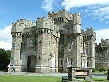 |
Cumbria | 1931 | 1932 | ||
| Wrotham Heath | Kent | 1931 | 1935 | Sandy Wood Farm | ||
| Wymeswold | Leicestershire | 1939 | 1946 | |||
| Yalding | Kent | 1932 | 1937 | Buston Manor | ||
| Yarmouth | Isle of Wight | 1972 | 1983 | |||
| York | 1934 | 1944 | ||||
| York | North Yorkshire | 1945 | 1945 | |||
| Youlgreave | Derbyshire | 1935 | 1935 | |||
| Yoxhall | Staffordshire | 1950 | 1953 | |||
| Ystradfellte | Powys | 1948 | 2005 | |||
| Ystumtuen | Ceredigion | 1961 | 1999 |
Footnotes
- ↑ The regions listed are Wales and the nine Government Office Regions of England
- ↑ The counties listed are the current ceremonial counties of England and the current unitary authorities of Wales
References
- ↑ YHA Alstonefield
- ↑ YHA Castleton Losehill Hall
- ↑ YHA Edale
- ↑ YHA Eyam
- ↑ YHA Hathersage
- ↑ YHA Hartington Hall
- ↑ YHA Ravenstor
- ↑ YHA Manchester
- ↑ YHA Mankinholes
- 1 2 "Hareshaw Hostel". Long Distance Walkers Association. Retrieved 22 November 2016.
- 1 2 3 John Martin. "Y900003 / Youth Hostels Association (England and Wales) / Historical listing of all youth hostels and associated accommodation" (PDF). Retrieved 22 November 2016.
- ↑ "New youth hostel plan for Colchester". Daily Gazette. 3 June 1999. Retrieved 2 August 2011.
Source material
- Neal, Tim; Neal, Simon (1993). Youth Hostels of England and Wales 1931-1993. St Albans: YHA. ISBN 0-9522254-0-9.
- The individual YHA Handbooks issued annually between 1931 and 2002 and biennially since 2003.
| Nations and regions |
| ||||||||||||||
|---|---|---|---|---|---|---|---|---|---|---|---|---|---|---|---|
| Companies | |||||||||||||||
| Organisations | |||||||||||||||
| Industry bodies | |||||||||||||||
| Tourist Destinations |
| ||||||||||||||
| |||||||||||||||