List of World Heritage Sites in Belarus
Location of UNESCO World Heritage Sites within Belarus
This is a list of World Heritage Sites in Belarus with properties of cultural and natural heritage in Belarus. Currently, four properties in Belarus are inscribed on the World Heritage List.[1] Three properties are cultural and one is natural.[1] The tentative list of Belarus contains eleven properties.[1]
Properties on the World Heritage List
* Trans-border site
| # |
Site |
Image |
Location |
Type (criteria) |
Area
ha |
Year |
Ref. |
| 1 |
Belavezhskaya Pushcha National Park (Białowieża Forest) |
|
Brest Province and Grodno Province
(shared with  Poland) Poland)
52°30′N 23°35′E / 52.500°N 23.583°E / 52.500; 23.583 (Belovezhskaya Pushcha / Białowieża Forest)) |
Natural (vii) |
92,669 |
1979, 1992 |
33bis |
| 2 |
Mir Castle Complex |
|
Mir, Grodno Province
53°27′4″N 26°28′22″E / 53.45111°N 26.47278°E / 53.45111; 26.47278 (Mir Castle Complex) |
Cultural (ii, iv) |
— |
2000 |
625 |
| 3 |
Struve Geodetic Arc (five station points) |
|
Brest Province and Grodno Province
(shared with  Estonia, Estonia,  Finland, Finland,  Latvia, Latvia,  Lithuania, Lithuania,  Moldova, Moldova,  Norway, Norway,  Russia, Russia, 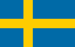 Sweden and Sweden and  Ukraine) Ukraine)
52°09′38″N 25°34′17″E / 52.160556°N 25.571389°E / 52.160556; 25.571389 (Struve Geodetic Arc (Leskovichi station point in Belarus))
52°12′55″N 25°33′12″E / 52.215278°N 25.553333°E / 52.215278; 25.553333 (Struve Geodetic Arc (Chekutsk station point in Belarus))
52°17′21″N 25°38′58″E / 52.289167°N 25.649444°E / 52.289167; 25.649444 (Struve Geodetic Arc (Ossovnitsa station point in Belarus))
53°33′37″N 24°52′11″E / 53.560278°N 24.869722°E / 53.560278; 24.869722 (Struve Geodetic Arc (Lopaty station point in Belarus))
54°17′29″N 26°02′43″E / 54.291389°N 26.045278°E / 54.291389; 26.045278 (Struve Geodetic Arc (Tupishki station point in Belarus)) |
Cultural (ii, iii, vi) |
— |
2005 |
1187 |
| 4 |
Architectural, Residential and Cultural Complex of the Radziwill Family at Nesvizh |
|
Nesvizh, Minsk Province
53°13′22″N 26°41′29″E / 53.22278°N 26.69139°E / 53.22278; 26.69139 (Architectural, Residential and Cultural Complex of the Radziwill Family at Nesvizh) |
Cultural (ii, iv, vi) |
— |
2005 |
1196 |
Properties on the tentative list

Francysk Scaryna avenue in Minsk Wooden church in Zdzitava (Polesye) Location of sites on the tentative list within Belarus
* Trans-border site
| # |
Site |
Image |
Location |
Type (criteria) |
Area
ha |
Year |
Ref. |
| 1 |
Augustow Canal |
|
Grodno Province
(shared with Poland)
53°51′46.3″N 23°37′24.95″E / 53.862861°N 23.6235972°E / 53.862861; 23.6235972 (Augustów Canal. Dąbrówka Lock) |
Cultural (i, ii) |
— |
2004 |
1892 |
| 2 |
Saviour Transfiguration Church and St. Sophia Cathedral in the town of Polatsk |
|
Polotsk, Vitebsk Province
55°30′14.57″N 28°46′49.90″E / 55.5040472°N 28.7805278°E / 55.5040472; 28.7805278 (Saviour Transfiguration Church in Polatsk)
55°29′10.17″N 28°45′30.29″E / 55.4861583°N 28.7584139°E / 55.4861583; 28.7584139 (St. Sophia Cathedral in Polatsk) |
Cultural (i, ii) |
— |
2004 |
1893 |
| 3 |
Kamyanets Tower |
|
Kamyanyets, Brest Province
52°24′17.09″N 23°49′10.31″E / 52.4047472°N 23.8195306°E / 52.4047472; 23.8195306 (Kamyanets Tower) |
Cultural (i, ii, iii) |
— |
2004 |
1894 |
| 4 |
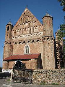
SS. Boris and Gleb (Kalozha) Church in the city of Hrodna |
 |
Hrodna
53°40′42.01″N 23°49′6.73″E / 53.6783361°N 23.8185361°E / 53.6783361; 23.8185361 (SS. Boris and Gleb (Kalozha) Church in Hrodna) |
Cultural (i, ii) |
— |
2004 |
1895 |
| 5 |
St. Nicholas Monastery Complex in the city of Mahilioŭ |
|
Mogilev
53°53′37.83″N 30°20′45.04″E / 53.8938417°N 30.3458444°E / 53.8938417; 30.3458444 (St. Nicholas monastery in Mahilyou) |
Cultural (i) |
— |
2004 |
1896 |
| 6 |
Brest Fortress |
|
Brest
52°4′59.60″N 23°39′33.99″E / 52.0832222°N 23.6594417°E / 52.0832222; 23.6594417 (Brest Fortress) |
Cultural (i, ii, iii) |
— |
2004 |
1897 |
| 7 |
Palace and Park Ensemble in the city of Homel |
 |
Gomel
52°25′19.45″N 31°0′59.75″E / 52.4220694°N 31.0165972°E / 52.4220694; 31.0165972 (Palace and park in Homel) |
Cultural (i, ii) |
— |
2004 |
1898 |
| 8 |
Edifices for Worship of Fortress Type in Belarus, Poland and Lithuania (the churches in Synkavichy, Muravanka, and Kamai) |
|
Brest Province and Minsk Province
53°7′23.08″N 25°9′25.62″E / 53.1230778°N 25.1571167°E / 53.1230778; 25.1571167 (Church of St. Michael, Synkavichy)
53°41′51.76″N 24°59′59.73″E / 53.6977111°N 24.9999250°E / 53.6977111; 24.9999250 (Church of the Birth of the Virgin, Muravanka)
55°3′37.17″N 26°36′19.33″E / 55.0603250°N 26.6053694°E / 55.0603250; 26.6053694 (Church of St. John the Baptist, Kamai) |
Cultural (i) |
— |
2004 |
1899 |
| 9 |
Architectural ensemble of Francysk Scaryna avenue in Minsk (1940s–1950s) |
 |
Minsk
53°53′47″N 27°33′04″E / 53.8965°N 27.551°E / 53.8965; 27.551 (Niezaliezhnastsi avenue in Minsk) |
Cultural (i) |
— |
2004 |
1900 |
| 10 |
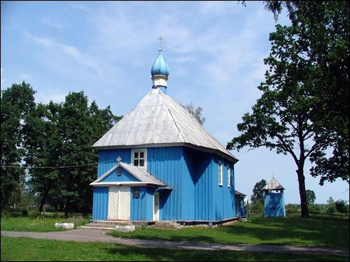
Worship wooden architecture (17th–18th centuries) in Polesye |
|
Brest Province and Gomel Province
52°11′47.71″N 24°3′32.04″E / 52.1965861°N 24.0589000°E / 52.1965861; 24.0589000 (Church of St. Nicetas in Zdzitava, Brest Province) |
Cultural (i, ii, iii) |
— |
2004 |
1901 |
| 11 |
National Park "Belovezhskaya Pushcha" (Modification to the boundaries of the Belarusian part of the site, addition new criteria) |
 |
Brest Province and Grodno Province
52°29′26″N 23°35′26″E / 52.49056°N 23.59056°E / 52.49056; 23.59056 (National Park "Belovezhskaya Pushcha") –
52°56′19″N 24°22′19″E / 52.93861°N 24.37194°E / 52.93861; 24.37194 (National Park "Belovezhskaya Pushcha") |
Natural (ix, x) |
75,958
(Belarusian part) |
2011 |
5592 |
See also
References
|
|---|
|
| History | | |
|---|
|
| Geography | |
|---|
|
| Politics | |
|---|
|
| Economy | |
|---|
|
| Society | |
|---|
|
|

.jpg)


.svg.png)