Laws, California
| Laws | |
|---|---|
| Unincorporated community | |
|
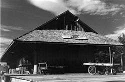
Laws station in 1998. | |
 Laws Location in California | |
| Coordinates: 37°24′03″N 118°20′44″W / 37.40083°N 118.34556°WCoordinates: 37°24′03″N 118°20′44″W / 37.40083°N 118.34556°W | |
| Country | United States |
| State | California |
| County | Inyo County |
| Elevation[1] | 4,117 ft (1,255 m) |
| Time zone | Pacific Time Zone (UTC-8) |
| • Summer (DST) | PDT (UTC-7) |
| GNIS feature ID | 1659742 |
| Official name | Laws Station[2] |
| Reference no. | 953 |
Laws (formerly, Station and Bishop Depot)[3] is an unincorporated community in Inyo County, California.[1] Laws is located 4 miles (6.4 km) northeast of Bishop on U.S. Route 6, towards the Nevada state line.[3] Laws has been noted for its unusual place name.[4]
Geography
The U.S. Geological Survey shows official coordinates for the town as 37°24′03″N 118°20′44″W / 37.40083°N 118.34556°W. The town is in ZIP code 93514 and area code 760. . The official elevation is 4,117 feet (1,255 m) AMSL.[1] The town is bordered by the White Mountains to the east and the Sierra Nevada Mountains, the "Eastern Sierras," to the west. It is located near the Owens River in upper Owens Valley.
History
The settlement of Station was formed in 1883 as a depot on the Carson and Colorado Railroad.[3] The name was changed to Laws in honor of R.J. Laws, a railroad official.[3] A post office operated at Laws from 1887 to 1963.[3] The town of Laws was a railroad station along a 3 ft (914 mm) narrow gauge railway portion of the Southern Pacific Railroad.
Today the town of Laws exists as a museum of Owens Valley and Eastern Sierra Nevada history. It is registered as California Historical Landmark #953.[2]
Laws Railroad Museum and Historic Site
In 2015, the travel website Atlas Obscura designated this museum as one of 160 "international gems."[5]
Railroads displays

The Laws Railroad Museum and Historic Site includes static displays of a train consisting of an oil-fired steam engine Steam locomotive, Southern Pacific #9 and several freight cars from the Southern Pacific Railroad's 3 ft (914 mm) narrow gauge lines. There are also operating locomotives (none of which are steam-powered) that run on the narrow gauge track on the museum's grounds. The museum's display explains that the railroad was relied on by many Eastern Sierra communities before modern roads were built during the 1950s and 1960s.
A station agent's home is located south of the railroad station. Docents portray the station agent on most days, helping visitors understand the period culture.
The Museum includes several historic buildings moved to the museum site from downtown Bishop. There is a church and school house. There is a wooden Western Electric 11-type telephone booth. A vehicle on display was a 1949 ambulance, which was later painted black, stripped of emergency lighting, and used as a hearse. Medical implements from a historic local doctor's office are on display.
Owens Valley history displays
Owens Valley history, including construction and impact of the Los Angeles Aqueduct project, or "Owens Valley Aqueduct," is described in Museum displays. Today, land on all sides of the museum is property of the Los Angeles Department of Water and Power, of the City of Los Angeles. Photographs and docents show and explain that the Valley included large tracts of agricultural land; from the Paiute Native American era, through pioneer days, to the Aqueduct 'water wars era' that began diversions of water in the early 20th century to Los Angeles. A tour docent, sharing a vintage black-and-white photograph, explained "This is a picture of my mom's apple orchard."
Mining displays
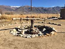
The museum also houses an extensive collection of old and reconstructed mining equipment. Recently, museum volunteers recreated a primitive human- or animal-powered ore-crusher called and arrastra:[5]
A new arrastra was built out of native materials, in this case an elm tree and hardware such as chains found in the museum’s bone yard. An arrastra is a basic mine milling machine used to pulverize rock. A sweep arm – the elm log – is rotated and drags heavy stones over pieces of ore-rich rock to be pulverized. After many rotations, the rock breaks apart and the ore is exposed. It’s heavy labor that was done by a beast of burden before mechanization.
Government
In the California State Legislature, Laws is in the 8th Senate District, represented by Republican Tom Berryhill,[6] and the 26th Assembly District, represented by Republican Devon Mathis.[7]
In the United States House of Representatives, Laws is in California's 8th congressional district, represented by Republican Paul Cook.[8]
See also
Desert railroads
- Tonopah and Tidewater Railroad
- Las Vegas and Tonopah Railroad
- Carson and Colorado Railway
- Death Valley Railroad
- Borate and Daggett Railroad
- Waterloo Mining Railroad
- Calico and Odessa Railroad
- Trona Railway
- List of defunct California railroads
- List of defunct Nevada railroads
Locale
- Bishop, California
- California Water Wars
- Cadillac Desert
- Fish Slough Area of Critical Environmental Concern
- Category: Geography of Inyo County, California
- Inyo National Forest
- Manzanar
- Owens River
References
- 1 2 3 "Laws". Geographic Names Information System. United States Geological Survey.
- 1 2 "Laws Station". Office of Historic Preservation, California State Parks. Retrieved 2012-10-07.
- 1 2 3 4 5 Durham, David L. (1998). California's Geographic Names: A Gazetteer of Historic and Modern Names of the State. Clovis, Calif.: Word Dancer Press. p. 1177. ISBN 1-884995-14-4.
- ↑ Thompson, George E. (1 July 2009). You Live Where?: Interesting and Unusual Facts about where We Live. iUniverse. p. 11. ISBN 978-1-4401-3421-0.
- 1 2 "Website selects Laws as 'hidden gem'" (PDF). Inyo Register. May 28, 2015. Retrieved January 23, 2016.
- ↑ "Senators". State of California. Retrieved April 11, 2013.
- ↑ "Members Assembly". State of California. Retrieved April 11, 2013.
- ↑ "California's 8th Congressional District - Representatives & District Map". Civic Impulse, LLC. Retrieved April 11, 2013.
Sources
- Map: "Laws, California 7.5-minute Quadrangle," U.S. Geological Survey, 1994.
- Map: "Guide to Eastern Sierra, #2463" Automobile Club of Southern California, 1996.
- Map: "Inyo National Forest," U.S. Dept. of Agriculture, U.S. Forest Service, Geometronics Service Center, 1989.
- U.S. Geological Survey, National Geographic Names Database.
