Lauta
This article is about the town in the district of Bautzen, Saxony. For the village in the town of Marienberg, Saxony, see Lauta (Marienberg).
| Lauta | ||
|---|---|---|
| ||
 Lauta | ||
Location of Lauta within Bautzen district 
 | ||
| Coordinates: 51°26′53″N 14°5′59″E / 51.44806°N 14.09972°ECoordinates: 51°26′53″N 14°5′59″E / 51.44806°N 14.09972°E | ||
| Country | Germany | |
| State | Saxony | |
| District | Bautzen | |
| Government | ||
| • Mayor | Hellfried Ruhland | |
| Area | ||
| • Total | 41.87 km2 (16.17 sq mi) | |
| Population (2015-12-31)[1] | ||
| • Total | 8,590 | |
| • Density | 210/km2 (530/sq mi) | |
| Time zone | CET/CEST (UTC+1/+2) | |
| Postal codes | 02991 | |
| Dialling codes | 035722 | |
| Vehicle registration | BZ | |
| Website | www.lauta.de | |

Lauta (Sorbian: Łuty) is a town in the district of Bautzen, in the Free State of Saxony, Germany. It is situated 10 km west of Hoyerswerda, and 10 km southeast of Senftenberg.
History
Within the Prussian Province of Brandenburg, Lauta was part of Landkreis Calau. Within the East German Bezirk Cottbus, it was part of Kreis Hoyerswerda. With German reunification in 1990, it became part of Saxony.
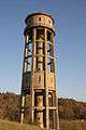 Watertower
 Catholic church
 Housing complex
 Monument in Laubusch, district of Lauta
Personality
Personalities who worked in Lauta
- Albert Zimmermann, resistance fighter, executed on 27 November 1944
Personalities who lived temporarily in Lauta
- Peter Mädler, (1943-1963), death at the Berlin Wall (1963), 1958-1961 electrician apprentice in the power plant Lauta.
- Joachim Hansen, (1930-2007), actor
References
This article is issued from Wikipedia - version of the 10/19/2016. The text is available under the Creative Commons Attribution/Share Alike but additional terms may apply for the media files.