Senftenberg
| Senftenberg | ||
|---|---|---|
|
Market Square | ||
| ||
 Senftenberg | ||
Location of Senftenberg within Oberspreewald-Lausitz district  | ||
| Coordinates: 51°31′N 14°01′E / 51.517°N 14.017°ECoordinates: 51°31′N 14°01′E / 51.517°N 14.017°E | ||
| Country | Germany | |
| State | Brandenburg | |
| District | Oberspreewald-Lausitz | |
| Government | ||
| • Mayor | Andreas Fredrich (SPD) | |
| Area | ||
| • Total | 127.56 km2 (49.25 sq mi) | |
| Population (2015-12-31)[1] | ||
| • Total | 24,625 | |
| • Density | 190/km2 (500/sq mi) | |
| Time zone | CET/CEST (UTC+1/+2) | |
| Postal codes | 01945 (Peickwitz), 01968 (Brieske, Großkoschen, Niemtsch, Sedlitz, Senftenberg), 01996 (Hosena) | |
| Dialling codes | 03573, 035756 (Hosena, Peickwitz) | |
| Vehicle registration | OSL, CA, SFB | |
| Website | www.senftenberg.de | |


Senftenberg (Sorbian: Zły Komorow) is a town in southern Brandenburg, Germany, capital of the Oberspreewald-Lausitz district.
Geography
Senftenberg is located in the southwest of the historic Lower Lusatia region at the border with Saxony. Its town centre is situated north of the river Black Elster and the artificial Senftenberger Lake, part of the Lusatian Lake District chain, approximately 20 kilometres (12 mi) northwest of Hoyerswerda, and 35 kilometres (22 mi) southwest of Cottbus.
Senftenberg station is north of the centre and a major railway freight yard is located to its north-east, with a locomotive depot.
History
![]() March of Lusatia 1279-1368
March of Lusatia 1279-1368
![]() Kingdom of Bohemia 1368-1448
Kingdom of Bohemia 1368-1448
![]() Electorate of Saxony 1448-1806
Electorate of Saxony 1448-1806
![]() Kingdom of Saxony 1806-1815
Kingdom of Saxony 1806-1815
![]() Kingdom of Prussia 1815-1871
Kingdom of Prussia 1815-1871
![]() German Empire 1871-1918
German Empire 1871-1918
![]() Weimar Republic 1918-1933
Weimar Republic 1918-1933
![]() Nazi Germany 1933-1945
Nazi Germany 1933-1945
![]() Allied-occupied Germany 1945-1949
Allied-occupied Germany 1945-1949
![]() East Germany 1949–1990
East Germany 1949–1990
![]() Germany 1990–present
Germany 1990–present
Senftenberg was first mentioned in a 1279 deed issued by Henry III the Illustrious of Wettin, then margrave of Lusatia. With Lower Lusatia, the settlement was acquired by the Kingdom of Bohemia under Charles IV of Luxembourg in 1368. Elector Frederick II of Saxony acquired Senftenberg in 1448, whereafter the area as a border stronghold of the House of Wettin was separated from Bohemian Lusatia, until in 1635 all Lusatian territories fell to Saxony by the Peace of Prague. According to the 1815 Congress of Vienna, Lower Lusatia was annexed by Prussia and incorporated into the Province of Brandenburg.
Names
- Czech: Zlý Komorov
- German: Senftenberg
- Polish: Zły Komorów
- Upper Sorbian: Zły Komorow
- Lower Sorbian: Zły Komorow
International relations
Senftenberg is twinned with:
-
 Püttlingen, Germany
 -
 Nowa Sól, Poland
 -
 Senftenberg, Austria
 -
 Saint-Michel-sur-Orge, France
 -
 Veszprém, Hungary
 -
 Žamberk, Czech Republic
 -
 Fresagrandinaria, Italy
 -
 Ber, Mali
Tourism
Lake "Senftenberger See"
The Senftenberger See (Senftenberger Lake) is a popular destination for both day trips and holiday. In 1973, the former open cast mine, was officially opened to the public. Today, the lake is known for its excellent water quality. It is part of the socalled Lusatian Lakeland, a group of 23 artificial lakes. On sunny afternoons, many locals go for a bike trip around the lake on an 18 km paved cycle path, which is connected to a number of regional and national cycle paths. Around the lake, there are various housing options. (klick here)
- Beach hotel
The lakeside beach hotel on the northern shore offers a marvelous view onto the island in the middle of the lake. From here, it is just a walking distance to the very town center.
- Holiday resort
On the southern shore located in a forest right above a long sandy beach, the holiday resort "Family park Senftenberger See" is focused on families. It offers accommodation for about 2600 people. This resort also includes a well maintained camp site. It is localed in the area of Großkoschen.
- Camp site
An other big camp site is situated on the western shore in the area of Niemtsch. Both areas belong to the town of Senftenberg.
- Passenger boat
In summer, the passenger boat "Santa Barbara" offers regular service between the town center, Großkoschen and Niemtsch.
- Sailing
The aquatic sports center located close to the holiday resort in the area of Großkoschen offers - next to a bunch of activities - sailing boats for rent.
A beach close to the Beach hotel is well known for wind surfing. Equipment for rent is offered right on the beach. In 2010, the construction of the new marina was started. It will be located a stone's throw from the town center.
Nearby Attractions and Destinations
- EuroSpeedway Lausitz - 8 km
- Cottbus - 40 km
- Spreewald - wetland forest accessible through a network of about 200 small channels, designated a biosphere reserve by UNESCO - 50 km
- excursion to an operating coal mine - Welzow - appr. 20 km
- quad bike tours through former mining landscapes - appr. 20 km
- Dresden - 66 km
- Berlin - appr. 140 km
Demography
After the second half of the 19th century the inhabitants increased because of workers coming to Senftenberg to work in the coal mines. After the German Reunion, many inhabitants moved to the western part of Germany.
| Developing of the number of inhabitants in Senftenberg from 1300 to 2007[2][3] | ||||||||||||||||
|---|---|---|---|---|---|---|---|---|---|---|---|---|---|---|---|---|
| Year | Inhabitants | Year | Inhabitants | Year | Inhabitants | Year | Inhabitants | Year | Inhabitants | Year | Inhabitants | |||||
| 1300 | 400 | 1858 | 1.517 | 1939 | 17.566 | 1989 | 31.580 | 1996 | 26.647 | 2003 | 29.474 | |||||
| 1474 | 600 | 1867 | 1.638 | 1946 | 17.783 | 1990 | 29.622 | 1997 | 27.109 | 2004 | 29.136 | |||||
| 1555 | 900 | 1875 | 2.847 | 1950 | 18.260 | 1991 | 28.840 | 1998 | 26.424 | 2005 | 28.774 | |||||
| 1575 | 918 | 1890 | 5.134 | 1964 | 24.053 | 1992 | 28.470 | 1999 | 25.576 | 2006 | 28.071 | |||||
| 1680 | 1.150 | 1910 | 13.742 | 1971 | 24.367 | 1993 | 28.123 | 2000 | 24.740 | 2007 | 27.515 | |||||
| 1806 | 979 | 1925 | 17.472 | 1981 | 32.005 | 1994 | 27.637 | 2001 | 30.539 | 2012 | 25.061 | |||||
| 1818 | 819 | 1933 | 17.803 | 1985 | 32.278 | 1995 | 27.336 | 2002 | 29.957 | 2013 | 24.987 | |||||
 Development of Population since 1875 within the Current Boundaries (Blue Line: Population; Dotted Line: Comparison to Population Development of Brandenburg state; Grey Background: Time of Nazi rule; Red Background: Time of Communist rule)
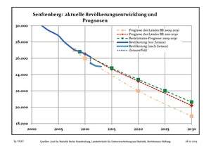 Recent Population Development (Blue Line) and Forecasts
Photogallery
 Senftenberg
(Old Town) Estate housing
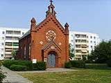 Lutheran church
in "Jüttendorf"
See also
References
- ↑ "Bevölkerung im Land Brandenburg nach amtsfreien Gemeinden, Ämtern und Gemeinden 31. Dezember 2015 (Fortgeschriebene amtliche Einwohnerzahlen auf Grundlage des Zensus 2011)". Amt für Statistik Berlin-Brandenburg (in German). 2016.
- ↑ Werner Forkert: Senftenberger Rückblicke Interessantes aus der Senftenberger Geschichte. Herausgeber Buchhandlung „Glück Auf“, 2006. (for data before the year 1875)
- ↑ Statistik Brandenburg: Data since 1875 (download as pdf, 330 kB)
External links
![]() Media related to Senftenberg at Wikimedia Commons
Media related to Senftenberg at Wikimedia Commons
Towns and municipalities in Oberspreewald-Lausitz | ||
|---|---|---|