Lakin Township, Kearny County, Kansas
| Lakin Township | |
|---|---|
| Township | |
 Location in Kearny County | |
| Coordinates: 38°00′09″N 101°16′04″W / 38.00250°N 101.26778°WCoordinates: 38°00′09″N 101°16′04″W / 38.00250°N 101.26778°W | |
| Country | United States |
| State | Kansas |
| County | Kearny |
| Area | |
| • Total | 63.26 sq mi (163.85 km2) |
| • Land | 63.24 sq mi (163.79 km2) |
| • Water | 0.02 sq mi (0.06 km2) 0.04% |
| Elevation | 3,186 ft (971 m) |
| Population (2000) | |
| • Total | 2,587 |
| • Density | 40.9/sq mi (15.8/km2) |
| GNIS feature ID | 0485281 |
Lakin Township is a township in Kearny County, Kansas, USA. As of the 2000 census, its population was 2,587.[1]
Geography
Lakin Township covers an area of 63.26 square miles (163.85 square kilometers); of this, 0.02 square miles (0.06 square kilometers) or 0.04 percent is water. The stream of Sand Creek runs through this township.
Cities and towns
- Lakin (the county seat)
Adjacent townships
- East Hibbard Township (north)
- Deerfield Township (east)
- Southside Township (southeast)
- Kendall Township (southwest)
- Hartland Township (west)
- West Hibbard Township (northwest)
Cemeteries
The township contains one cemetery, Lakin.
Major highways
Airports and landing strips
- Lakin Landing Field
References
External links
Municipalities and communities of Kearny County, Kansas, United States | ||
|---|---|---|
| Cities | 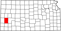 | |
| Townships | ||
This article is issued from Wikipedia - version of the 6/29/2014. The text is available under the Creative Commons Attribution/Share Alike but additional terms may apply for the media files.