Lake of the Ozarks
| Lake of the Ozarks | |
|---|---|
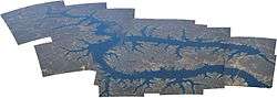 Aerial panorama of Lake of the Ozarks | |
| Location | Benton, Camden, Miller, and Morgan Counties in Missouri |
| Coordinates | 38°12′09″N 92°37′35″W / 38.20250°N 92.62639°WCoordinates: 38°12′09″N 92°37′35″W / 38.20250°N 92.62639°W |
| Type | Reservoir |
| Primary inflows | Grandglaize Creek, Gravois Creek, Niangua River, Osage River |
| Primary outflows | Osage River |
| Catchment area | 14,000 sq mi (36,300 km2) |
| Basin countries | United States |
| Managing agency | Ameren Missouri |
| Built | August 6, 1929 |
| First flooded | February 2, 1931 |
| Max. length | 93 miles (150 km)[1] |
| Surface area | 54,000 acres (220 km2)[2] |
| Max. depth | 130 ft (40 m)[3] |
| Water volume | 1,927,000 acre·ft (2.377×10⁹ m3)[1] |
| Residence time | 2-4 months |
| Shore length1 | 1,150 miles (1,850 km) |
| Surface elevation | 660 ft (201 m) |
| Settlements | Camdenton, Lake Ozark, Laurie, Osage Beach, Sunrise Beach, Village of Four Seasons |
| References | [2][3][4] |
| 1 Shore length is not a well-defined measure. | |
The Lake of the Ozarks is a large reservoir created by impounding the Osage River in the northern part of the Ozarks in central Missouri. Extents of three smaller tributaries to the Osage, the Niangua River, Grandglaize Creek, and Gravois Creek, are included in the impoundment. The lake has a surface area of 54,000 acres (220 km2), 1,150 miles (1,850 km) of shoreline, and the main channel of the Osage Arm stretches 92 miles (148 km) from end to end. The total drainage area is over 14,000 square miles (36,000 km2). The lake's serpentine shape has earned it the nickname "The Magic Dragon," which has in turn inspired the names of local institutions such as The Magic Dragon Street Meet.[5]
History
A hydro-electric power plant on the Osage River was first pursued by Kansas City developer Ralph Street in 1912. Street put together the initial funding and began building roads, railroads and infrastructure necessary to begin construction of the dam, with a plan to impound a much smaller lake. In the mid-1920s, Street’s funding dried up and he abandoned the effort.[6]
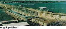
The lake was created by the construction of the 2,543-foot (775 m) long Bagnell Dam by Union Electric Company of St. Louis, Missouri. The principal engineering firm was Stone and Webster. Construction began August 8, 1929, was completed in April 1931, and reached spillway elevation on May 20, 1931. During construction the lake was referred to as "Osage Reservoir" or "Lake Osage". The Missouri General Assembly officially named it "Lake Benton" after the former Senator Thomas Hart Benton. None of the names took as it was popularly referred to by its location in the Ozarks. The electric generating station, however, is still referred to by the utility company as the "Osage Hydroelectric Plant".[7]
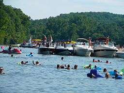
At the time of construction it was one of the largest man-made lakes in the world and the largest in the United States. Though built to provide hydroelectric power for customers of Union Electric, the lake quickly became a significant tourist destination for the Midwest. Unlike many flood-control lakes in the region constructed by the U.S. Army Corps of Engineers, most of the shoreline on the Lake of the Ozarks is privately owned, and the relatively stable surface elevation has created ideal conditions for private development within a few feet of the shoreline. There are over 70,000 homes existing along the lake, many of which are vacation homes. Spectacular scenery characteristic of the Ozarks has also helped to transform the lake into a major resort area. More than 5 million people visit the lake annually.
In 2011, the Federal Energy Regulatory Commission (FERC), in the process of renewing the lease for the power plant operated by Ameren Missouri, determined that numerous homes and structures were encroaching on utility land in violation of federal regulations. This issue "has triggered panic in the area's lakefront communities and led to a growing battle among regulators, a utility company, land attorneys and the state's congressional delegation." [8]
Geography
The Lake of the Ozarks is located at 38°12′09″N 92°37′35″W / 38.20250°N 92.62639°W (38.2025326, -92.6262966) at an elevation of 568 feet (173 m).[4] It lies in central Missouri on the Salem Plateau of the Ozarks.[9] The lake extends across four Missouri counties, from Benton County in the west through Camden County and Morgan County to Miller County in the east.[10]
The reservoir is impounded at its northeastern end by Bagnell Dam, and the Osage River is both its primary inflow and outflow.[10] Long and winding in shape, the lake consists of the main, 93-mile-long (150 km) Osage River channel as well as several arms, each fed by a different tributary.[1][10] The southwestern arm is fed by the Niangua and Little Niangua Rivers,[11] the southeastern arm by Grandglaize Creek,[12] and the northern arm by several streams including Gravois Creek, Indian Creek, and Little Gravois Creek.[13] Many smaller tributaries also drain into the lake, creating numerous small coves and indentations in its shore.[11][12][13] As a result, the lake has approximately 1,150 miles (1,850 km) of shoreline.[2]
U.S. Route 54 runs east-west across the reservoir's southwestern arm and then generally northeast-southwest along its eastern shoreline, crossing the southeastern arm at Osage Beach. Missouri Route 5 runs generally north-south along the lake's western shoreline, crossing the main channel at Hurricane Deck. Missouri Route 7 runs generally northwest-southeast to the lake's southwest, crossing the southwestern arm. Missouri Route 134 runs southeast from U.S. 54 north of Osage Beach to its southern terminus in Lake of the Ozarks State Park. In addition, a network of lettered, supplemental state routes provides access to various points along the lake shore.[10]
Numerous settlements are located near or on the Lake of the Ozarks. The largest is Osage Beach which sits where the lake's southeastern arm joins the main channel. The second largest is the city of Camdenton, located on U.S. 54 a few miles east of the southwestern arm. Lake Ozark lies immediately north of Osage Beach and just south of Bagnell Dam. Other, smaller communities along or near the lake include (from east to west): Kaiser, Lakeside, Linn Creek, Village of Four Seasons, Rocky Mount, Sunrise Beach, Hurricane Deck, Gravois Mills, Laurie, and Lakeview Heights.[10]
Hydrography
The Lake of the Ozarks has a storage capacity of approximately 1,927,000 acre feet (2.377×10⁹ m3).[1] When filled to that volume, it has a surface elevation of 660 feet (200 m) and occupies a surface area of approximately 54,000 acres (220 km2).[2][14] The lake rarely varies in surface elevation by more than 5 feet (1.5 m).[14] As it was constructed for power generation, not flood control, the lake has only limited flood control capacity.[1]
Due to its large volume and surface area, various sources identify the Lake of the Ozarks as either the largest reservoir in Missouri or the second-largest after Truman Reservoir.[15][16][17]
Infrastructure
Bridges
Here is a list of historic bridges that were on the lake.
- Grand Glaize Bridge — Replaced by two girder bridges.
- Hurricane Deck Bridge — Replaced in 2014
- Niangua Bridge — Replaced by a girder bridge.
- Niangua Arm US 54 Bridge — Replaced by a girder bridge.
Management
Bagnell Dam is operated and maintained by Ameren Missouri, the successor of Union Electric, under the authority of a permit issued by the Federal Energy Regulatory Commission. Ameren Missouri is also responsible for managing both the shoreline and water levels of the lake. All land surrounding the lake that is within the project boundary defined by the FERC is under the company's jurisdiction. Any improvements to the shoreline including docks, seawalls, and other structures require permission from Ameren Missouri prior to construction.[18]
Tourism and recreation
Parks
During the process of land acquisition for the lake during the 1920s, 17,500 acres (71 km2) of land along the Grand Glaize Arm of the lake was set aside for a national park. In 1946, this land was acquired by the State of Missouri for Lake of the Ozarks State Park, the largest State Park in Missouri. Lake of the Ozarks State Park is home to Party Cove, a rowdy gathering spot that a travel writer for The New York Times called the "oldest established permanent floating bacchanal in the country."[19] The Missouri State Water Patrol has estimated that the cove attracts up to 3000 boats during the Fourth of July weekend.[19]
Another state park on the shores of the lake is Ha Ha Tonka State Park on the Niangua Arm of the lake.
Golf courses
The Lodge of Four Seasons (Championship Course). Classic Robert Trent Jones design occupies raised fingers of land that jut into the lake. Signature par-three 13th calls for a long carry over a cove to reach the green. One of the Midwest's prettiest, most challenging courses.[20]
Osage National Golf Club. This Arnold Palmer layout is a big-time test (7,150 yards from tips) nestled between the Lake of the Ozarks and the imposing bluffs of the Osage River. Creeks, lakes, and large, undulating bentgrass greens defend par.[21]
Shawnee Bend Golf Course. Classic Ozark golf on the far Westside of the Lake in Warsaw. Opened in 1985, it is now considered one of the best 9 hole courses in the Midwest. Signature par-three 5th hole is one of the most scenic holes in the state of Missouri.
Media
Radio
| Frequency | Callsign | Nickname | Format | Owner | City of License | Web site |
|---|---|---|---|---|---|---|
| 89.3FM | KIRL | Gospel | Full Smile, Inc. | Osage Beach, MO | [] | |
| 90.3FM | KCRL | Religion | Bott Radio | Sunrise Beach, MO | ||
| 91.7FM | KCVO-FM | Spirit FM | Christian Contemporary | Lake Area Educational Broadcasting Foundation | Camdenton, MO | |
| 92.7FM | KLOZ | Mix 92.7 | Hot AC | Benne Broadcasting Company, LLC | Eldon, MO | |
| 93.5FM | KMYK | 93.5 Rocks the Lake | Classic Rock | Viper Communications, Inc. | Osage Beach, MO | |
| 95.1FM | KTKS | KS95 | Country | Benne Broadcasting Company, LLC | Versailles, MO | |
| 97.1FM | KAYQ | The Lake | Classic Country | Valkyrie Broadcasting, Inc. | Warsaw, MO | |
| 97.5FM/104.9FM/1150AM | KRMS | NewsTalk KRMS | Talk | Viper Communications, Inc | Osage Beach, MO | |
| 100.9FM | KCKP | The Pulse Channel | Christian Rock | Lake Area Educational Broadcasting Foundation | Laurie, MO | |
| 101.9FM | KZWV | 101.9 The Wave | Adult Contemporary | Zimmer Radio of Mid-Missouri, Inc. | Eldon, MO | |
| 102.7FM | KQUL | Classic Hits Cool 102.7 | Classic Hits | Benne Broadcasting Company, LLC | Lake Ozark, MO | |
| 107.9FM | KCLQ | 107.9 The Coyote | Country | Go Productions, LLC | Lebanon, MO |
Television
| Display Channel | Network | Callsign | Owner | City of License | Web site |
|---|---|---|---|---|---|
| 49.1 | FOX | KRBK | Koplar Communications | Osage Beach, Missouri | |
| 49.2 | Me-TV | ||||
| 49.4 | Movies! | ||||
References
- 1 2 3 4 5 "Hydrology". Missouri Department of Conservation. Retrieved 2015-12-02.
- 1 2 3 4 Great Osage River Project from the website of the Lake of the Ozarks Convention & Visitor Bureau
- 1 2 "Midwest Diving Locations". Columbus Sea Nags Scuba Diving Club. Retrieved 2007-07-14.
- 1 2 "Lake of the Ozarks". Geographic Names Information System. United States Geological Survey. Retrieved 2015-12-02.
- ↑ "Magic Dragon Street Meet Lake of the Ozarks : Car Show Lake of the Ozarks MO". Lake Area Chamber of Commerce. Retrieved 2011-07-24.
- ↑ Lake of the Ozarks, Missouri, the premier vacation spot in the Midwest
- ↑ Lake of the Ozarks Name
- ↑ Chris Blank (2011), Mo. residents upset by order to move lake homes, retrieved 2011-11-07
- ↑ "Physiographic Regions of Missouri [Map]" (PDF). Missouri Department of Natural Resources. 2002. Retrieved 2015-12-02.
- 1 2 3 4 5 "Missouri Highway Map" (PDF). Missouri Department of Transportation. 2013. Retrieved 2015-12-02.
- 1 2 "General Highway Map - Camden County" (PDF). Missouri Department of Transportation. June 2011. Retrieved 2015-12-02.
- 1 2 "General Highway Map - Miller County" (PDF). Missouri Department of Transportation. October 2011. Retrieved 2015-12-02.
- 1 2 "General Highway Map - Morgan County" (PDF). Missouri Department of Transportation. December 2011. Retrieved 2015-12-02.
- 1 2 "Lake Ozark Guide Curve - 2015". Ameren Missouri. Retrieved 2015-12-03.
- ↑ Foley, William E.; McCandless, Perry (2001). Missouri Then and Now. Columbia, MO: University of Missouri Press. p. 37.
- ↑ Keefer, Greg (2011-08-31). "10 Great Missouri Bass Lakes". Game & Fish. Retrieved 2015-12-03.
- ↑ "Lakes in Missouri, United States". Lakes Online. Retrieved 2015-12-03.
- ↑ "Shoreline Management". Ameren Missouri. Retrieved 2015-12-18.
- 1 2 Party Cove: Wild in the Ozarks, a July 2005 article from The New York Times
- ↑ McCallen, Brian. "Lake of the Ozarks."Golf Magazine on the Web.15 September 2008 .
- ↑ Golf Magazine
External links
| Wikimedia Commons has media related to Lake of the Ozarks. |
 Lake of the Ozarks travel guide from Wikivoyage
- Lake of the Ozarks, Ameren Missouri
- Lake of the Ozarks, Lake of the Ozarks Convention & Visitor Bureau
- Ha Ha Tonka State Park, Missouri Department of Natural Resources
- Lake of the Ozarks State Park, Missouri Department of Natural Resources